JOHNSTON RIDGE — St. Helens and Spirit lakes sparkle and shimmer to the east, Mount St. Helens’ gaping crater towers to the south, and the sweeping Toutle River valley unfolds to the west.
And this ridgetop, panoramic view — available while sitting amid penstemon, paintbrush and other colorful wildflowers — isn’t even the highlight of the trip on Boundary trail No. 1 to Coldwater Peak north of Mount St. Helens.
What everyone remembers is the hole in the rock.
There’s a huge opening where the trail passes through a natural arch, traversing from the west to the east side of a ridge.
Peter Frenzen, Mount St. Helens National Volcanic Monument scientist, said the arch existed before the 1980 eruption.
The arch is shady on a hot day and serves as a cooling funnel for the predominating westerly breeze.
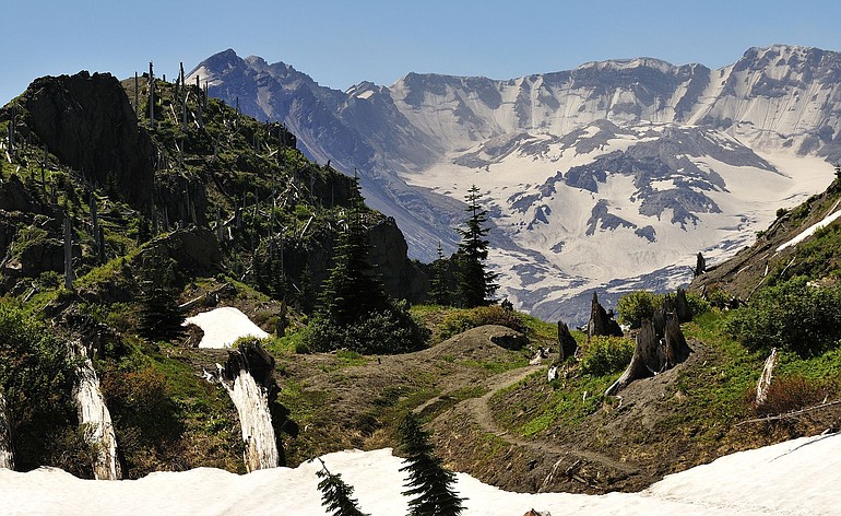
The hike from Johnston Ridge to the top of 5,727-foot Coldwater Peak is the highlight of a visit to the north side of the volcano. It’s seven miles (one way) with 1,500 feet elevation gain, so this is a long jaunt.
But the country in the St. Helens Lake basin is fantastic, and from atop Coldwater Peak the view includes four lakes, four mountains and a grand look of the land’s recovery 30 years after the big blast.
“I’d rate it a 9,’’ said hiker Linda Hungerford of southeast Portland. “I’d give it a 10 if it didn’t start at Johnston Ridge. It’s like starting at a Walmart lot.’’
Mike Newsham of the Sierra Club’s Loowit Group rates it among his five favorite hikes.
“The views were incredible,’’ said Newsham, who lead a group of nine on the route in mid-July. “It would have been in the top 3 except that the start of the hike goes downhill, with the result that the hike ends with about a ¾-mile pull uphill, which is a killer at the end of a long day…..It’s no one’s fault — just the geography of the place. This is well worth the 4 hours of round-trip driving time.’’
For the initial five miles heading east from popular Johnston Ridge Observatory, the Boundary trail seems much like other routes in the Mount St. Helens blast zone — dry and dusty, with flowers, brush and trees slowly reclaiming the terrain.
Then, the trail enters the basin containing sapphire, 79-acre St. Helens Lake.
The basin is mostly green, with additional varieties of wildflowers. Scattered about are the bleached and standing lower portions of the big trees snapped off here on May 18, 1980.
There’s no fishing, and no off-trail travel in St. Helens Lake basin.
Before 1980, St. Helens Lake contained eastern brook, cutthroat and lake trout. The Washington Department of Fish and Wildlife has surveyed the lake at least four times since 1981.
In 2000, 15 lake trout were captured using a gillnet. Those fish averaged almost 17 inches in length.
According to a 2007 report by state fish biologists John Weinheimer and Bob Lucas, brook trout disappeared from the deep lake after the 1980 eruption.
“As brookies are more surface-oriented than lake trout, the blast could have selectively killed brook trout,’’ the report states. “Another possible reason for the survival of lake trout is their spawning adaptability. Although preferring rubble and gravel bottoms, they can be successful in mud and sand.’’
The Forest Service limits backcountry camping north of Mount St. Helens to eight designated spots.
Three camps are along Boundary trail No. 1 northeast of St. Helens Lake, one camp is on Coldwater trail No. 230 and four camps are near lakes north of Mount Margaret. Camping permits are required. The permits are free, but need a Northwest Forest Pass ($5 daily, $30 for 12 months) to be valid.