TROUT LAKE — Check the guidebooks for Mount Adams and there will be scant — if any — mention of Shorthorn trail No. 16 or Lookingglass Lake.
That’s because with stunning Bird Creek and Hellroaring meadows a few miles to the east, and Takhlakh Lake, Killen Creek and High Camp to the north, the southwest portion of the mountain gets little attention.
There’s no arguing the Bird Creek and Killen Creek backcountry deserve marquee billing, but the southwest side of Mount Adams Wilderness is far from a dud.
“We only really backpack two places, here and the Oregon coast,’’ said Ben Thompson of Keizer, Ore., working his way up Shorthorn trail with wife, Sara, on the way to Horseshoe Meadow. “This is my favorite place.’’
One the the benefits of hiking in places less publicized, the Thompsons had Shorthorn trail and Round-the-Mountain trail No. 9 pretty much to themselves on a Friday in August.
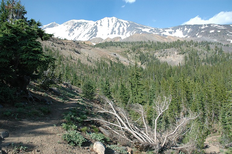
Shorthorn trail No. 16 starts at rustic Morrision Creek campground and climbs 2.9 miles to junction with Round-the-Mountain trail.
For a nice day hike, follow Round-the Mountain No. 9 west for 2.5 miles to a junction with Lookingglass Lake No. 9A, then down No. 9A for a mile to the small lake.
Shorthorn trail was developed by sheepherders in the late 1800s, according to the Gifford Pinchot National Forest website. Herders traveled from as far away as eastern Oregon to graze their animals on the summer ranges of Mount Adams.
This hike starts at the trailhead at Morrison Creek campground.
Shorthorn trail climbs through sparse and scraggly pines up the slope and through rocky washes reaching a sandy flat at 1.89 miles and a nice stream with clear water (some of the creeks have a bit of glacial tint) at 2.19 miles.
While Shorthorn trail No. 16 has been pretty pedestrian to this point, from here on the views improves and the wildflowers increase.
In another half-mile comes a crossing of Crofton Creek in a steep gully.
Darryl Lloyd of the Friends of Mount Adams group said Mount Adams was hammered by the same record-breaking rains in November 2006 that wiped out roads on Mount St. Helens.
The flooding carved a deep chasm in the Salt Creek drainage, with some of the volume overflowing into Crofton Creek.
The storm exposed a layer of buried ice near Avalanche Glacier.
Once on the west side of Crofton Creek, the trail climbs sharply to the junction with Round-the-Mountain trail at a saddle on Crofton Ridge.
Heading west, this is a fine — almost-level — stretch on Round-the-Mountail trail to the junction with Lookingglass Lake trail No 9A. There are several stream crossings of the headwaters of Salt and Cascade creeks that require hopping from rock to rock.
It’s a mile gradually down hill (400 feet elevation loss) to small and shallow Lookingglass Lake. Go slowly, and watch for cairns and ribbon, because Lookingglass Lake trail is a bit undefined in places.
With a couple of small tributaries carrying snowmelt, Lookingglass is cold (not just cool) to the touch.
There are a couple of camp sites near the shore of the lake.
The distance from the trailhead to the lake (one way) is 6.37 miles.