• SIOUXON — Follow state Highway 503 to Chelatchie. At the store, turn right on Healy Road and go 2.2 miles to a four-way intersection. Keep straight on Gifford Pinchot road No. 54 for 6.8 miles to the junction with road No. 57. Go up road No. 57 for 1.2 miles to road No. 5701 and follow No. 5701 for 3.7 miles to the end.
• DOG MOUNTAIN — Follow state Highway 14 east past Home Valley to milepost 53. There is a big parking lot on the north side of the road.
• GOAT LAKE — Take Interstate 5 north to exit 68, then U.S. Highway 12 west 65 miles almost to the community of Packwood. Turn right on Gifford Pinchot road No. 21 for 15.7 miles to tiny Hugo Lake. Turn on to road No. 2150 and follow the signs to Chambers Lake and Berry Patch or Snowgrass trailhead.
Classic never gets old, certainly not classic trails.
It matters not whether the route visits the rock and ice of mountains, a stream deep in a canyon or meadows carpeted by wildflowers.
• SIOUXON -- Follow state Highway 503 to Chelatchie. At the store, turn right on Healy Road and go 2.2 miles to a four-way intersection. Keep straight on Gifford Pinchot road No. 54 for 6.8 miles to the junction with road No. 57. Go up road No. 57 for 1.2 miles to road No. 5701 and follow No. 5701 for 3.7 miles to the end.
• DOG MOUNTAIN -- Follow state Highway 14 east past Home Valley to milepost 53. There is a big parking lot on the north side of the road.
• GOAT LAKE -- Take Interstate 5 north to exit 68, then U.S. Highway 12 west 65 miles almost to the community of Packwood. Turn right on Gifford Pinchot road No. 21 for 15.7 miles to tiny Hugo Lake. Turn on to road No. 2150 and follow the signs to Chambers Lake and Berry Patch or Snowgrass trailhead.
The 1.3-million-acre Gifford Pinchot National Forest is blessed with several classic trails. Straddling the crest of the Cascade Mountains from Mount Rainier south to the Columbia River, the Pinchot forest has six wilderness areas and a chunk of a seventh. There’s an active volcano in Mount St. Helens, a sleeping volcano in Mount Adams and the remnants of a volcano in the Goat Rocks.
There’s majestic old-growth in Trapper Creek Wilderness and grand meadows in Indian Heaven Wilderness.
Here’s a look at three Gifford Pinchot National Forest trails, each of them a classic:
Siouxon Creek No. 130 — The trail follows gorgeous Siouxon (pronounced sue-sawn) Creek for several miles. At 1,300 to 1,500 feet, the trail has a long hiking season.
Depending on the winter’s snow, the trailhead can be accessible in early April and open until early December. The best time to visit Siouxon Creek is at the peak of snowmelt, normally in early June.
Siouxon Creek starts at Timbered Peak in Skamania County and flows 20 miles west to Yale Reservoir on the North Fork of the Lewis River. The clarity of the creek is amazing, due in no small amount to the lack of roads and logging in the upper watershed.
The stream is a relatively close-to-home gem, only a few miles east of Chelatchie Prairie.
The Forest Service, not an agency given to hype, described Siouxon Creek this way in its 1990 land-use plan: “Its subtle beauty below the forest canopy and a wide variety of water features from pools and riffles to spectacular waterfalls make it one of the most scenic rivers in the state of Washington.”
Most hikers on Siouxon Creek trail No. 130 walk the approximately four miles from the trailhead at the end of road No. 5701 to Chinook Falls, a 50-foot plunge on a tributary stream.
Hikers resting near the pool at the bottom of Chinook Falls often need to put on a jacket for a respite from the wind swirl and spray.
Heading east (upstream) from the trailhead, trail No. 130 drops to cross West Creek on a log bridge. At about 1.25 miles (25 minutes), trail No. 130 junctions with Horseshoe Ridge trail No. 140.
Continuing east, trail No. 130 crosses Horseshoe Creek at a 60-foot falls in another 15 minutes. Just beyond the crossing, a side trail leads back to a better view of the falls. At another 30 minutes down the trail, a view of Siouxon Falls is available from the trail. A bench has been built at the viewpoint.
It takes about another hour to the bridge across Siouxon Creek. Just before the bridge, a tributary flowing from the south has to be crossed. During the runoff, that might mean wet feet or scrambling up the tributary and crossing on a downed log.
Cross Siouxon Creek on the bridge and go up trail No. 130A for about a quarter of a mile to Chinook Creek Falls, the highlight of the trip.
Dog Mountain — The Dog Mountain trail is so popular there was a parking lot attendant directing traffic on Memorial Day weekend last year, trying to squeeze as many vehicles as possible in the big parking area along state Highway 14.
The summit of Dog Mountain is certainly no secret. The wildflower display including balsamroot, lupine, paintbrush and others is spectacular in late May and early June. The peak of the bloom varies a bit each year, but the first week in June is a good time to hike this classic.
The trailhead is at milepost 53 along Highway 14 in eastern Skamania County.
Hikers can make a loop out of this trip, which is a steep climb.
Head left from the trailhead, going up Augspurger trail No. 4407. This option makes the route to the summit a little longer, but the grade is a bit milder. The trailhead is at about 150 feet elevation. Augspurger trail climbs the west side of Dog Mountain and junctions at 3.12 miles (2,174 elevation) to a connecting trail to Dog Mountain.
Stay right and at 4.05 miles is a junction with Dog Mountain trail (2,747 elevation). Turn left and make the final push to the summit at 2,900 feet.
Coming down, stay on Dog Mountain trail No. 147, thus descending on the east side of the peak. At the trail junction, select the eastern (newer and easier) route.
A Northwest Forest Pass ($5 a day/$30 for 12 months) is required to park at Dog Mountain.
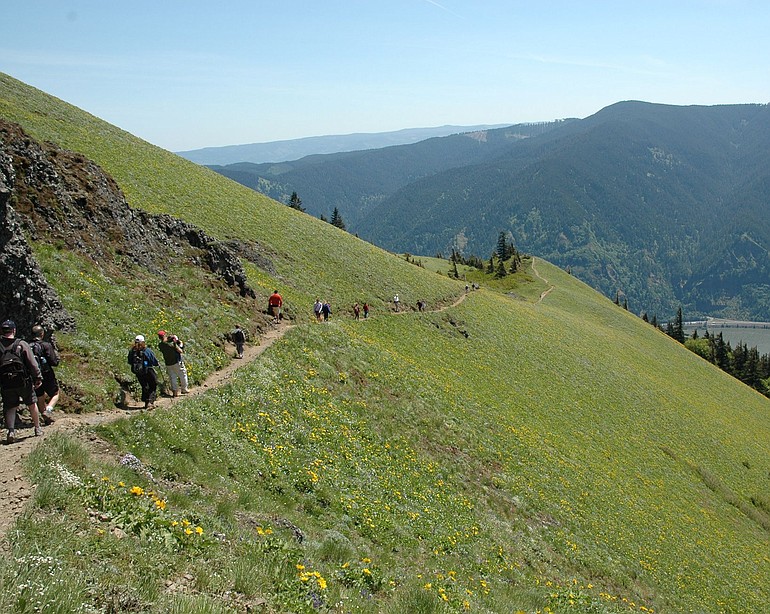
Goat Lake loop — The loop using Snowgrass trail No. 96, Lily Basin trail No. 86 and Goat Ridge trail No. 95 is arguably the best hike the Gifford Pinchot National Forest. It’s a long way from Clark County — and worth every mile of the drive.
The loop starts at Berry Patch trailhead at the end of Gifford Pinchot road No. 2150405, elevation 4,500 feet.
Berry Patch was the site of a Forest Service ranger station from 1910 to the 1930s. Long before that, the site was an important berry-picking site for the Taidnapam (Upper Cowlitz) and Yakama tribes.
At Berry Patch, head up Snowgrass trail No. 96, not Goat Ridge No. 95, which begins at the same location. At 0.73 miles, trail No. 96 junctions with trail No. 96A, which comes in from the Snowgrass trailhead.
At 2.26 miles, Snowgrass trail crosses Goat Creek on a bridge. Although there have been a few ups and down, the elevation gain has been minor to this point.
After Goat Creek, the trail passes briefly through a swampy area, then begins to climb steadily, although not terribly steep.
A small waterfall is passed at 3.9 miles (5,260 feet elevation) and junctions with Bypass trail No. 976 at 4.49 miles (5,547 feet elevation).
Snowgrass trail No. 96 continues another half-mile to the junction with Lily Basin trail No. 86. Another option is to follow Bypass No. 97 for 1.34 miles to the Pacific Crest National Scenic Trail (elevation 5,907 feet).
Turn left at the PCT, and hike a mile north to the junction with Snowgrass trail No. 96, then left on No. 96 for 0.9 mile to the junction with Lily Basin No. 86.
The purpose for the added distance is to enjoy the best of Snowgrass Flat. It’s a detour that’s optional early and late in the season, but should not be passed up during the peak of the wildflowers.
Once on Lily Basin trail No. 86, it is 2.36 miles to Goat Lake (elevation 6,380 feet) through stunning country. Goat Creek flows out of Goat Lake via a waterfall and the upper Goat Creek Basin is worth the trip alone.
It’s a magnificent U-shaped basin, with Goat Lake in a cirque at the top. Views of Mount Adams to the south add to the experience.
Goat Lake comes at 10.1 miles in the loop. Goat Lake remains frozen until mid-August at the earliest.
Goat Lake is great spot for a rest break. Take time to watch the steep slopes above the lake. Mountain goats are commonly seen here, also along the upper ridges of Goat Creek Basin to the south.
When it’s time to head down, continue on trail No. 86 climbing from Goat Lake to the junction with Goat Ridge trail No. 95 in a mile. This is the highest elevation of the loop at 6,650 feet, and you’ve traveled 11.1 miles.
Goat Ridge trail drops slowly through more nice country to junction with Jordan Creek trail No. 94 at 13.4 miles total and 5,779 feet elevation. Stay on trail No. 95 and come soon to the first junction with trail No. 95A.
Trail No. 95A is a 1.1-mile side loop that climbs Goat Ridge to the a former lookout site.
The shorter — but less scenic — option is to stay on trail No. 95. While the side loop is 1.1 miles, the main trail is 0.7.
From the southern junction of trails No. 95 and 95A, it’s 1.1 mile and 1,100 feet elevation loss back to the completion of the loop at Berry Patch. Total length of the loop is 15.6 miles.