Volunteers will install channel markers on Lacamas Lake
By John Branton
Published: June 9, 2010, 12:00am
Share:
2 Photos
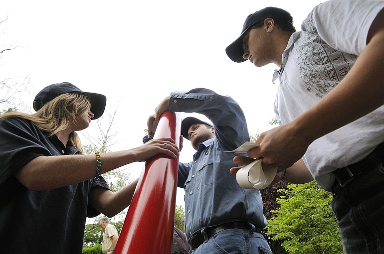
Sea Scouts, from left, Savannah Rova, 15, Taylor Torri, 17, and Ben Fillinger, 17, attach reflectors to new channel marker buoys. The buoys will be anchored along the tricky rock channel at the Heritage Park boat ramp on the east end of Lacamas Lake.Photo Gallery
With boating season at hand, the Marine Patrol unit of the Clark County Sheriff’s Office will mobilize its boats, including powerful personal watercraft and a twin-engine 24-foot cabin cruiser that can reach 50 mph.
Seven days a week, they will patrol an area that includes the Columbia River and the North Fork of the Lewis River system, including Lake Merwin and Yale Reservoir. They’ll look for safety violations including drunken boaters and can make rescues when needed.
The unit has had two full-time deputies, Todd Baker and Dave Nelson, but once school’s out, several deputies who serve as school resource officers will join them.
–John Branton
o LOCAL SEA SCOUT units in the Vancouver-Portland area are welcoming new members, male or female, ages 14 to 20. Sea Scouts learn sailing, boat operation and maintenance, seamanship and other skills. Call Jim Larsen, 360-921-8894, or visit http://www.joinseascouts.com.
With boating season at hand, the Marine Patrol unit of the Clark County Sheriff's Office will mobilize its boats, including powerful personal watercraft and a twin-engine 24-foot cabin cruiser that can reach 50 mph.
Seven days a week, they will patrol an area that includes the Columbia River and the North Fork of the Lewis River system, including Lake Merwin and Yale Reservoir. They'll look for safety violations including drunken boaters and can make rescues when needed.
The unit has had two full-time deputies, Todd Baker and Dave Nelson, but once school's out, several deputies who serve as school resource officers will join them.
--John Branton
o BOAT SAFETY CLASSES are offered by volunteers with U.S. Coast Guard Auxiliary, Flotilla 73, and the Fort Vancouver Sail and Power Squadron. The auxiliary has a four-part class that begins at 7 p.m. July 7 at 2929 N.E. Marine Drive, Portland. The two-hour Wednesday evening sessions cost $10, for the book, and are Washington and Oregon certified. Call Kenneth Babick at 503-348-6686.
CAMAS — Unless you’re in a kayak, you’re likely to bang up your boat and its propeller as you leave the Heritage Park boat ramp at the east end of Lacamas Lake in Camas.
There’s a wicked dog-leg rock channel to deal with as you head west to the main part of the lake. One boater commented that “trial and error, mostly error,” is how folks learn to negotiate it.
“It’s been an issue for years and years and years,” said Deputy Todd Baker with the Marine Patrol unit of the Clark County Sheriff’s Office.
All that could change June 19, thanks to Lou Kobet, 67, a Camas retiree who decided to make marking the channel a personal goal.
June 19 is the day the Marine Patrol and a group of Sea Scouts with the local Deja Vu unit plan to install several colored buoys, some red and some green, to mark the safe channel.
Once that’s done, lake boaters can use the old marine rule, “red right returning from the sea,” which also is used to mark the Columbia River’s deepwater shipping channel.
In other words, boaters should keep the red buoys on their right when returning from the main lake to the boat ramp.
When you’re heading out to the main lake, it’s the opposite. Keep the red buoy on your left and green on your right.
That should help, but such buoys serve as a guide only, Kobet said: “Buoy positions can change due to being dragged by boaters. Buoys do not indicate lake water depth. The lake level changes significantly, and without notice, throughout the year.”
Kobet coordinated this year’s marker-buoy project with Deputy Baker and the Sea Scouts.
He figured four red and four green buoys would cost more than $900, so he approached 14 businesses and asked for donations.
Several businesses donated money or materials, and Kobet spent a couple hundred dollars of his own, but there still wasn’t enough to purchase ready-made buoys.
o LOCAL SEA SCOUT units in the Vancouver-Portland area are welcoming new members, male or female, ages 14 to 20. Sea Scouts learn sailing, boat operation and maintenance, seamanship and other skills. Call Jim Larsen, 360-921-8894, or visit http://www.joinseascouts.com.
o BOAT SAFETY CLASSES are offered by volunteers with U.S. Coast Guard Auxiliary, Flotilla 73, and the Fort Vancouver Sail and Power Squadron. The auxiliary has a four-part class that begins at 7 p.m. July 7 at 2929 N.E. Marine Drive, Portland. The two-hour Wednesday evening sessions cost $10, for the book, and are Washington and Oregon certified. Call Kenneth Babick at 503-348-6686.
So Kobet thought of local scouts, who could use the experience for an Eagle project.
He contacted Sea Scouts in the area and several decided to take on the job of assembling the buoys.
Now they’re in business for the June 19 installation.
Kobet has “done a good job coordinating it all,” Baker said.
It’s not the first time Kobet has tried to help his fellow boaters at Heritage Park. In the first effort, he built some buoy anchors, which are five-gallon buckets filled with 100 pounds of concrete that have a a chain leading up to attach to the buoys.
Last November, Baker and sheriff’s Sgt. Fred Neiman installed the anchored buoys on some of the sometimes submerged rocks.
Even after that, however, a boater complained of banging up his boat on the rocks.
The problem: The rock-warning buoys “don’t tell you what side of the buoy to pass on,” Baker said.
The new colored buoys aren’t going to be foolproof, but they should help.
It all started when Kobet wanted to take his prized 13-foot, one-person sailboat through the passage. But he realized that the boat, with its keel filled with lead ballast, needs three feet of water to float.
With no marker buoys, he’d knew he’d just bang it up.
A retired process engineer, Kobet approached the problem scientifically. He stopped by the channel when the water level was drawn down several feet and took photos of the rocks that normally are barely submerged, to map them.
Tip: you can interact with this map using your
fingerscursor (or two fingers on touch screens)cursor.
Map
Looking for some official help, Kobet ended up talking with Baker.