The Forest Service is resuming its effort to complete a trails plan for the popular Coyote Wall-Catherine Creek area in the Columbia River Gorge National Scenic Area.
The agency has revised its leading alternative for the hiking, mountain bike and equestrian spot east of Bingen and gathered public comment at a meeting last week in Hood River, Ore.
The Forest Service owns almost 4,700 acres in the Burdoin Mountain, Coyote Wall and Catherine Creek areas of western Klickitat County. It is a gorgeous area with
a dry climate, low elevation, stunning views, wildlife and spectacular blooms of lupine and balsamroot in the spring.
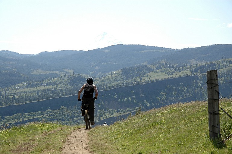
It is very popular with hikers and mountain bike riders, particularly in winter and spring when other areas are too wet or under snow. Hunters use the area in the fall, plus there are inholdings of private property.
But the area is crisscrossed with trails, at a density of about four miles per square mile of land. Some of the trails go on private land, and there is soil erosion in places.
The agency started a formal planning process for the area in 2007 and issued a decision last spring, said Greg Cox, scenic area assistant manager. Five legal appeals were filed, dealing with horse use in sensitive botanical areas, unleashed dogs, enforcement and parking.
The plan was withdrawn with a goal of working with the appellants to resolve their issues, said Stan Hinatsu, scenic area recreation manager.
There are 37 miles of trails, a combination of old roads and routes created by users of the area.
“A lot of those routes are not sustainable, and they show it,’’ Hinatsu said.
The revised alternative still cuts the trail miles from 36.95 to 26.44, but addresses some of the appeal issues.
Changes in the revised alternative include:
• Horse use will not be allowed in the lower Catherine Creek area. A loop trail on upper Tracy Hill will be open only from May through November.
Equestrian use will be limited to 115 horses a year with a maximum party size of eight horses a day. There will be no horse use east of Catherine Creek on lower loop trails.
Hinatsu said the lower Catherine Creek area is the most sensitive botanically. The 115 horses is the Forest Service estimate of current annual equestrian use.
• Dogs will be allowed off-leash west of Atwood Road and the Bonneville Power Administration lines, but must be leashed to the east.
• A proposed parking lot on Upper Courtney Road is being dropped. The need for more parking will be analyzed later.
No mountain bikes will be allowed east of Atwood Road. That is an area traditionally used by hikers, and the goal is avoid future conflicts, Hinatsu said.
Steve Watrous of Vancouver, one of the five appellants and a co-owner of almost eight acres of inholdings, asked why dogs must be leashed on the east side of the Forest Service land, but not the west.
He also voiced his concern about a lack of Forest Service enforcement of the plan.
Dan Carey of Camas, also an inholder, asked about new trails being developed by users of the area.
“What’s going to stop anybody from making more trails, more connectors?’’ he asked.
Hinatsu said new user-made trails will be closed. The Forest Service also will try to learn who made the new trails and discourage them, he added.
“It will take some effort to change behavior and change use patterns,’’ Hinatsu said.
Hikers, mountain bike riders and equestrians will be asked to prioritize routes as the Forest Service establishes a designated trail network, he said.
It will take five years or longer to get the network built, Hinatsu said.
The Forest Service next will issue a new environmental assessement, which is followed by a 30-day comment period. Then comes a new decision notice, followed by a 45-day appeal period.
Cox said making everyone happy is not possible.
“We want to come up with a recommendation that satisfies the diverse interests, yet is environmentally sustainable,’’ he said. “We’re not got going to satisfy everyone, but hope the plan stands the test of time.’’