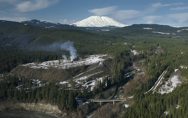
Starting in the late 1990s, a handful of developers eyed high-elevation timber land surrounding Mount St. Helens and saw opportunity.
They imagined upscale recreation “cabins” with stunning views of the volcano and access to fishing, hunting, snowmobiling, hiking and cross-country skiing.
With a world-renowned volcano in its back yard, speculators thought the property would market itself.
“Sloping to the northwest, virtually every lot will have unmatched views of Mount St. Helens a mere 3 miles away!” promised a 2005 sales brochure for Marbletop Retreat, 130 acres of high-elevation timber south of the volcano.
But today, 30 years after the eruption, those promises remain largely unrealized. Environmental concerns have cut short the most ambitious development plans. The recession has dampened the recreational real estate market. And it turns out that living on the flank of an active volcano isn’t very practical.
It now appears likely that most of the private land surrounding the mountain will remain in commercial forest use or return to the public domain, with only a few dozen private homes tucked into the forests south of the Mount St. Helens National Volcanic Monument.
An Olympic Peninsula timber company may someday build a resort with recreational housing near Swift Reservoir. But before that can happen, major investments will have to be made in roads and other infrastructure.
“We need to have a strategy for providing public services,” said Jon Rose, president of Olympic Property Group, the real estate arm of Pope Resources. “We have no idea what kind of scale is appropriate.”
Pope Resources has become a major player in the future of the Swift area. It is in negotiations with the Columbia Land Trust to sell 3,000 acres outright and grant conservation easements on addition environmentally sensitive land to protect it from development.
“It is an area that is rich with recreation opportunities,” Rose said. “Targeting it as a place to do economic development for Skamania County makes sense.”
Land of opportunity
Post-eruption, the high-elevation country surrounding the mountain was unzoned and lacked services of any kind. Elk and deer were its main inhabitants.
Some of this timberland had been part of the Gifford Pinchot National Forest before Congress approved land swaps with Burlington Northern Railroad and the Weyerhaeuser Co. in the early 1980s to consolidate holdings in the new 110,000-acre monument.
Most of the 34,000 acres of private land between Swift Reservoir and the monument were accessible by state and Forest Service roads, except in winter. It was a place where large forested plots could be sliced into building lots with little government oversight, thanks to loopholes in state and county laws.
Brothers Dave and Jeff Creagan and their associate Jerry Sauer began buying industrial timberland north of the reservoir. They sold lots and built upscale houses on the north shore that came complete with their own electrical generators and water systems.
They also platted what they envisioned as a 200-house suburban-style subdivision on smaller lots near the confluence of Pine Creek, Muddy River and the Lewis River.
At the time, Skamania County placed no restrictions on development in the Swift area. But fish and wildlife biologists soon voiced concerns about the impact of development on elk wintering habitat and threatened bull trout in Pine Creek. And the Forest Service said it had no funding to maintain its roads for year-round access to remote properties.
In 2006, after approving 131 new building lots in the Swift area in six years, the county imposed a moratorium on new development. Interim zoning under a new comprehensive plan designates most of the area for commercial timber production and strictly limits residential development.
No new building permits will be issued for lots created after 2006, and no applications to convert forestland to other uses will be granted under the new zoning, according to county planning director Karen Witherspoon.
Steep slopes and washed-out roads have limited development in some areas where lots were approved before the moratorium went into effect. In all, only 10 recreational cabins have been built on pre-2006 lots. “They created the parcels, but it didn’t seem like they got developed,” Witherspoon said.
Ironically, the county’s restrictive new zoning makes those grandfathered building lots more valuable, said Century 21 real estate agent Nita Creagan-King, the mother of developers Dave and Jeff Creagan. She currently has 15 to 20 listings in the Swift area.
“Since Skamania County changed the zoning, you can’t develop small lots, so there won’t be any more like that,” she said.
Recreation sites
In contrast to the Swift area, the High Lakes area, in extreme northeast Cowlitz County and northwest Skamania County, is inaccessible except by Weyerhaeuser logging roads. In the early years after the eruption, the company gave hunters access to the land and stocked its five small lakes with trout for fishermen.
In 2007, Weyerhaeuser sold 4,100 acres including Elk, Hanaford, Forest and Lawn lakes, to logging contractor Kurt Erickson, who bought the property primarily to harvest and sell its noble fir boughs.
Erickson and his business partner Fred Wagner also hoped to make a profit selling 19 individual lots to snowmobilers and others who might want a campsite or rustic cabin to call their own. More than half those lots have been sold. But at an elevation of 3,800 feet, “No one wants to live up there,” said Olympia real estate agent Paul Valentine, who is handling the listings.
“There are no services,” Valentine said. “You own your camping spot.” Buyers also have access to the rest of the company’s High Lakes holdings.
In 2008, Les Cornwall of Kelso wrote a blizzard of letters trying to interest state agencies and land trusts in buying the land around the lakes for public recreational use. Two years ago, the Washington Department of Fish and Wildlife tried but failed to win a $556,000 federal grant to buy 240 acres around two of the lakes.
“The fact that we didn’t get the money doesn’t mean we won’t try again,” said Penny Warren, who handles land acquisitions for the agency.
An advisory committee that met for more than two years to discuss the future of Mount St. Helens proposed that the Forest Service consider buying back the High Lakes area.
Jessica Walz, conservation director for the Gifford Pinchot Task Force, says the owners are open to selling the lakes to preserve public access.
“We are still trying to find someone who is willing to purchase it,” she said.
Conservation efforts
The prospect of uncontrolled development around Mount St. Helens has spurred conservation groups to take action.
In April, the Columbia Land Trust announced that it had won a $6 million federal grant that will enable it to buy 3,000 acres of Pope land near critical bull trout habitat in three small streams south of the volcano, including a tributary of Pine Creek.
Days later, the trust announced another $2.5 million grant that will allow it to buy a permanent conservation easement on Pope land to help stave off future forestland conversions if a deal can be reached.
Rose said the company’s goal is to retain 20,000 acres in timber production through federal incentives and build a destination resort with a lodge and recreational houses on the other 4,000 acres. To that end, he began discussions with Skamania and Cowlitz county officials last year about developing a Woodland-to-Cougar tourist loop that would draw people to the south side of Mount St. Helens to enjoy its many outdoor amenities.
Drivers can make the trip today when roads are snow-free, but the ride is rough in places. Between Carson and Cougar, tourist services are scarce or nonexistent.
“The goal is to build and develop something that would be a real showpiece for the Lewis River,” Rose said. “But there needs to be a consensus from the community and the commissioners that this an appropriate use for the location.”
Skamania County Commissioner Paul Pearce says the county is on board. It has applied to the federal government to designate 19 miles of the loop as a forest highway, the first step toward making road improvements that would make the loop more attractive to tourists.
“What we have said is that if this process goes through, the county will go ahead with development of resort zoning,” Pearce said.
Environmentalists remain cautious.
“We’re really concerned about developing the land around Mount St. Helens and adding more roads,” Walz said. “It’s really good elk habitat. A lot of people use it for outdoor recreation. This land isn’t important just to outside groups but to local groups. It’s important that it be returned to public hands.”