For a list of events marking the 25th anniversary of the Gorge National Scenic Area, go to http://www.gorge25.com.
Visitors to the Columbia River Gorge have the U.S. Forest Service to thank for the dazzling variety of recreation options available within a couple of hours’ drive from the Portland-Vancouver metro area.
A former historic homestead dotted with apple trees and once overrun with blackberries east of Washougal is now St. Cloud day use area, an oasis of quiet where visitors can picnic and walk along the Washington shore of the Columbia River.
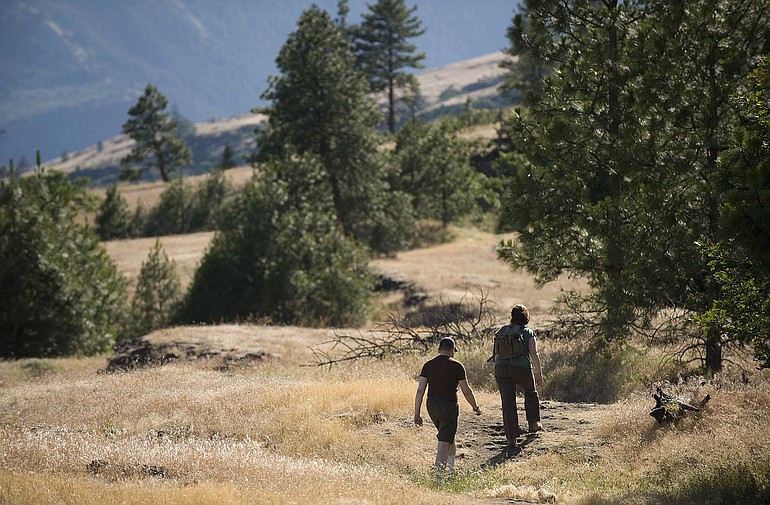
Hikers flock to Catherine Creek east of Bingen, a former cattle ranch, to photograph spring wildflowers and climb through open stands of Oregon white oak and ponderosa pine.
Cyclists and hikers travel two paved segments of Oregon’s old Historic Columbia River Highway, now a popular state trail that connects Hood River with Mosier and Cascade Locks with Bonneville Dam.
And a new, safer Cape Horn Trail, complete with tunnels under Highway 14, will greet hikers when it’s completed this fall.
Over the past 25 years, the Forest Service has polished the gem that is the Columbia River Gorge National Scenic Area.
Working with members of Congress from the Northwest and with public and private partners, the agency’s National Scenic Area office has invested $67 million in acquiring more than 41,000 acres of private land from willing sellers in the Gorge — 29,249 acres in Washington and 11,775 acres in Oregon. It’s restored hundreds of acres, including numerous rock and gravel pits and an unsightly trash dump near the mouth of the Klickitat River, now the Klickitat Balfour day use site.
The Forest Service has enhanced rare oak woodlands on both sides of the river through selective logging of Douglas fir. It’s in the process of restoring the Sandy River Delta near Troutdale, Ore., formerly owned by Reynolds Aluminum Co. and heavily grazed by cattle for years. It’s removed an airstrip from the Rowena Plateau on the Oregon side. And it’s built miles of trails, including a 13.5-mile section of a former rail bed, now the Klickitat Trail, which connects the communities of Lyle and Klickitat along the Klickitat River.
At the same time, the agency has scrambled to keep up with the demand for recreation in the Gorge, from hiking and sailboarding to mountain-biking and rock-climbing, while protecting fragile cultural sites, native plants and other features from damage.
The Forest Service estimates that national forest sites in the scenic area get about 2 million visitors annually, but that doesn’t count visitors to state parks, Skamania Lodge in Stevenson or the Gorge Discovery Center in The Dalles, Ore., or motorists just passing through.
Close to home
Because the population of the Portland-Vancouver metro area continues to grow, recreation use in the Gorge also is growing, particularly at a time when many people are short of both time and money, said scenic area recreation manager Stan Hinatsu.
“The Gorge is uniquely positioned, with easy access. It’s a quick easy trip from Portland or Vancouver,” Hinatsu said. “We’ve found that a lot of barriers to recreation are time and distance. If you’ve got to travel two hours to go for a hike, you’ll be less likely to do that. But the Gorge overcomes those barriers.”
Balancing increased recreation use with protection of fragile areas in the Gorge is an ongoing challenge for the agency.
Dan Harkenrider, scenic area manager since 2000, is retiring this summer, leaving to his successor the continuing challenge of striking that balance.
At a recent meeting of the Columbia River Gorge Commission, he said the agency will soon introduce a program called “Valuing Place,” an effort to define the concept of sustainable recreation in the Gorge.
“We want to understand better what connects people to places, and to help people understand the resources and values that public lands provide,” Harkenrider said. “The Columbia River Gorge is clearly a special place. Two million people visit Multnomah Falls alone annually. The Gorge draws tourists from other nations.”
One challenge heavy recreation use has intensified is unauthorized trail-building, especially on formerly private lands acquired by the Forest Service.
With 41,000 acres of new public land, “we’re seeing impacts,” Hinatsu said. “Cape Horn is an example of that. It was all private land, then it was public land, then someone built illegal trails.”
At Catherine Creek, the Forest Service has had to figure out how to keep users from damaging the very resources they came to enjoy. Before it was acquired for public use, it was a maze of informal trails.
“We are identifying the trails we want to keep and getting rid of the ones that aren’t sustainable,” Hinatsu said. “There are sensitive resources, there’s wildflower viewing. Will horses be allowed? How far should mountain bikes go? It’s that whole collision of social and natural resources.”
At Multnomah Falls, Oregon’s most-visited natural attraction, the Forest Service made a deliberate decision not to increase parking despite the hordes of visitors who jockey for parking spots on summer weekends.
“We figured 1,500 people at one time was about all that place could handle,” Hinatsu said. To protect habitat for anadromous fish, the agency also decided to close access to a pool at the base of the falls.
Solitude can be hard to find at waterfall areas along the Oregon side and at popular Eagle Creek, near Bonneville Dam. Hinatsu said surveys show people who visit those places don’t seem to mind.
“The waterfall corridor is an attraction in itself, more like a national park,” he said. “The Washington side tends to be a more traditional national forest experience, more dispersed, but that’s where we are seeing most of the impacts on new public lands. We haven’t had the resources to post all of our boundaries. We’ve produced a forest map that shows the most recent land ownership, but people have to be careful that they aren’t trespassing on private land.”
Watchdog role
The 1986 Scenic Area Act gave the Forest Service other roles in the Gorge besides buying land and managing recreation. Its employees were the first on the scene after the act was passed. They had the unenviable job of enforcing interim development guidelines and telling Gorge residents they couldn’t develop their land.
“It was a firestorm, especially on the Washington side,” recalled Jurgen Hess, a member of that first group, who later became the Forest Service’s scenic area landscape architect. “We had bomb threats at our office. We told our staff after meetings to check their vehicles. That first year, there was so much animosity and vitriol, it was kind of scary.”
The Gorge Commission eventually took over management and enforcement of the act in most of the scenic area. But the Forest Service continues to regulate development in the visually sensitive special management area, where it also regulates logging on private land to minimize its impact.
It’s also is expected to evaluate and comment on whether proposed federal projects in the national scenic area are consistent with the goals of the act.
Harkenrider has caught flak for fulfilling that responsibility.
In 2002, he notified the Bureau of Indian Affairs that the proposed conversion of 175 acres east of Hood River to trust land to allow the Confederated Tribes of Warm Springs to build a casino there would violate the act by exempting those lands from protection. The BIA disagreed.
In 2009, he wrote to Washington’s energy facility siting agency warning that a proposed wind project in Skamania County, just outside the scenic area boundary, would be visible from several key vistas in the scenic area, and suggested that some of the turbines be eliminated from the project.
That incurred the wrath of Jason Spadaro, president of Broughton Lumber Co., the developer of the project, and then-U.S. Rep. Brian Baird, who demanded that Harkenrider retract the letter. He didn’t.
Forest Service officials prefer to accentuate the positive. They worked with Skamania County to develop Skamania Lodge, and with The Dalles to develop the Gorge Discovery Center. Each project received $5 million in federal appropriations as part of the scenic area act.
Skamania Lodge “has been a tremendous success for the Gorge,” Hess said. “One of my biggest disappointments was that the Discovery Center has never taken off. The people who manage it have not figured out a marketing strategy.”
Art Carroll, who served as scenic area manager from 1991 to 2000 and now sits on the Discovery Center board, agreed, in part.
“The numbers that were used to project the visitation that was going to occur weren’t realistic to begin with,” he said. “They were based on people stopping off from Interstate 84.” Few freeway travelers do. However, the Discovery Center is working with wineries in the mid-Gorge to host a wine festival in October, Carroll said. Wineries are part of a burgeoning upscale tourism sector in the scenic area, especially in Hood River and western Klickitat counties.
Exploring the Gorge
Still, most visitors who come to the Gorge come for the waterfalls, sweeping vistas, steep trails, and world-class windsurfing and kite-boarding.
Friends of the Columbia Gorge organizes hikes from mid-March through mid-July and again from mid-September through October. The hikes, led by volunteers, focus on the natural history and wildlife of the Gorge and often include talks by naturalists, said Megan Jossy, outdoor programs manager for Friends.
A 10-mile hike to the top of Table Mountain “offers fantastic views of the Bonneville slide,” which tumbled off the mountain in about 1450, blocking the Columbia River and creating a natural bridge at the site of what is now the Bridge of the Gods.
In early spring, Jossy said, “we start in the eastern Gorge and follow the wildflower bloom westward.” This winter Friends brought a bald eagle expert to the Balfour Klickitat day use area, the wintering site of the largest concentration of bald eagles within a 200-mile radius of the Portland-Vancouver area. Eighty people showed up over two weekends to see the eagles.
“We have education themes to our hikes,” Jossy said. “Our outings are about more than witnessing the beautiful scenery. We’re teaching on the trail as well.”
In honor of the scenic area’s 25th anniversary, Friends is challenging hikers to visit 25 Gorge trails this year. About 150 people have pledged to hike all 25.
The variety of landscapes now accessible on the Washington side of the Gorge comes as a surprise to many hikers, including Jossy, who grew up in the Northwest.
“I really thought I knew the Gorge, but there’s so much to explore,” she said. The Klickitat Trail, built by the Forest Service, the Washington parks department and volunteers, which climbs the green Klickitat River canyon and crosses to the Gorge’s arid east side, is a new favorite,
“We offer at least one or two hikes there every season,” she said. “It is a gem.”
Kathie Durbin: 360-735-4523 or kathie.durbin@columbian.com.