The volcano’s catastrophic eruption happened 31 years ago today; 57 people were killed.
Green River among “10 most endangered”
More information on Mount St. Helens’ May 18, 1980, eruption and the decades that followed:
Mount St. Helens has been mostly quiet since its most recent dome-building eruptions ended in January 2008. But scientists say it’s a sure thing the volatile volcano in our backyard will reawaken.
The question they hope to answer is when.
Clues to the volcano’s future lie in the faint signals of magma moving in a cigar-shaped chamber deep within the mountain, in the eruptive history of a similar volcano on Russia’s remote Kamchatka Peninsula, and in the long geological record contained within Mount St. Helens itself.
Cynthia Gardner, a scientist at the U.S. Geological Survey’s Cascades Volcano Observatory in Vancouver, predicts the mountain will resume rebuilding itself sooner rather than later.
“Mount St. Helens will probably erupt again within the next several decades,” she says. “As we look at its eruptive history, we know there was a flank collapse 2,500 years ago. We saw the cone rebuild itself over a century or a century and a half.”
Yet since the 1980 eruption, she said, the mountain has rebuilt only 7 percent of its pre-eruption mass. “If we look at patterns from St. Helens’ past history, and from volcanoes around the world, we come to the conclusion we are likely to see more eruptions.”
Mapping the mountain
Michael Clynne, a USGS scientist based in Menlo Park, Calif., has studied Mount St. Helens up close since 1997. He’s making a geological map of the area and visits the volcano every summer, climbing to the crater rim, camping out on the mountain’s flanks, walking around on its deposits, and collecting rocks.
Back in his lab, the rocks are sliced thin, studied under powerful microscopes and dated using radiocarbon dating or, for rocks older than 20,000 years, argon dating. They hold a record of volcanic activity stretching back thousands of years.
The rock specimens document that the explosive 1980 eruption, triggered by an earthquake and the largest volcanic landslide in history, was part of a cycle that has repeated itself over millennia. The pyroclastic flows of superheated gases, the debris flows and the ash deposits that instantly transformed the landscape were nothing new. In fact, the serene symmetrical peak that blew its top in 1980 is the product of a long, violent history — a history that is still being written.
“Twenty-two hundred years ago, there was a much bigger collapse on the south side of the mountain that dammed the Lewis River,” Clynne said. “Most of those deposits lie beneath Lewis River reservoirs now, but you can see the evidence around the reservoirs, in breakout lahars.”
Spirit Lake, displaced by the collapse of the north flank of the mountain in 1980, was created by the damming of the North Fork of the Toutle River about 3,900 years ago, Clynne said.
“There were big eruptions that blocked the Toutle River in the earliest part of the Spirit Lake stage” he said. “The lake has been created and destroyed several times. There have been big floods down the Toutle River several times in the past thousands of years, caused by the breaching of temporary lakes.”
Two big floods that occurred in the Pine Creek period, some 2,900 to 2,550 years ago, “may have been precipitated by the collapse of lava domes,” he said.
Based on his research to date, Clynne doesn’t expect another explosive eruption like the one in 1980 anytime soon.
“That eruption was caused by an accumulation of gas-rich magma,” he said. “That magma takes decades to centuries to accumulate, so typically, the mountain cannot have another of these eruptions in the near future. What happens next is that there is lots of magma left in the chamber, but it’s gas-poor. You get dome eruptions for decades to centuries.”
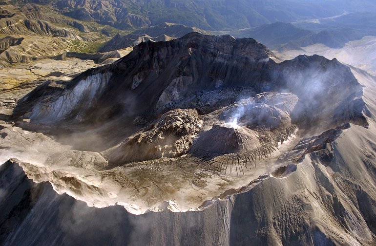
From late 1980 to 1986, Mount St. Helens spewed lava sporadically, building a lava dome that grew to a height of about 1,000 feet and a width of 3,500 feet. That was followed by a period of quiescence that lasted until 2004, when dome-building resumed.
The rock that emerged from the magma chamber during the 2004-08 period was composed of high-silica, gas-poor andesite and dacite.
“The lava comes out of the ground almost solid,” Clynne said. “It is not able to flow. It piles up right over the vent, then sort of falls over. It will do this again with gas-poor magma over the next few decades, until it gets a new load of gas-rich magma.”
“We have no way of knowing when the next batch of dacite will emerge,” he said. “When enough of it melts to separate, to become buoyant, it will come up the conduit to the shallow chamber.” That chamber lies five to six kilometers beneath the mountain and measures about one kilometer across.
“When you get enough gas-rich magma at the top, that’s when it erupts.”
In Clynne’s geological map, the entire edifice of the volcano and its flanks will be portrayed — a profile of Mount St. Helens through time.
The truncated mountain “will become a peak again,” Clynne said. “We can’t really say if it will be beautiful and symmetrical again. It depends on the kinds of eruptions and where the vents are. If it continues to build the way it is now, it will eventually fill the crater and reshape itself. That requires that we don’t have another collapse.”
Listening for magma
Tracking that flow of magma is a challenge, says Mike Lisowski, a geophysicist at the Cascades Volcano Observatory. With the help of sophisticated sensors, he studies the deformation of the mountain, looking for signals that magma is recharging within the volcano.
Mount St. Helens is one of two Cascade volcanoes being closely monitored by the Plate Boundary Observatory, a National Science Foundation-funded research project that studies movement between the Pacific and North American tectonic plates. (The other peak is Mt. Shasta in northern California.)
The program has installed 30 GPS units on Mount St. Helens and out to a distance of 20 miles from the mountain. Tiltmeters on the flanks of the mountain also detect changes in its shape, known as deformation.
“It’s a pity that the Plate Boundary Observatory instruments weren’t put in earlier,” Lisowski said. “It would have been great to have had them in 2004.”
So far, deformation of the mountain due to the movement of magma is “barely perceptible,” Lisowski said.
“During the whole eruption period from 2004 to 2008, the site at Johnston Ridge Observatory moved toward the mountain by just one inch,” he said.
Yet there is movement of various types.
“When we look at sites all around the mountain, we see that they are all moving toward the mountain,” Lisowski said. “Also, there is a downward motion that indicates that somewhere deep inside the volcano, magma is being withdrawn. It’s deflation, like with a balloon. The walls of the balloon get smaller. The crust surrounds the balloon.”
Other things are going on beneath the mountain, as well.
“There’s background tectonic movement,” Lisowski said. “Everything is moving to the north-northeast.” Slow-motion underground earthquakes known as “slip events” occur when the Pacific plate slips beneath the North American plate.
“They aren’t releasing tremors, but they do cause movement,” Lisowski said. That makes it hard to detect deformation of the mountain itself. “We are looking for small volcanic signals in a background of tectonic events.”
A Russian ‘sister’
For a few years, geologists thought a remote Russian volcano called Bezymianny might hold the answer to the future of Mount St. Helens. The 9,453-foot peak erupted in a massive blast in 1956 that had a lot in common with Mount St. Helens. Bezymianny never stopped erupting during the following 50 years. By 2007, its lava dome covered most of the crater surface and poked well above the crater rim.
Both mountains are stratovolcanoes — mountains that build themselves with a series of eruptions spewing lava, ash, cinders and blocks.
The first sign that Mount St. Helens was reawakening in the fall of 2004 was the emergence of fire-red lava from within the crater. A week and a half later, on Oct. 1, the volcano shot a noontime blast of steam and ash into the sky. A new dome-building stage had begun.
Scientists looked to Bezymianny for clues to what might be next.
They calculated that the Russian volcano’s 50-year-old lava dome was at least 10 times the size of the 111 million cubic yards of material that piled up in the crater of St. Helens between 2004 and 2006.
John Pallister, a USGS geologist at the CVO, even speculated that the two mountains were “sister volcanoes,” and that if the eruption at Mount St. Helens were to continue indefinitely, in a few decades it would look a lot like Bezymianny.
That hasn’t happened. Dome-building activity at St. Helens stopped in 2008. The mountain did rumble to life briefly three months ago, on Valentine’s Day, with a 4.3-magnitude earthquake north of the peak, followed by more than a half-dozen smaller aftershocks.
But scientists said the seismic activity did not indicate that magma was rising within the volcano. Instead, they speculated that it might be a sign of post-eruption settling in the landscape surrounding the mountain.
Assumptions shaken
Research into the history of the volcano has shattered old assumptions, Clynne said.
“We used to think the volcano began 45,000 years ago. We started dating rock and found it really began 250,000 years ago.”
Mount St. Helens is by far the world’s most-studied volcano. That’s among its most important legacies, Clynne said.
“Mount St. Helens has renewed interest in volcanology all over the world.”
Kathie Durbin: 360-735-4523 kathie.durbin@columbian.com.