It’ll be nothing like the mighty, roaring Mississippi River wreaking havoc in the South, but the Army Corps of Engineers announced on Thursday that the Columbia River is on the verge of flooding.
In some places, it already has.
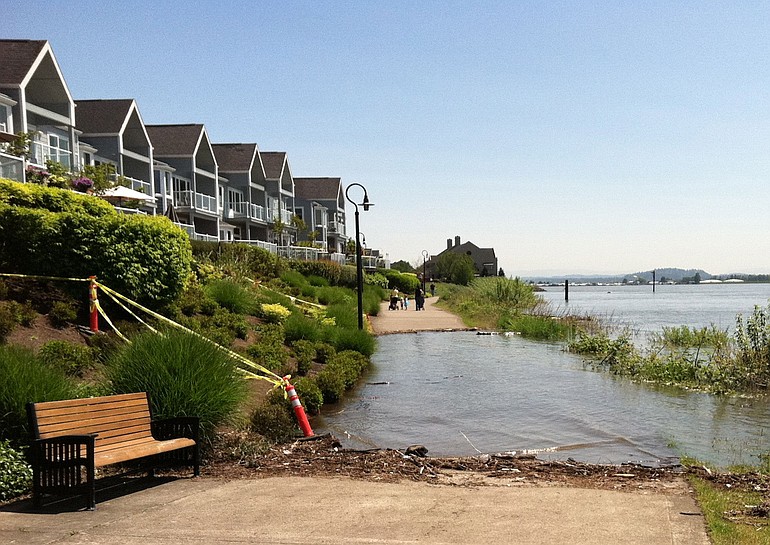
High water covered a portion of Vancouver’s Waterfront Renaissance Trail between the Interstate 5 Bridge and Beaches Restaurant & Bar on Thursday, interrupting some lunch-hour runs and prompting a few people to scramble up a hilly bank to get across. (The bank is private property and the property owners are asking the public not to do this, however.)
Mike Molchan stared at the water for several minutes before deciding to climb the bank.
“I’ve never seen it so high,” said Molchan, who’s lived in Vancouver for seven years. “It’s a ton of water.”
Were it not for steps taken by the Corps of Engineers, the river could be up to 3 feet higher, said Karl Canbergs, a team leader at the Corps’ Reservoir Control Center in Portland.
The John Day Dam, east of The Dalles, Ore., is capturing 100,000 cubic feet per second, he said. The Grand Coulee Dam and Dworshak Dam, in Idaho, are also taking up a lot of water.
The Corps of Engineers measures its flood stage at the Vancouver Harbor at 16 feet. As of 3 p.m., the water level there (not to be confused with the depth of the river) was at 15.97 feet above mean sea level, according to the National Weather Service.
In a hydrologic outlook, the weather service said the level in Vancouver will fluctuate about 6 inches during high tide, which typically takes place in the early morning and late evening.
To reach flood stage in Portland, the levels must rise to 18 feet, Canbergs said.
“The storage dams are doing their job,” Canbergs said. “We’ve just had a high water year.”
Water at the harbor is expected to push past the 16-foot mark by next week.
The technical flood is the result of cooler winter temperatures this spring that preserved until later in the year snowpacks 180 percent larger than normal in the Columbia River Basin.
“Everything considering, we’re in pretty good shape unless we have an unexpected rain event,” Canbergs said.
If the river remains less than 18 feet, any impact of the water’s climb into the flood stage is expected to be mostly minimal, evident only at river access areas, low-lying parks, on sidewalks and agricultural land. It will look a lot like what lunch-time visitors and residents near the Renaissance Trail were seeing Thursday.
Jane Tesner Kleiner of the Vancouver-Clark Parks & Recreation said crews started Wednesday night tending to high water at the trail, as well as the Tidewater Jetty, east of the Tidewater Condos, Vancouver Lake and sections of the Salmon Creek Trail.
“If we’re needing to put up barricades to let folks know of closures, we will,” she said.
Byron Hanke, whose Columbia Shores Condominiums home overlooked the flooded path on the Renaissance Trail, has seen the walkway flooded twice before.
“In ’96, the water was right to the edge of my deck, and the next year it was right about where it is now,” said Hanke, who purchased his condo when it was built in 1994.
In 1996, when snowpack statewide was actually below average, a warm weather system that melted heavy snow at lower elevations resulted in significant flooding and hundreds of millions of dollars in damage. That year, the river crested at 27.20 feet in Vancouver.
The Corps of Engineers doesn’t expect anything like that this time around. A key concern, though, is that families taking to the water for play over Memorial Day weekend will be unprepared for higher and stronger water conditions, Canbergs said.
The weather service warns: “Remember, all the rivers in the northwest are running very cold and swift. It is dangerous to try and swim in these waters.”
High water also means drivers should expect more Interstate 5 Bridge lifts to accommodate marine traffic.