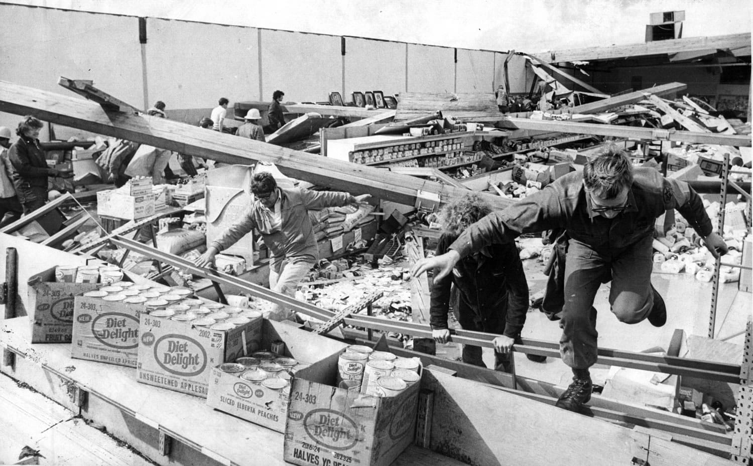
While tornadoes hit this region occasionally, the twister that struck Vancouver on this date in 1972 was unmatched for its toll on life and property.
It stands alone in generating wind speeds estimated at between 158 and 206 mph while staying on the ground for almost eight miles, Columbian weather blogger Steve Pierce said.
Killing six people, it was the most devastating tornado in the recorded weather history of Oregon and Washington, dating back to 1871.
It caused $5 million to $6 million in property damage in Vancouver alone, said Pierce, president of the Oregon Chapter of the American Meteorological Society.
“Unlike tornadoes east of the Rockies, tornadoes in the Pacific Northwest are often referred to as ‘cold core’ due to their lack of humid and buoyant air,” Pierce said. “The Pacific Ocean keeps our atmosphere relatively mild year-round. This is not conducive to the formation of super-cell thunderstorms needed to generate the really large and damaging tornadoes you might see in the Midwest.”
In Washington and Oregon, the twisters are generated by wind shears in lower levels of the atmosphere, regional weather official Steve Todd said.
Let’s say winds at the surface are from the south. And aloft, winds are from the west or southwest, said Todd, meteorologist in charge of the National Weather Service in Portland.
“Some instability moves over it, and it starts a rotation: a low-level shear that gets things spinning from the bottom, counter-clockwise rotations near the surface.”
Eventually, the whole spinning column lifts into the air, “and creates a little tornado,” Todd said.
“In the Midwest, tornadoes are formed aloft. You see it in the middle of the atmosphere, and it drops down,” Todd said.
Since 1887, the weather service has confirmed more than 70 tornadoes that have caused property damage, injury or death in Southwest Washington and Oregon, including three in Clark County.
The classification system has changed over the years. Tornadoes now are measured on a scale that goes from EF-0 (light damage) to EF-5 (incredible damage).
“The 1972 tornado was an F3, which is fairly close to today’s EF-3,” creating severe damage, Todd said.
Vancouver’s 2008 twister was an EF-1 tornado, creating moderate damage. In December 2010, an EF-2 tornado hit Aumsville, Ore., just southeast of Salem, creating considerable damage.
There have been a lot more tornadoes in the region, but they’ve been in remote or lightly populated areas.
Columbian archives include accounts of several twisters that touched down on farmland, churning up crops and knocking buildings off their foundations.
A clipping described a twister that damaged two farms near Ridgefield on Aug. 26, 1953: “All of the hens inside the chicken house escaped unscathed when the structure was picked up and slammed to the ground some 35 to 50 feet away.”
Other memorable wind storms
• Jan. 10, 2008: A tornado ranked as an EF-1 (on the EF-0 to EF-5 scale) originated near Vancouver Lake at 12:15 p.m. and churned through Hazel Dell, touching down for the last time about 10 miles to the east, near Hockinson. Damage was estimated at $500,000; no injuries were reported.n Dec. 12, 1995: Gusts topping 70 mph snapped dozens of trees and power poles, knocking out power to half the county’s 126,000 electricity customers. It caused an estimated $1.3 million in damage to public property and substantial damage to 31 homes. Damage was estimated at $35 million in nine other counties.
• Nov. 13, 1981: The “Friday the 13th” storm that raked Washington and Oregon generated winds up to 63 mph in Clark County, knocking out power to about half the county’s households. According to reports, at least six local people were seriously injured. Eleven people died in Washington and Oregon as a result of what became a series of weekend wind storms.
• Oct. 12, 1962: The Columbus Day storm killed three people in Vancouver and injured hundreds. Wind gusts reached 116 mph in Portland. At one point, a Chelatchie Prairie paper mill was the only Clark Public Utilities customer getting power — and its electricity was coming directly from Yale Dam. Two Vancouver residents were killed by falling trees; the third victim suffered a heart attack when a corner of her mobile home was knocked off its blocks. They were among 48 people who died as the storm cut a swath from Northern California to Canada.
• Jan. 15, 1951: Winds up to 68 mph knocked down power lines and toppled trees around the county. Thirteen schools were closed because of blocked roads and power outages. In a McLoughlin Heights housing project, a team of 150 carpenters repaired 240 dwellings that lost all or part of their roofs.
• Dec. 23, 1940: What news accounts called the worst windstorm in 20 years hit virtually every section of Clark County. The most spectacular damage came when it blew a galvanized iron roof measuring 12 by 40 feet off a downtown Vancouver industrial building. The 1-ton roof broke in two; one chunk fell on power lines and the other half landed on a nearby railroad track.