COUGAR — With the Muddy River roaring nearby, Matt Longhurst carefully climbed down the 31-rung steel ladder on Lava Canyon trail.
“It’s different,” said Longhurst of Puyallup. “It’s something I hadn’t come across yet in my short hiking career.”
Lava Canyon trail No. 184 in the Mount St. Helens National Volcanic Monument is a different sort of trail.
GETTING THERE: From Cougar in southern Cowlitz County, drive east on the Highway 503 spur and Lewis River road No. 90 for seven miles to the junction with road No. 83. Turn left and follow road No. 83 for 11 miles to its end at Lava Canyon trailhead.
GETTING THERE: From Cougar in southern Cowlitz County, drive east on the Highway 503 spur and Lewis River road No. 90 for seven miles to the junction with road No. 83. Turn left and follow road No. 83 for 11 miles to its end at Lava Canyon trailhead.
FEES: A Northwest Forest Pass is needed to park at Lava Canyon. The fee can be purchased on site for $5.
An annual Forest Pass costs $30 a year and covers most day-use fees on national forests in Washington and Oregon.
A Forest Pass also is needed at Ape Canyon, Ape Cave, Climbers Bivouac and Lahar Viewpoint all on the south side of Mount St. Helens.
It’s gorgeous. The strikingly clear water of the Muddy River cascades over six waterfalls, several of stunning beauty.
It’s dangerous. The trail is narrow in places and on the edge of a cliff in others. There’s a temptation to leave the safe route and cross smooth, but often wet, rock to get a better view of the falls.
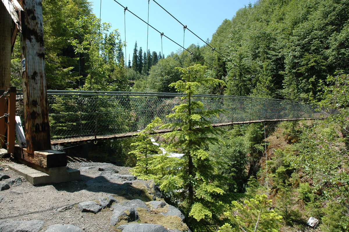
The trail packs in the waterfalls, a suspension bridge, the steel ladder and an odd rock formation named “The Ship” in just 3 miles on the southeast side of the volcano.
Lava Canyon was “created” in the massive May 18, 1980 eruption.
A surge of hot gas, ash and pumice boiled out of the crater and scoured nearly 30 feet of ice off Shoestring Glacier.
A 15-foot wall of mud and rock swept into Lava Canyon. The mudflow’s boulders and abrasive ash scoured away the forest, exposing the canyon, its waterfalls and rock formations.
Lava Canyon has six distinct waterfalls, according to “Waterfall Lovers Guide Pacific Northwest” by Gregory Plumb.
Most hikers don’t go any farther than the 1.3-mile loop created by trails No. 184 and 184A.
They see a lot and only lose and regain about 170 vertical feet from the trailhead.
But they miss a lot, too.
Downstream from the suspension bridge, the trail is for the sure-footed and hikers indifferent to heights.
Slightly less than a mile from the suspension bridge is the steel ladder, which solves the problem of getting the trail over a sharp drop-off.
At the base of the ladder is the massive rocky outcrop called “The Ship.”
Continue down Lava Canyon trail and soon a side trail turns right and climbs steeply to a viewpoint in 0.2 miles.
At two miles from the trailhead, Lava Canyon trail junctions with Smith Creek trail No. 225. Lava Canyon trail crosses the bridge and continues with a few small switchbacks to its end at road No. 8322.
There’s a flat used by campers at the lower trailhead.
An ideal way to hike Lava Canyon is to have two cars and walk it upstream from the lower trailhead.
Although hiking uphill seems counter intuitive, the views of Muddy River are better going up and the footing is less intimidating.
The Forest Service stresses safety on the route.
Bill Uyesugi of the monument staff said there have been at least five fatalities on the trail.
Four of the deaths were sons slipping and fathers trying to save them.
“Any time the rock is wet it’s slippery,” he said.
Pine Creek Shelter — For a short, interesting side hike, take the 0.45-mile walk to Pine Creek Shelter, built in 1921-22 and restored in 1991.
The trailhead is found on the north side of road No. 83 just east of the crossing of Pine Creek.
There’s only 100 feet of elevation gain. The shelter includes two platforms for bedding and a table under cover, plus a fire ring, two benches and a small wood shed.