Spokane — Heat, massive wildfires and violent thunderstorms: The summer of 2014 will be remembered for its intensity and disruption.
Climate scientists say it is also a look into the future.
Extreme temperatures and wildfires across the Pacific Northwest this summer are consistent with changes expected from global warming by the middle of this century, according to the 2013 report “Climate Change in the Northwest.”
“The warm conditions certainly are a harbinger of climate change,” said assistant geography professor John Abatzoglou of the University of Idaho, one of more than two dozen regional scientists who participated in the report.
In Spokane, the period from July 1 through Aug. 26 was the warmest on record.
The average temperature — a combination of daily highs and lows — was 74.5 degrees for those eight weeks. That is 4.8 degrees above normal for the period.
Abatzoglou said the 2013 report shows that the region’s summertime temperatures can be expected to warm by about that same amount by midcentury.
“At least in terms of temperature, this will be considered normal,” he said.
So far this year, Spokane has seen 26 days of highs of 90 degrees or hotter. That’s well below the record of 39 such days in 1958, but there was something else that stood out, said Ron Miller, science officer for the National Weather Service in Spokane.
Spokane saw 12 consecutive days of 90 degrees or hotter from July 6 through 17 and another string lasting 10 days starting on July 27. On July 29, the heat peaked at 100 degrees as measured at Spokane International Airport.
Those hot days came with warm nights, too.
Spokane set a record for 19 consecutive days with lows of 60 degrees or warmer. Global warming models predict that nighttime temperatures will rise during the summer.
Despite the records, the weather pattern that brought the heat is not unusual.
In most summers, high air pressure gets anchored over the desert Southwest and as the high builds northward, it allows equatorial heat to bubble up into the Northern Hemisphere.
What was unusual was the strength of the pattern, according to the National Weather Service.
At the same time, a low-pressure area in the Gulf of Alaska periodically sent weather disturbances southeastward.
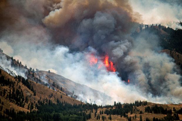
A series of damaging thunderstorms triggered huge wildfires, stirred winds to near-hurricane force and inundated parts of the landscape with heavy rain. The Carlton Complex of lightning-caused blazes ravaged 256,000 acres and destroyed 300 homes. It is the largest wildfire in state history.
As if that weren’t enough, a group of slow-moving thunderstorms Aug. 21 dumped so much rain on the fire scars that three small dams were breached, sending a damaging torrent down to the Methow Valley floor near Carlton.
In the aftermath of the flood, Jeff Lyman, owner of the Carlton General Store, posted this on his Facebook page: “I don’t know what Mother Nature is trying to tell us … but we are not giving up that easy! The more she throws, the harder we fight!!”
In a telephone interview, Lyman elaborated.
“It’s hard to fathom what has actually happened,” he said. “This is not going to deter us.”
Areas closer to Spokane and North Idaho saw their share of trouble, too.
Spokane International Airport measured one wind gust of 67 mph on July 23, the same day that power was lost to more than 60,000 homes and businesses by a cascade of falling trees that damaged or destroyed numerous homes, including a manufactured home park along U.S. Highway 2 in north Spokane County.
A second big line of thunderstorms Aug. 2 came like the rerun of a horror movie. Many of the same locations saw a repeat round of wind damage and power outages.
One of the people caught outdoors in the July 23 storm was Amy Snover, director of the Climate Impacts Group at the University of Washington.
She was visiting Spirit Lake in North Idaho with her family when the wind started ripping down trees. She said they ran to the beach to keep from being struck. “It was terrifying,” she said.
Snover was a lead editor of the Northwest climate change report.
She said scientists are not certain how global warming will affect the formation of thunderstorms, but they are studying that.
The main impacts revolve around hotter temperatures, less precipitation, less soil moisture, lower snowpack and higher fire risk, she said. The climate study examines the potential effects on resources, including forests, fisheries and agriculture.
“We expect we will have more of these extreme heat events,” she said. “Climate change raises the floor so you hit the ceiling more often.”
The increase in average temperature could be as much as 5.8 degrees from 1999 to 2050, Snover said. The summertime increase could be even greater.
If nothing is done to alter current population growth and energy use patterns, the temperature increases could be even greater, she said.
“It depends a lot on the choices we make with greenhouse gas emissions and energy use,” Snover said.
The vast majority of scientists agree that human activity is impacting climate change. Those who reject human-caused climate change argue that natural cycles are the reason for global warming.
“Really, it’s a weather event,” said George Taylor, a former Oregon state climatologist and now a consulting meteorologist.
He said higher humidity levels were remarkable this year. Also, he believes urban development around established weather stations has caused increased temperature readings, not carbon dioxide and other greenhouse gas emissions.
Snover said she and other scientists acknowledge that natural cycles are part of the picture, but that the warming is occurring so rapidly that human activity is the only scientific explanation.
Ed Lewis, deputy director of the Spokane County Department of Emergency Management, said this summer underscores the need to be prepared.
Residents living in areas vulnerable to fire need to clear a “defensible zone” around their homes by pruning or removing trees; picking up limbs on the ground; and keeping 30 feet of open space or lawn around the dwelling.
By doing so, “you’ve given your home the opportunity to survive,” Lewis said.
In western Spokane County, a fire disaster was averted July 19 and 20 when crews rallied quickly to stop a 10,500-acre blaze.
“If you look at our history, wildfire events are part of the ecosystem and we are not immune,” Lewis said.
Abatzoglou, at the University of Idaho, said the most vulnerable part of the Inland Northwest landscape in coming years will be the transition zone between grassland and forest. Fire and insect infestations could be so devastating that natural ecology may not be able to re-establish itself.
“The east slopes of the Cascades are very vulnerable,” he said.
The forests of North Idaho are less threatened because rain and snowfall patterns should keep them relatively moist in coming years, he said.
In addition to fires, wind and inconsistent downpours, the heat this summer worsened a developing drought that now extends from the east slopes of the Cascades across the Columbia Basin to the edge of Spokane County, according to the U.S. Drought Monitor.
Wheat yields are down an estimated 30 percent, farmers reported.
Atmospheric sciences professor Cliff Mass of the University of Washington summed up the situation on his blog earlier this month. He compared this summer to a midrange scenario for global warming, and said “this is like advancing 30 to 50 years into the future.”
“So this summer you are getting an idea of the conditions you or your children will experience in approximately 2050.”