Where: Near Camp Sherman (across the Santiam Pass near Sisters in Central Oregon).
Trail distance: 5.4 miles.
Climb: Minimal.
Difficulty: Easy to moderate.
Small car access: Yes.
Fees: None.
Kid-friendly? Yes.
Dogs: Must be leashed.
Directions: About a two-hour drive from Salem. From Salem, follow Highway 22/20 over Santiam Pass a total of 98 miles. At a sign for Camp Sherman and the Metolius River, turn left onto Camp Sherman Road (1419) and follow it 5.6 miles. Continue straight on Forest Road 1420 for 3.3 miles. Turn right on Road 1420/400 toward Canyon Creek Campground to a parking area and marked trailhead.
Trailhead GPS coordinates: N44 30.054 W121 38.466
Quick hint: If you put the trailhead GPS coordinates into Google Map, on your computer, laptop, tablet or smart phone, you can navigate directly to the trailhead.
CAMP SHERMAN, Ore. — The color is difficult to describe.
In the shadows of the canyon, the water is a rich, dark blue, a stream of liquid ink rolling through a forest of burnt-orange ponderosa pines.
Where: Near Camp Sherman (across the Santiam Pass near Sisters in Central Oregon).
Trail distance: 5.4 miles.
Climb: Minimal.
Difficulty: Easy to moderate.
Small car access: Yes.
Fees: None.
Kid-friendly? Yes.
Dogs: Must be leashed.
Directions: About a two-hour drive from Salem. From Salem, follow Highway 22/20 over Santiam Pass a total of 98 miles. At a sign for Camp Sherman and the Metolius River, turn left onto Camp Sherman Road (1419) and follow it 5.6 miles. Continue straight on Forest Road 1420 for 3.3 miles. Turn right on Road 1420/400 toward Canyon Creek Campground to a parking area and marked trailhead.
Trailhead GPS coordinates: N44 30.054 W121 38.466
Quick hint: If you put the trailhead GPS coordinates into Google Map, on your computer, laptop, tablet or smart phone, you can navigate directly to the trailhead.
But in the groves where sunlight comes through, Oregon’s magic stream lights up with patches of azure and sapphire so clear they rival Crater Lake.
The Metolius River seems to celebrate every possible shade of blue during its journey from gushing springs at the base of Black Butte into the dry forests of Central Oregon.
The area surrounding the Metolius — centered on the tiny town of Camp Sherman — is a mecca for recreation, showcasing road biking, mountain biking, fly-fishing and numerous camping spots.
But perhaps no way is better for enjoying the stream’s wonder than a hike along the 15-mile Metolius River Trail.
Most people who explore this area hike to the Head of the Metolius, where you can watch the river’s spring-fed birth from a little platform. It’s a nice place, but there are far better views and less people downstream.
My favorite stretch of the trail begins at Canyon Creek Campground, about 5 miles from Camp Sherman, and follows the river through a deep valley to Wizard Falls Fish Hatchery during an easy out-and-back hike of 5.4 miles.
The trail begins at Canyon Creek on the West Metolius Trailhead.
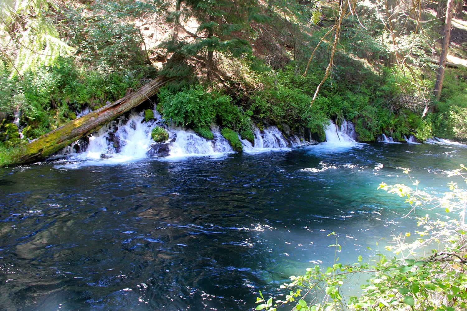
Follow the trail left, dropping around a bend and down into the canyon. After just 0.4 miles, the trail arrives at a spectacular springs, where water gushes into the Metolius from the hillside and there’s a wonderful place to sit and, if you’re brave enough, put your feet into the frigid water.
The river stays peaceful and pretty for the next mile or so, before the Metolius splits around a series of small islands. Many birds can be found in this area, including goslings, tanagers and water ouzels.
At mile 2.7, the trail stops at Wizard Falls Fish Hatchery, a place where trout and salmon are born and then stocked in lakes and streams around Oregon. You have many options at this point, but if you’re just here for a short and easy hike, turn around and head back to your car the way you came, enjoying every shade of blue that the Metolius River can offer.