NORTH BONNEVILLE — It’s not much of a peak, topping out at just a bit more than 1,100 feet elevation.
And it’s not much of a hike — just 1.8 miles one way to the top of Aldrich Butte.
But in this season of still short days and mostly lousy weather, the trip offers a decent backcountry experience from a relatively close-to-home drive.
Here are a trio of hikes — none particularly challenging — as March is here and the urge to get outside returns.
Aldrich Butte is a small peak north of North Bonneville. The hike starts at the gravel parking lot west of Bonneville Hot Springs Resort.
To make this hike, follow the road up the hill from the gravel parking lot on the west side of the resort.
At about 500 feet, come to a junction at a flat spot. Veer a few feet left (west) on this dirt road and you’ll spot a small trail sign “PCT 2.2, Table Mt. 4” posted on a tree on the uphill side of the road.
Follow the well-worn trail through the blackberries and into the forest. It will lead to Carpenters Lake at .99 mile.
At Carpenters Lake, which is just a grassy marsh area, you will junction with an old road. Turn right, then take the left fork and switchback quickly to another junction. Take the left again, climbing along the west side of Aldrich Butte to the summit.
At 1.4 miles a trail will veer off to the right, dropping into the valley of Cedar Creek. Stay left on the road to the summit at 1.8 miles.
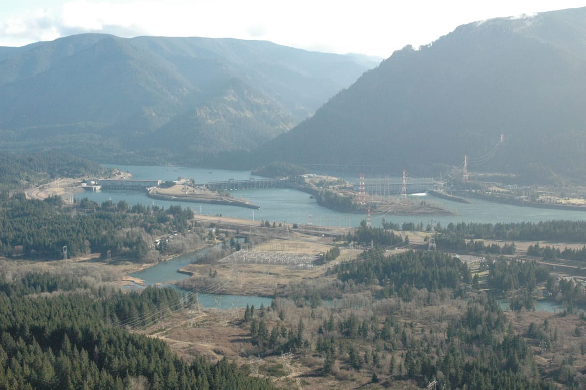
The route is open all year except maybe when ice storms hit the Columbia Gorge. Views of Hamilton Mountain in Beacon Rock State Park are available to the west.
Maps list the summit as 1,141 feet, while the GPS elevation said 1,166 feet. Either amount, it’s a steady climb from Bonneville Hot Springs.
There are concrete foundations left from an old building that make great seats at the viewpoint at the summit of Aldrich Butte.
The remains here are from when the location was used as a fire lookout and a defensive position during World War II for Bonneville Dam.
If you look back downhill, there is a short trail heading upward a few more feet to what appears to be an old gun mount.
A maze of old forest roads, railroad beds and user-made trails can be found in the area between Table Mountain and Hamilton Mountain in Beacon Rock State Park to the west.
Whistle Punk loop — 1.55 miles, elevation 1,139 feet, flat — This loop (Whistle Punk trail No. 59) wanders through a long-ago railroad logging site, passing remnants of timber-harvesting equipment and cables from the 1920s.
The short loop is .75 mile. Take the longer loop, which includes a boardwalk through a wetland. It’s flat, pleasant little walk that largely follows a 1913 railroad grade.
To find the trailhead, go the junction of the Wind River Highway and Hemlock Road at the community of Stabler. Turn west on to Hemlock Road and go 1.3 miles just beyond the former Wind River Work Center. Turn right on road No. 43 at Hemlock Recreation Site and go 0.6 miles to the junction with road No. 4300417.
Turn right on to No. 417 and follow it 0.4 miles to the trailhead, which includes a restroom and picnic table.
Bunker Hill trail –3.4 miles; bottom elevation, 1,200 feet; top elevation, 2,400 feet — To find the trailhead for Bunker Hill trail No. 145, follow the directions for Whistle Punk. Once on road No. 417, go only 0.1 mile to a crossing of the Pacific Crest National Scenic Trail.
Bunker Hill is a free-standing little mountain on the edge of the old Wind River Nursery.
The trail to the top is steep grind through the trees with little to see except one semi-panoramic view down the Wind River valley from near the summit.
From road No. 417, follow the Pacific Crest trail east for a half mile to the junction with trail No. 145.
At the junction, trail No. 145 up Bunker Hill heads left while the Crest trail drops to the right.
Bunker Hill trail makes 11 switchbacks as it ascends the mini-peak. At the top are concrete footings of a former fire lookout station. The station was built about 1940 and abandoned in the 1950s.