Dog Mountain
General location: Washington side of Columbia River Gorge, near Stevenson and Bridge of the Gods.
Distance: 7-mile loop.
Climb: 2,850 feet of gain.
Difficulty: Strenuous.
Route: From trailhead, follow Dog Mountain Trail, taking the “less difficult” option, to the upper summit meadows. On the way down, follow Augspurger Mountain Trail back to the trailhead.
Directions: Head east on state Highway 14, passing Stevenson, to between milepost 53 and 54; the trailhead is on the left. The trailhead is huge and impossible to miss.
Coordinates: N45 41.951, W121 42.545.Hint: Input the coordinates into Google Maps on your iPhone or tablet device to navigate directly to the trailhead.
Dog Mountain
General location: Washington side of Columbia River Gorge, near Stevenson and Bridge of the Gods.
Distance: 7-mile loop.
Climb: 2,850 feet of gain.
Difficulty: Strenuous.
Route: From trailhead, follow Dog Mountain Trail, taking the "less difficult" option, to the upper summit meadows. On the way down, follow Augspurger Mountain Trail back to the trailhead.
Directions: Head east on state Highway 14, passing Stevenson, to between milepost 53 and 54; the trailhead is on the left. The trailhead is huge and impossible to miss.
Coordinates: N45 41.951, W121 42.545.Hint: Input the coordinates into Google Maps on your iPhone or tablet device to navigate directly to the trailhead.
STEVENSON — To climb Dog Mountain during the height of wildflower season is to experience the very best, and very worst, of the Columbia River Gorge all at once.
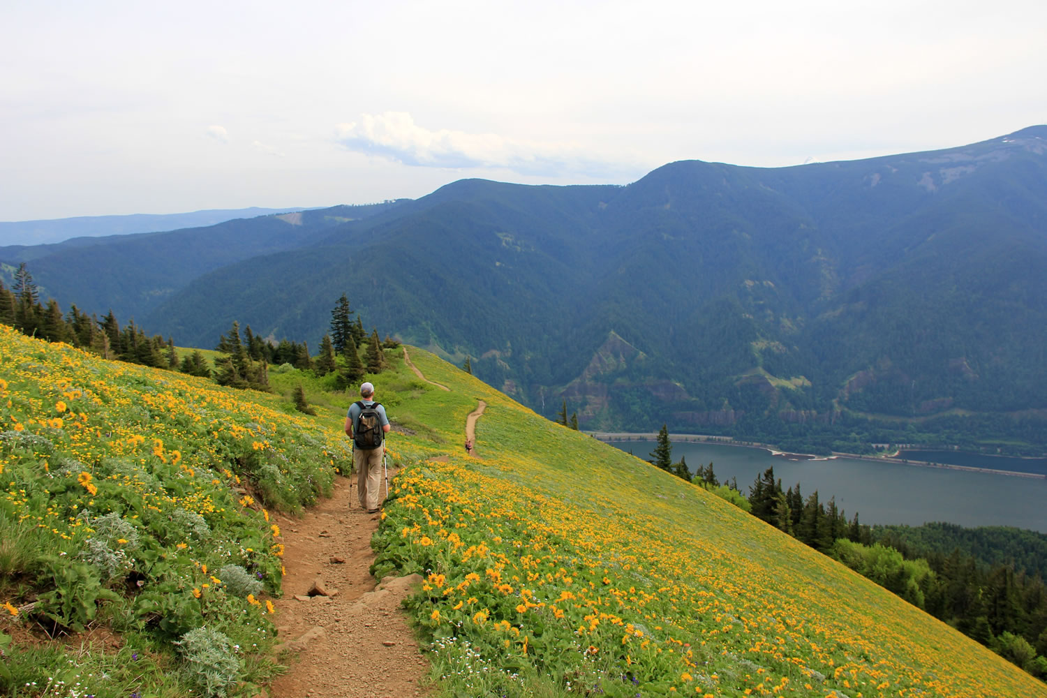
The meadows of this mountain east of Stevenson light up with red paintbush, blue lupine and such a thick carpet of yellow balsamroot that it feels as though you’re walking in fields of gold high above the Columbia River. Throw in views of Mount St. Helens and Mount Hood and — despite a steep and difficult hike — you have an earthly paradise for a few weeks each year in late May and early June.
In other words, right now.
Problem is, this trail is not some hidden gem or well-kept secret. The easy access and well-deserved fame lures a sizable chunk of Portland and Vancouver’s 2.2 million citizens, turning the trail into a shopping mall staircase on sunny weekends.
You’ll meet packs of unleashed dogs, cellphone photographers around every corner and hoards of fitness-focused 20-somethings on the 3-mile trek to the top.
A wilderness experience, in other words, this is not.
But just like traveling to Multnomah Falls, solitude isn’t really the point, and crowds of people are the price for profound beauty.
According to Greg Lief, creator of the website OregonWildflowers.org, the wildflowers should peak in the upper meadows this week — May 19 to 25 — and slowly decline during the next two weeks.
“The peak is a little earlier than normal this year — by about a week,” Lief said. “But even if you miss it by a week or so, you’re not going to mind because it’s still like walking around in a huge yellow carpet of flowers.”
So spotlight a time midweek — or get a very early start — to experience the stunning views and stunning crowds of what might be the Gorge’s best spring hike.
The hike
Dog Mountain Trail does not mess around.
The trail shoots uphill at a relentless grade, climbing 2,850 calf-burning feet on a hike best undertaken as a 7-mile loop.
Beginning on the side of Evergreen Highway 14 — east of Stevenson and the Bridge of the Gods — Dog Mountain Trail climbs a half-mile to one of the most honest trail junctions I’ve ever come across.
The trail splits in two here. A sign pointing left says “more difficult” while the sign pointing right says “less difficult.”
A person could go batty contemplating the implications of this intersection. Should I take the path less traveled? Prove myself by undertaking the tougher test?
The reality isn’t that complex. The “less difficult” option is just a newer trail with an easier grade and better views to boot. So unless you feel like punishing yourself for no good reason, go right.
The trail breaks into the open at mile 1.5, showcasing a lower meadow and a small taste of the wildflowers and views above. The lower meadow makes a good turn-around point for those uninterested in marching another 1,300 feet to the summit.
The next 1.5 miles continue the relentless uphill slog, mostly within second-growth forest where poison oak is abundant, until the trail breaks into the open and you reach the phantasmal golden fields of the upper meadows.
It’s difficult to overstate the spectacular nature — and the sheer size — of the upper meadows. Vast swaths of the mountainside are covered with balsamroot in meadows that hang over the top of the Columbia River.
A closer look at the meadows reveals flowers like baby blue eyes, cluster lilies, Indian paintbrush and desert parsley.
The summit is easy enough to find by following trail signs. There are nice places to sit and enjoy lunch, the views and the wildflowers. Once you’ve had your fill, I recommend a different route down to complete a 7-mile loop.
To save your knees and enjoy a less crowded descent, follow signs from near the summit to Augspurger Mountain Trail. The northwest route is a bit longer — four miles instead of three — but the trail less steep and arrives at the Dog Mountain Trailhead on the far side of the parking lot.
Dog Mountain isn’t a place you’re likely to find solitude, but for the next three weeks or so, it would be difficult to discover a place more stunning.