DALLESPORT, Wash. — The warbling of the meadowlark sounds welcoming and the showy yellow flowers of balsamroot have an inviting feel, too.
Add in the faint aroma of yellow parsley and it’s no wonder spring is the best of the seasons in the east end of the Columbia Gorge.
Six weeks from now, the landscape will have reverted to its typical collage of browns, beiges and grays.
But now, it’s balsamroot, prairie lupine, phlox and lush green grasses — a great time to hike the new 6.16 miles of trails at Columbia Hills State Park.
The Washington State Parks and Recreation Commission acquired Dalles Mountain Ranch in 1993, combined it with adjacent Horsethief Lake and Horsethief Butte, and renamed the 3,438 acres Columbia Hills State Park.
A low-budget planning effort began in the early 2000s involving mountain biking and horsemen’s groups to use existing livestock trails, game trails, two-track farm roads and a segment of the historic military road to develop a trail network.
A number of reroutes and design changes to protect sensitive locations resulted in the new trail system.
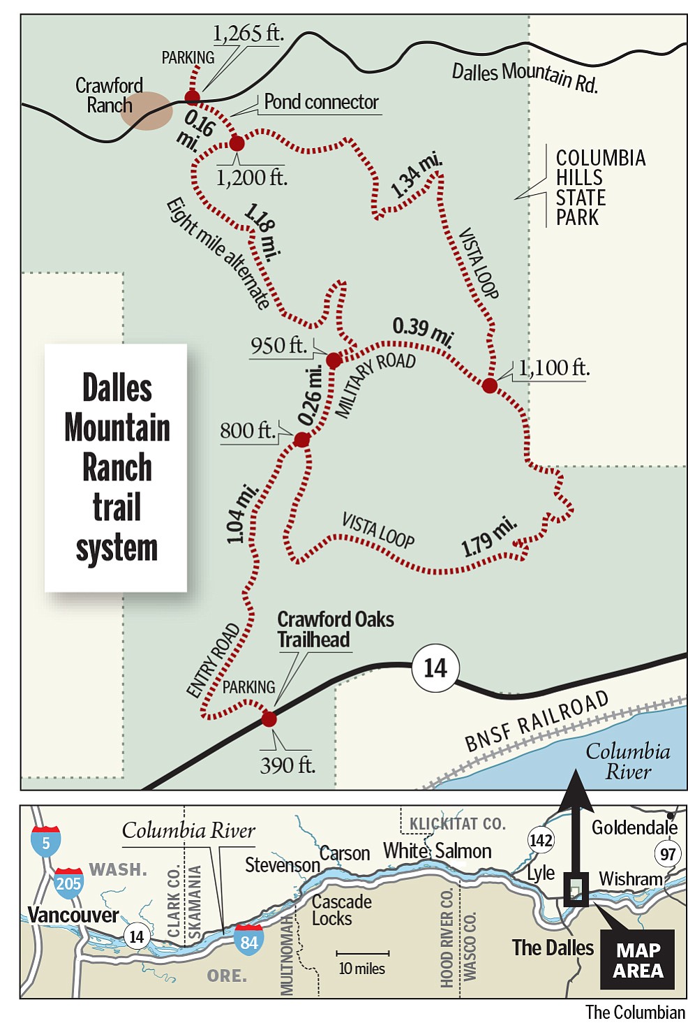
Crawford Oaks trailhead, just east of milepost 87 on state Highway 14, was built in 2013 using federal scenic highway and state Recreation Conservation Office grants.
The trails were built in late 2013 and early 2014 by parks staff and volunteers. The trailhead opened in late May of 2014, although after the spring green-up and wildflower bloom.
“We saw some discovery of the trails last fall, but it was fairly light,” said Andy Kallinen, assistant area manager for the state parks agency.
Besides the Crawford Oaks trailhead on state Highway 14, the trail network can be accessed by a higher-elevation trailhead 3.5 miles up Dalles Mountain Road.
The 6.16 miles are two connected loops. Vista Loop provides panoramic views of the Columbia River stretching from The Dalles to the mouth of the Deschutes River. Eightmile Alternate roughly parallels Eightmile Creek.
Total elevation gain from the lower to the upper trailheads is 875 feet.
Kallinen said the system is so new he has no evidence to say which portion of the trail routes is most popular.
The trails are open to hikers, mountain bike riders and horsemen.
Dogs are allowed, but must be leashed. Violation of the leash law is $87 per dog.
Hikers are using the trails most, at least so far.
“I’d estimate 10-to-1 versus bikes,” Kallinen said. “But I expect that ratio to narrow.”
Use by horsemen has been light.
“The horse community is pretty well informed, but it’s a much smaller user group,” he said. “Whereas, the biking community is everywhere and the word is spreading.”
Kallinen expects to see more mountain bike use in the September-early November time frame and again in late February through April.
“Cyclists will discover the more reliably dry conditions a bit farther east from the central Gorge corridor,” he added.
The upper loop may need to be closed to bikes and horses in January and February if conditions get too soggy and drainage issues persist, he said.
Kallinen has a few other tips for visitors to the new trails:
o Watch for ticks in the spring and fall. Watch for rattlesnakes during warm weather.
o Bring enough water and know the early symptoms of heat illness, particularly for visitors not acclimated to the warmer temperatures found in the eastern end of the Gorge.
o Shade is sparse, so dress accordingly and use sunscreen.