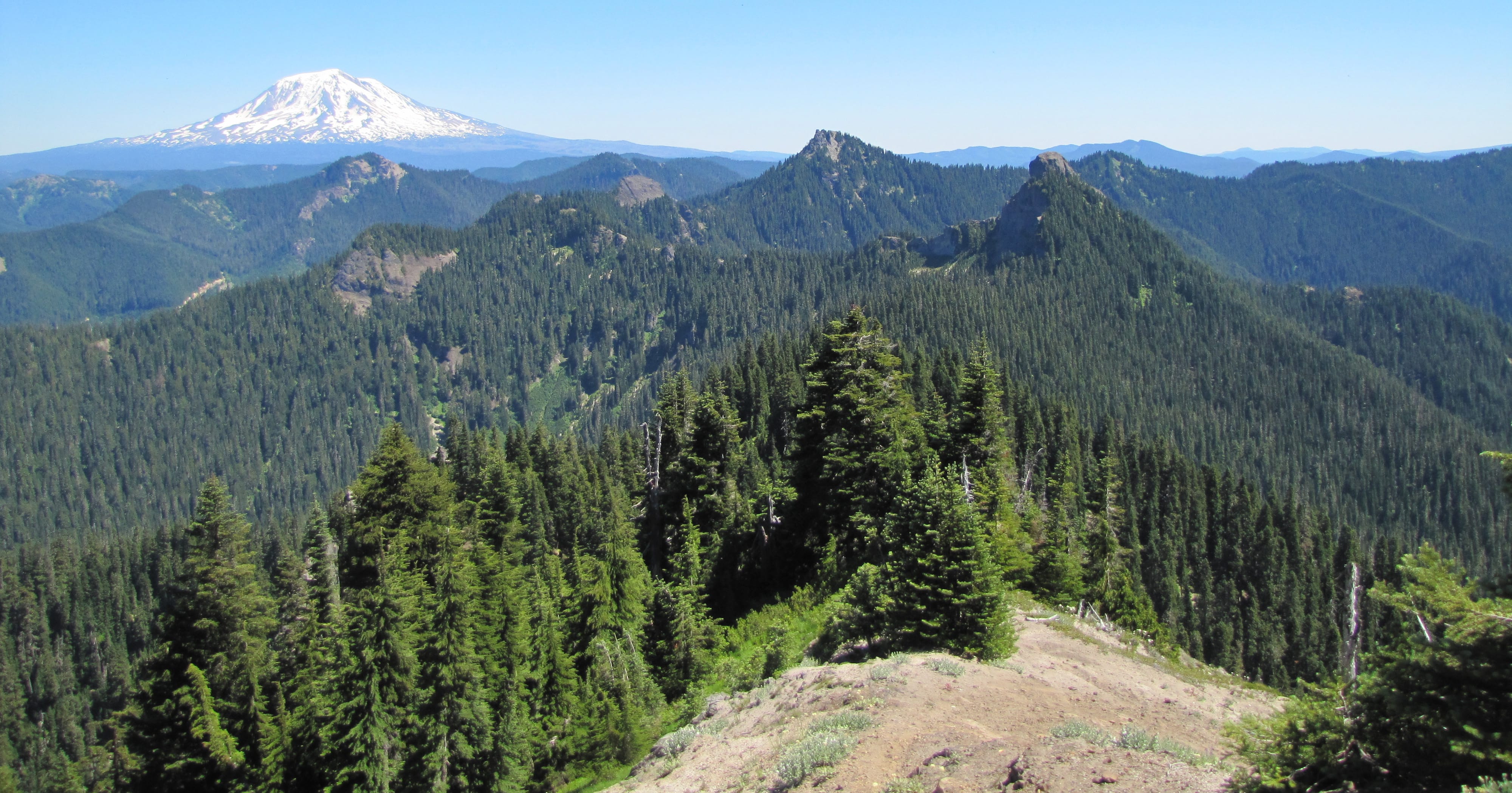
From the summit of Badger Peak, hikers get a view of the peaks and rocks of the Dark Divide roadless area, plus can see Mount Adams on the eastern horizon. (ALLEN THOMAS/The Columbian)
COUGAR — Some hikes are about the journey, the sights along the trail, and not necessarily the destination. Other hikes are all about the destination.
The 5.26-mile hike from Elk Pass to Badger Peak in the Gifford Pinchot National Forest is clearly about the destination.
Badger Peak, at nearly 5,700 feet elevation, is the westernmost of the big rocks and peaks in the Dark Divide roadless area.
There’s a 360-degree view from the summit, with Mounts Rainier, Adams, St. Helens and Hood visible, plus many of the lesser peaks like Kirk Rock, Shark Rock, Jumbo Peak and Sunrise Peak. There are often butterflies in abundance at the top of Badger Park (and generally plenty of black flies, too).
The footings of a fire lookout remain at the summit, plus there’s a 1937 Department of Agriculture marker denoting the the top.
To get to Badger Peak, start at the Boundary trail No. 1 trailhead on Gifford Pinchot road No. 25 at Elk Pass and follow Boundary trail for 4.51 miles east to the junction with Badger Ridge trail No. 257.
Head up Badger Ridge No. 257 for 0.3 mile to the junction with Badger Peak trail No. 257A, then up No. 257A for an additional 0.45 mile to the summit.
The key word here is up. The elevation gain is more than 600 feet in the final 0.75 mile.
The Forest Service calls it a “short but rugged side trail.’’
Visitors will want to go the very short distance beyond the junction of trails Nos. 1 and 257 to see Badger Lake, which is really more of a tarn than a lake. It does have a nice pumice beach and adjacent meadow.
The total elevation gain from Elk Pass to the summit of Badger Peak is 1,586 feet.
Boundary trail No. 1 is a national recreation trail, so designated in the late 1970s or early 1980s.
The trail is 53.7 miles overall, with the west end at Hummocks trail No. 229 west of Johnston Ridge Visitor Center north of Mount St. Helens and east end at Council Lake near Mount Adams.
Boundary trail is the only long east-west route across the Gifford Pinchot National Forest and it largely follows the ridge separating the North Fork of the Lewis and Cowlitz river drainages.
The trail was the boundary between the Rainier and Columbia national forests, hence the name. Now it marks the southern boundary of the Cowlitz Valley Ranger District.
“This was an important trail in the early history of the Forest Service as it was the principal route used by rangers on horseback patrols,’’ according to the Gifford Pinchot website. “The trail was well established by 1911.’’
However, there are some caveats about this trip.
• It’s a pretty typical walk through the woods. There are occasional glimpses of Mount St. Helens, and Mount St. Helens along the route, but not a lot.
• This stretch of the Boundary trail, and the feeder trails, are open to motorcycles. Hikers who have an issue with sharing a trail probably want to limit their trips to weekdays. Mountain bike riders also use the trails.
Boundary trail is hiker-only from Bear Meadows west, and open to motorcycles from Bear Meadows east.
Morning Briefing Newsletter
Get a rundown of the latest local and regional news every Mon-Fri morning.