BAKER CITY, Ore. — The Oregon Trail Interpretive Center will be the new home of a book of historic pioneer maps thanks to Sen. Ron Wyden.
Through a partnership between the Library of Congress and the office of the Oregon Democrat, the 170-year-old, seven-section topographical map of the Oregon Trail that is bound into a book, has been secured for display at the Interpretive Center on Flagstaff Hill about 5 miles east of Baker City.
Center Director Sarah LeCompte is excited to receive the map.
“It’s a great document to have,” she said. “It’s something that is really authentic and original that our visitors can see. Our visitors always love that — not a duplicate or a replica of the real thing, but the real thing.”
The Interpretive Center, which is operated by the BLM, will celebrate its 25th anniversary in May.
More than 2.2 million visitors have toured the center since it opened on May 23, 1992.
Wyden stated in a press release that as the son of a librarian, he is always gratified when a significant piece of history finds its proper home.
“That’s why I am so pleased to play a part in bringing this book of maps to Baker City where it can be appreciated for generations to come.”
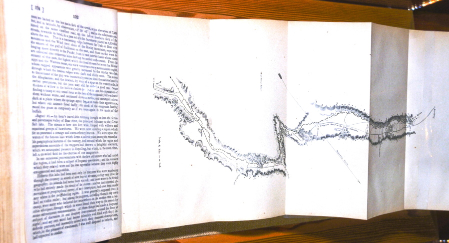
The map was developed by cartographer Charles Preuss, who accompanied frontiersman John C. Fr?mont and his wife Jesse Benton on an expedition along the route of the Oregon Trail from Missouri to Oregon in 1843. Fremont and his wife wrote a book about the expedition, “A Report of the Exploring Expedition to Oregon and California,” for the U.S. Congress that was published in 1845.
It included another version of the map also created by Preuss. The Interpretive Center has a copy of that report on display but does not have the map that was included with it. The map Wyden’s office has procured for the center is a larger and more detailed version of the one that was published with Fremont’s report.
Congress ordered the creation of this seven-section map in 1845 from the field notes and journal of Fremont along with the sketches and notes of Preuss. It was published in 1846.
LeCompte said the map will complement the center’s exhibits.
“(Fremont) was one of the first explorers to really document the route,” LeCompte said. “He followed the route that was later used by the Oregon Trail pioneers. Essentially those maps are the first accurate maps of the way out West.”
Wyden’s spokesman Hank Stern said the senator has interns who occasionally select books to fulfill requests from Oregon schools, libraries and eligible nonprofits. Almost all of these selections are recently published books. But occasionally the Library of Congress discards surplus books that are much older. The book of maps is one example of that.
“Wyden’s office recognized the historical value of the item and the office offered it to the Interpretive Center,” Stern said. “Senator Wyden strongly believes that history comes alive when people can see firsthand such unique documents as this book. And when it comes to the history of Oregon’s pioneers, the Oregon Trail Interpretive Center struck him as the perfect home for this 170-year-old treasure.”
LeCompte said the map will be on display at the Center in June.
The map’s debut at the Center will coincide with a temporary exhibit that depicts Fremont’s expedition along the Oregon Trail and includes items and artifacts from the journey and personal items that belonged to him. The exhibit originates from the Nevada State Museum in Carson City, Nevada, and the Deschutes Historical Museum of Bend.
“The timing is perfect,” LeCompte said.
The Interpretive Center is renting the exhibit for the summer of 2017.
LeCompte said the map is one of the first to show the route of the Oregon Trail.
The map includes temperature readings, elevations and weather patterns for each day of the journey, as well as extensive notes describing the terrain, flora and fauna, and the Native American tribes encountered on the 14-month journey.
“(The map) is a pretty important document,” LeCompte said. “(Fremont’s) writings and those maps were the first accurate information that was available for Americans making their way out West.”
According to Stern, the book of maps is quite rare. One copy that is not in great condition is for sale online at Arader Galleries for $6,800.
Fremont was an American military officer and an early explorer and mapmaker of the American West, who was one of the principal figures in opening up that region to settlement and was instrumental in the U.S. conquest and development of California. He was also a politician who ran unsuccessfully for the U.S. presidency in 1856 as the first candidate of the newly formed Republican Party.