ASTORIA, Ore. — Over the past 90 years, the coastline on the northern tip of Clatsop Spit has eroded by more than 1,100 feet. By 2010, wave action from the Pacific Ocean again threatened to breach the remaining dunes and reconnect Trestle Bay, a lagoon off the Columbia River, directly to the ocean.
While the U.S. Army Corps of Engineers is spending millions to reinforce the jetties around the mouth of the Columbia with large riprap boulders, the agency has turned to natural gravel beaches to protect the dunes, with promising results after three years of monitoring.
“A lot of our beaches are naturally cobbled beaches,” said Rod Moritz, a hydraulic engineer with the Army Corps. “It’s a very effective wave absorber.”
Between July and October 2013, contractors for the corps excavated 5 to 7 feet into the sand where the South Jetty meets the Clatsop Spit. They deposited more than 30,000 cubic yards of gravel and cobble stones in a cul-de-sac-shaped berm arcing 1,100 feet along the coastline, reported The Daily Astorian.
The berm, known as a dynamic revetment, emulates natural gravelly beaches. The larger rocks in the berm move onshore in the face of waves and high tides, as opposed to sand being pulled offshore.
Doing its job
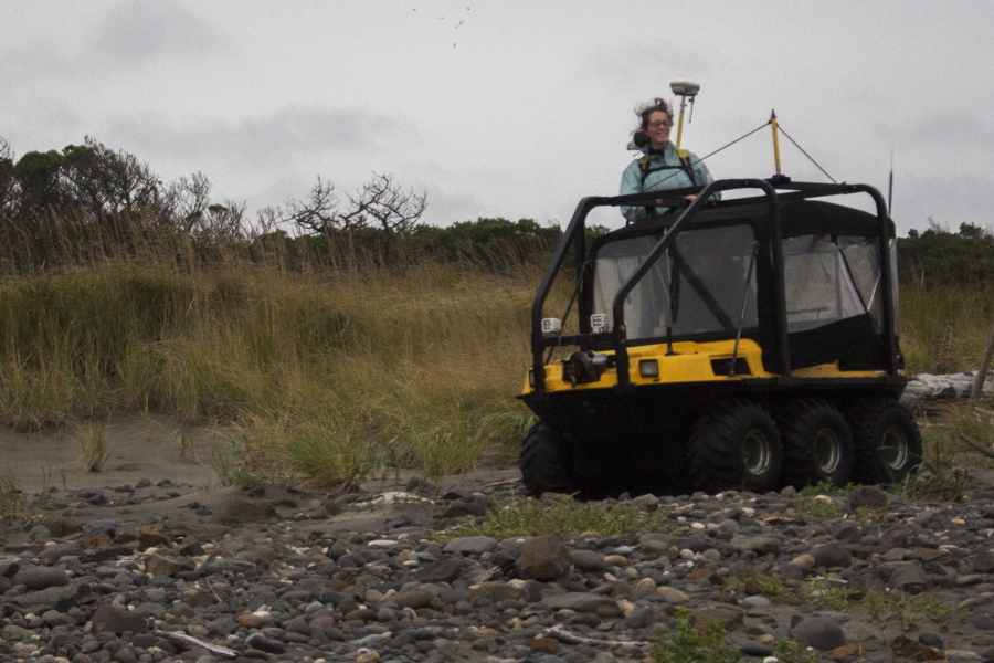
Since construction, a half-mile section of beach around the berm has been monitored regularly by coastal geomorphologist Jonathan Allan and field geologist Laura Gabel, both with the state Department of Geology and Mineral Industries.
The two take elevations and coordinates every meter using real-time kinematic GPS. Using a GPS unit in a backpack, triangulated with satellites and a GPS base station placed on a dune above the beach, they can track the topographical changes around the berm to within centimeters of accuracy. They were on site Wednesday, covering the entire berm on foot and in an all-terrain vehicle.
“It’s been here since 2013, doing its job,” Allan said.
The pair recently published a study monitoring the effectiveness of the berm. While the berm eroded more than 60 feet inland near the jetty, in a sacrificial area on the northern end, the structure has withstood multiple storm events.
Allan and Gabel were on the beach during heavy storms in December, when Allan said outgoing tides lowered the beach’s elevation by 2 feet, and large waves topped the dunes of Clatsop Spit.
Gabel said the berm held its ground, blunting the velocity of incoming waves. “If this structure hadn’t been there, there could have been a lot more erosion,” she said.
Moritz said the project has an expected life cycle of 30 to 50 years, but will need more material added every 10 to 15 years, depending on the severity of future storms.
An earlier test
In the mid-1990s, El Ni?o-induced storm erosion threatened Cape Lookout State Park and nearby condominiums.
Allan said he and Paul Komer, a professor of geology and geophysics at Oregon State University, proposed a dynamic revetment, a conceptual design known since the 1970s.
Local cobble was mined and placed along the beach at Cape Lookout State Park. “The structure there has served its purpose, protecting the state park,” Allan said.
While his and Gabel’s study said the berm at South Jetty has stood up to continued wave action, they cautioned that the area has experienced milder winters in the past few years, and that the berm remains to be tested by the worst storms. Monitoring at South Jetty continues through 2018.