BEND, Ore. — A shimmering layer of white had already blanketed the Cascades, so it was time to head east for a fall hiking adventure.
Each year, as winter slowly creeps in and our favorite higher-elevation hiking trails in Central Oregon are covered with snow, it seems we look to the opposite direction and rediscover the High Desert.
About 17 miles east of Bend, the Oregon Badlands Wilderness is nearly 30,000 acres of twisted junipers and interesting rock formations that make for an ideal hiking destination during the fall and winter.
Within the Badlands, the Dry River Canyon cuts through what historians say was once the bottom of a river that drained ancient Lake Millican. The Dry River’s course can be followed through the Badlands north to the Crooked River.
Dry River Canyon Trail
• Getting there: From Bend, go 17 miles east on U.S. Highway 20. Turn left immediately after Milepost 17. After crossing a cattle guard, turn right and drive through a gravel storage area. The road from here can be rough. After about a mile, you will see the trailhead.
• Difficulty: Easy, 2.3 miles one way.
• Cost: Free.
• Contact: Bureau of Land Management Prineville District, 541-416-6700.
Just off U.S. Highway 20, a 2.3-mile unmaintained trail follows the canyon bottom, providing an invigorating 4.6-mile round-trip hike in a half-day outing. The trail is closed each year from Feb. 1 to Aug. 31 to protect sensitive wildlife during breeding, which also makes fall a good time to visit Dry River Canyon.
Last week I made the short drive southeast of Bend to the Dry River Canyon Trailhead. It was a cool, clear morning, one of those days when dressing in layers was a necessity, as I knew I would warm up quickly during the hike.
The trail was incredibly sandy, quite deep in spots, but that will no doubt improve as rain and frost dampen the conditions this fall and pack down the dirt.
Hiking in the Badlands is markedly different from hiking in the Cascades. There are no jaw-dropping alpine vistas or gushing waterfalls that are impossible to miss in the mountains.
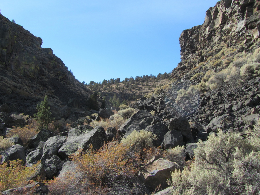
Truly enjoying a hike along the Dry River Canyon requires taking the time to study the eroded rock formations and the old, gnarled junipers.
Otherwise, it might feel as if you are simply walking through sand.
With this in mind, I continued along the flat, dusty trail as the canyon walls grew higher and higher. At one point, strips of red rock layers lined the high canyon. At another spot, the cliff walls were dotted with green.
According to the Bureau of Land Management, the drainage area of Dry River extends east to Hampton Butte and south to Pine Mountain and the east flank of Newberry caldera.
As deep as 300 feet in spots, the Dry River Canyon exposes layers of lava and cinders from the ancient volcanoes of Horse Ridge and Bear Creek Butte. (Horse Ridge Trailhead, located just across Highway 20 from the Dry River Canyon Trailhead, is a popular mountain biking location during the fall, winter and spring.)
As I walked through the dramatic canyon, I tried to picture the river gushing through the rock, slowly carving out the intriguing walls at which I stared.
The trail was lined in spots with large, rounded boulders, or grounded holes in bedrock formed by churning water, according to the BLM. These areas hold moisture after rain and provide water for wildlife.
Numerous birds chirped a cacophony of songs as I neared the end of the trail.
At 2.3 miles, the trail is blocked by massive lava boulders. This is where I turned around to head back the way I had come. But I could have continued.
According to the BLM, the trail resumes after about 50 yards of rock-hopping and continues for another three-quarters of a mile before emerging at Highway 20.
On the way back to the trailhead, I took in more of the rugged canyon walls and paused at several oddly shaped juniper trees.
By the time I made it back to the car, I was sweating and my shoes were filled with sand.
But my head was filled with geologic wonder of the ancient river that once surged through Central Oregon, leaving its mark in the Dry River Canyon.