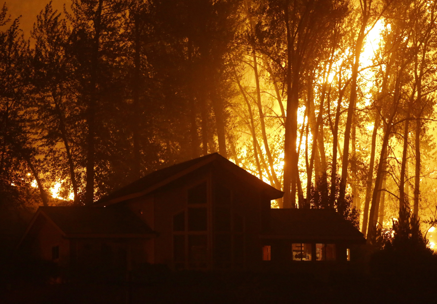
When a wildfire is rolling toward a house built with a cedar shake roof, surrounded by decorative juniper up to the windowsills, and the only access road is overgrown and narrow, firefighters will likely skip it.
“People think that we’re going to save their house,” said Paul Tester, Southwest Washington’s fire training coordinator at the state Department of Natural Resources. “We’re there to protect the firefighter and the public, that’s our first priority.
“We can rebuild a home, the trees will grow back. I can’t rebuild you.”
As more people build homes in spots where civilization mingles with the wild, firefighters may have to make those calls more often. In Southwest Washington’s now-regrown Yacolt Burn area, where one of the state’s largest wildfires tore through the region more than 100 years ago, people have built an estimated 800 homes, according to local assessors’ offices.
Reducing wildfire risk to homes
The Clark County Fire Marshal’s Office has these tips for reducing the risk of a wildfire reaching a home:
• Reduce the amount of fuel for a fire around the home by removing plants, particularly trees or shrubs, near the building.
• Remove tall, dry grasses, low branches and leaf accumulations that can provide a path for a fire to a home.
• Substitute more flammable plants with less-hazardous varieties.
• Remove leaves, needles and other combustible debris from roofs and gutters.
• Remove ladder fuels, which are combustible materials that allow a fire to move from lower to taller vegetation. This can be done by providing a separation between layers of vegetation, such as brush and trees.
• Move firewood and other combustible debris, such as wood scraps, grass clippings and leaf piles, at least 30 feet away and uphill from houses.
• For more information, contact your local fire district or the state Department of Natural Resources. Contact Megan McGowan-Fitzgerald with the DNR at 360-902-1317.
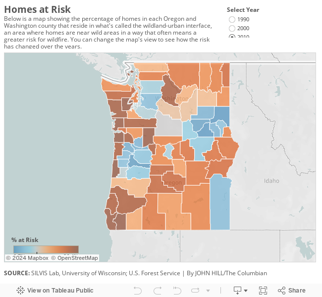
Researchers with the University of Wisconsin and U.S. Forest Service have found that about a third of all homes in the continental United States sit in what’s called the wildland-urban interface — a higher-risk fire area where homes and wild lands mix. Those homes housed an estimated 99 million people nationwide, the researchers said.
The wildland-urban interface area constitutes about 10 percent of the Lower 48. The number of homes in the risk area increased by about 8.5 million, or 24 percent, from 1990 to 2010. Since then, that number has likely increased, according to researchers and fire managers.
Wildfires destroyed almost 5,000 structures nationally in 2015, including more than 2,600 homes, according to the National Interagency Fire Center.
In Washington in 2010, 8.3 percent of the state was part of an interface zone, accounting for 36 percent of all homes. Last year, wildfires destroyed 343 houses in Washington, according to the National Interagency Fire Center. In Southwest Washington last year, 152 fires left 11 homes destroyed or damaged, and two of those homes were in Clark County, according to the DNR.
In Okanogan County, the site of the two largest fires in state history — the Okanogan Complex of 2015 and the Carlton Complex of 2014 — the number of homes in the interface grew by 34 percent from 1990 to 2010. Seventy-one percent of homes in Okanogan County were in the interface area in 2010, the researchers found. The two fires killed three firefighters and damaged or destroyed about 470 homes.
Susan Stewart, a staff scientist at the University of Wisconsin who studies the wildland-urban interface, said the analysis isn’t without caveats.
It uses satellite imagery to determine building and vegetation density, but it’s not purely a measure of fire risk. On its own, the map doesn’t take into account the environment and climate of each region. Also, the analysis was done based on 10-year U.S. Census data, and a lot can change between decades when it comes to building and plant growth.
But understanding the wildland-urban interface can help researchers know where fire risk is greatest, she said, because humans cause 80 to 90 percent of America’s wildfires.
“I think of Smokey (Bear), and Smokey’s got that match and Smokey tells you to be careful with your matches and be careful with your campfires,” Stewart said. “We have more houses out in these areas, people out in the wild lands, doing more things than camping.”
It’s people who live near the forest, she said: smokers; vehicles dragging chains on a road, causing sparks; homeowners burning something in the backyard.
“That’s really the paradox here,” she said. “People want to live close to nature. It’s just that where nature has a habit of burning, living close to nature is not always a simple thing.”
Con McClure was clearing some brush around his house Thursday afternoon. He lives with his wife in the Dole Valley area, not far from the Yacolt Burn State Forest and the old fire’s footprint.
“It’s all pretty much new growth here. You’ll see an old snag every once in a while,” he said. “What’s left of the burn.”
It would be challenging to get firefighters or water out there should a serious fire start, he said, but he’s done some broad planning for what he might do.
“I thought about it last year, when it was really dry. I gave it some heavy thought then,” he said.
There are more ways in and out of the area than there used to be, he said, which is encouraging, as is all the logging; there’s likely a lot less mass to burn near his house than there was in 1902.
“That was all heavy, heavy timber, but they’ve logged it hard. I can tell it just by the wind,” he said. “When I first moved here, to this location, there was no wind at all. Now I’m getting wind pretty much every day.”
Still, he said, it’s hard to miss the effects of growth.
There might have been one house on the road per mile years ago, he said, but not anymore. There are more people coming to the area for recreation, too, which means more reckless campfires, smoking and garbage.
“That’s the sad part of it all,” he said. “Beautiful area up here. They’re kind of destroying their own place.”
Tester, with the DNR, estimated that state firefighters spend 80 percent of their firefighting time working to keep flames away from homes.
The tactics and equipment for fighting a wildfire simply won’t help a burning house, Tester said. The propane tanks, paint cans or ammunition that might be on fire inside, along with the high emotions from homeowners, add to the danger.
“There’s times when there’s nothing we can do with a running fire,” he said. “We will pull everybody back to a staging area or a safety zone and stage there, because there’s nothing we can do. There’s literally nothing anybody can do.”
Local risks
About 19,000 homes in Clark County, or 11 percent of the total, were in the interface in 2010, the research shows. Even with the county’s growth, that amount is down 23 percent from 1990. Clark County’s own definition of the interface — which includes criteria for slope, vegetation and elevation — places 5,400 homes in the higher-fire-risk area.
What had for decades been the largest fire in state history, the roughly 350-square-mile Yacolt Burn, which ripped through multiple Southwest Washington counties in 1902, burned in the same area where local fire managers worry about the mix of wildfires and homes today.
“For all of us who live in the footprint of the Yacolt Burn, it’s something we do have to think about,” said Gordon Brooks, a battalion chief with Clark County Fire District 10, which includes many rural homes. “People have been living out in what we call the interface now forever. It’s just a way of life for rural fire responders in our area.”
In Skamania County, where most of the historic Yacolt fire burned, 94 percent of homes — about 5,000 of them — were in the interface in 2010. That was an increase of more than two-thirds over 20 years.
Southwest Washington has been lucky, Tester said. When the region’s thick, green woods dry out, the weather gets hot and the wind picks up, huge fires are possible in Western Washington forests.
There’s been a lot of progress, locally, toward making the area more fire-ready, the firefighters said. The local firefighting agencies complement each other; structure firefighters at local districts are trained to fight wildfires and they do rotations on state mobilizations to larger fires for experience. County officials make use of burn bans in the dry months.
Still, Brooks and Tester both said they’d like to see more communities actively consider planning around fire when zoning and building, and homeowners do more to make sure their homes can weather a passing fire. Small steps such as keeping gutters clean, lawns mowed or shrubs cut back from homes can go a long way, Tester said.
“People get complacent because of the rarity of that happening over here,” Tester said. “I think the last couple of summers, it could have been a possibility, because of the drought we’ve had.”
Better planning
Some of the strengths of the Forest Service’s interface map are its breadth and depth, Stewart said. The researchers released the first part of their work at the end of last fire season, adding information on changes over time this year, and it has garnered a lot of interest among foresters and scientists, Stewart said. The mapping, she said, could help researchers better understand the impact of invasive plants, yard watering, pets or other human activity on the surrounding land.
State foresters and fire managers are all interested in the urban interface, Stewart said, adding that a better understanding of where that volatile mix of homes and forest lies helps with planning.
Fighting wildfires cost more than $2.1 billion last year, according to the National Interagency Fire Center. In a one-week period in late August, the Forest Service said it spent an agency-record $243 million. That year, 52 percent of its budget went to firefighting, up from 16 percent in 1995.
“It has become more important as the fire problem has only gotten worse, in terms of more houses lost and more big fires,” Stewart said. “Policy leaders are looking for ways to convince the Congress, basically, that they need more support for managing wildfire.”