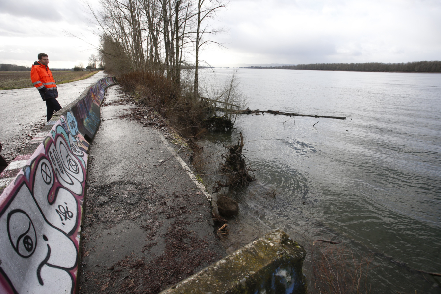
WSDOT spokesman Bart Treece visits the dead end of Lower River Road in early 2016 to examine ongoing erosion. This road segment is now permanently closed to public use; even if the area becomes a wildlife sanctuary, officials don’t want public bike or pedestrian paths going through it. The Columbian files Photo Gallery
Cyclists and birders who used to love rolling or strolling out to the dead end of Northwest Lower River Road have a new barrier blocking their way: private property. But if all goes according to plan, salmon and endangered species will thrive there someday.
The situation actually isn’t new. The Washington State Department of Transportation, longtime owner of the remote two-lane highway that snakes north past Frenchman’s Bar Park and the state Shillapoo Wildlife Area toward the Ridgefield National Wildlife Refuge, deeded the final 1.3 miles of the road — everything past the gate at milepost 10 — to Clark County in 2016.
The state didn’t want to maintain a crumbling road segment that’s precariously close to the Columbia River shoreline. (Where the pavement ends, chunks of asphalt are literally cracking off and falling into the river.) And Clark County, also not eager, agreed to return the segment to the adjacent private property owners, as long as standard access easements — chiefly for law enforcement and utility work — were retained.
There’s no longer any public access past milepost 10. For cyclists and pedestrians, that’s the new end of the road.
Like graffiti
Confusion about that last segment still lingers. That’s probably because of the incremental process of closing it off. For about a year, the road was blocked to cars but was still open to pedestrians and cyclists.
They came to relish their exclusive access. All they had to do was go around the locked gate to enjoy a quiet, car-free meander toward the southern boundary of the Ridgefield National Wildlife Refuge.
“I’ve been walking this area for years, and it’s been especially nice since that gate has been closed off for lack of vehicles,” said a man who emailed The Columbian in June. A bunch of crudely spray-painted “no trespassing” warnings at the gate look like graffiti, he said, so he’s used to bypassing the gate and proceeding.
In mid-June, though, he was confronted by angry inhabitants of the last dwelling on the road — and found the encounter pretty scary.
“They claimed it was private property and that I should not be there,” he wrote. “I tried to have some discussion with them, but they were very upset, so I opted to leave. I certainly was not trying to cause any trouble.”
This pedestrian said he called law enforcement both before and after the encounter. Vancouver police weren’t aware of any private property or trespassing issues. “They reiterated that I was OK to walk that road,” he said.
But he called Clark County Public Works and got a different answer: that road segment is closed to the public. The Columbian confirmed the same with Public Works spokesman Jeff Mize, who said: “This is now private property. Typically, cyclists and walkers should not venture onto private property without permission from the property owners.”
Peter Van Tilburg, vice president of Bike Clark County — who said he’s been similarly scolded by folks at the end of the road — agreed that the amateur spray job adds to the confusion. “It looks like an individual painted over the state signs,” he said.
Future fish and wildlife
“I think it would be great if sometime in the future they can extend the trail all the way” to the Ridgefield National Wildlife Refuge, Van Tilburg said. “It could be a wonderful bike and/or hiking route. I see a lot of birdwatchers there as well, especially during the migratory season.
That doesn’t appear likely. Adjacent property owners the New Columbia Garden Company (Fazio Brothers) and “RAA 2010 LCC” (Andersen Dairy) are pursuing a plan, in concert with state and federal environmental agencies, to let the dike underlying the road fail completely, and flood the land — as appears inevitable, anyway.
“We’re going to be flooded annually. We can’t invest in cropping anymore,” property owner Richard Fazio told a county public hearing in September 2016. “But it’s an excellent site for a fish bank. It’s the only thing left to do for our property there. We feel it’ll be a benefit to the Pacific Northwest and the recovery of salmon.”
Permitting that project has already taken years, he said, but once it’s underway, the Fazio family — which will be compensated via federal environmental credits it can sell — will maintain it for a decade. After that the land could be added to the Ridgefield National Wildlife Refuge to the north, Fazio said.
Fazio said the land would be replanted with “several hundred thousand” native trees, brushes and shrubs. “It was a forested area” and wetland for centuries before the dike and road got built, he said; that’s what it will become again.
Chris Lapp, manager of the Ridgefield National Wildlife Refuge, told the same hearing that he supports that plan — but opposes any public trail or bike path leading up to and into the Refuge from the south. “This area has basically always been a sanctuary. We want to maintain that,” he said.
Fazio agreed. “There’s been constant trespassing and garbage dumping,” he said. “If we allow access, that’s one of our big concerns.”
Morning Briefing Newsletter
Get a rundown of the latest local and regional news every Mon-Fri morning.