CHELATCHIE — The drizzle had resumed, yet it was hardly noticeable, on Siouxon trail No. 130 in the Gifford Pinchot National Forest.
When the clouds hang low in the Siouxon Creek canyon, the zillions of fir and hemlock needles constantly extract moisture, thus it’s always dripping. When it rains, it simply drips a little more.
Siouxon trail No. 130 is one of three classic drippy-day hikes in the southern end of the 1.3-million-acre national forest.
Along with Falls Creek Falls trail No. 152 and Lewis River No. 31, Siouxon provides a quality outing on cloudy — or even rainy — day.
And there has been no shortage of rainy days in 2017.
There are no panoramic views on these three trails to miss due to clouds and fog. When the horizon is hidden, stay in the river bottoms.
These three trails feature a hundred hues of green. There are firs and ferns. Moss is everywhere and all sizes and styles of waterfalls are abundant.
So until the sunshine comes to stay, consider this trio:
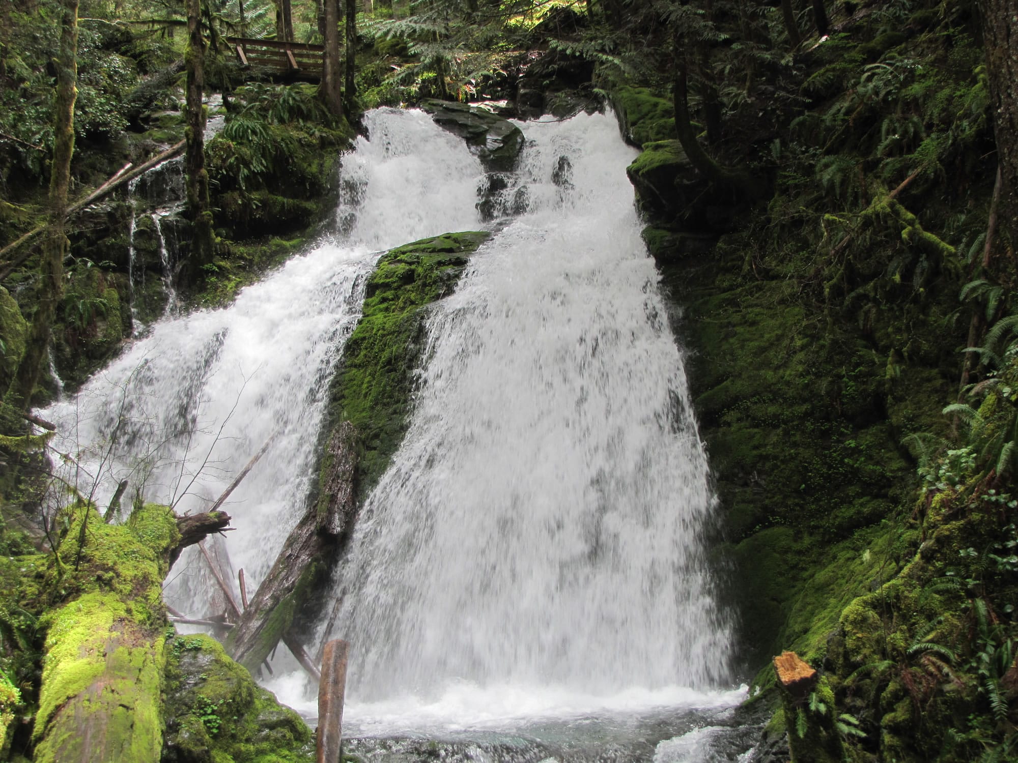
Siouxon No. 130 — The 10-mile round trip to Chinook Creek Falls follows Siouxon Creek nearly its entire way. It also passes over Horseshoe Creek Falls and there is a side trail to a viewpoint at the base of Horseshoe Creek Falls.
While there are lots of little climbs and dips, the route is relatively flat.
Siouxon Creek starts at Timbered Peak in Skamania County and flows 20 miles west to Yale Reservoir on the North Fork of the Lewis River.
The clarity of the creek is amazing, due in no small amount to the lack of roads and logging in the upper watershed.
The U.S. Forest Service, not an agency given to hype, described Siouxon Creek this way in its 1990 land-use plan: “Its subtle beauty below the forest canopy and a wide variety of water features from pools and riffles to spectacular waterfalls make it one of the most scenic rivers in the state of Washington.’’
At a minimum, hikers should plan to go the 1.7 miles (one way) to Horseshoe Creek Falls. The next highlight is Siouxon Falls at 2.35 miles. A bench at Siouxon Falls provides an ideal spot for a break.
Be advised, there’s a bit of a gnarly crossing of a tributary creek at mile 4.88, just before the bridge across Siouxon Creek on trail No. 130A, which leads another quarter-mile to must-see Chinook Creek Falls.
Scramble up the tributary stream to find a better crossing point than on the slick bed rock where the creek flows across trail No. 130. A trekking pole or walking staff is useful here.
Lower Falls Creek trail No. 152A — This is a relatively easy 1.54 miles with just 700 feet of elevation gain in the Wind River valley. The trail ends at a viewpoint of Falls Creek Falls, a triple-tier, 250-foot falls.
Falls Creek originates in Indian Heaven Wilderness and rushes to the Wind River. It makes this big drop where it squeezes between Middle Butte and South Butte.
The waterfall “is so outstanding one must wonder how it was given such a generic name,’’ according to Greg Plumb, a geographer who rates more than 600 falls in his book A Waterfall Lover’s Guide to the Pacific Northwest.
He rates Multnomah Falls a 93. He gives Falls Creek Falls at score of 99.
“Be prepared for all to stop in their tracks when they first see Falls Creek Falls,’’ writes author Joan Burton in her book Best Hikes with Children Western Washington & the Cascades. “Falls Creek is such a poor name for it….Magnificent Falls would be more like it.’’
Lewis River trail No. 31 — Four excellent waterfalls can be found in a 3.5-mile stretch of Lewis River trail No. 31 between Lower Falls campground and the end of the trail at Quartz Creek.
Lower Falls, Middle Falls, Upper Falls and Taitnapum Falls each only have a drop of 30 to 35 feet, but what makes them so special is the huge volume of water.
The North Fork of the Lewis River is a big stream. It originates high on the west flank of Mount Adams and drains a big area. That much water cascading over even a relatively short falls is impressive.
It takes about 90 minutes of hiking time (one way) to complete the trip.
Some hikers will turn around at Taitnapum Falls. The short distance between the falls and the trail’s end at Quartz Creek lacks any special attractions.
A couple of caveats come with this hike recommendation:
• Lewis River road No. 90 has a slide at mile post 28, which is near the Crab Creek bridge and short of Lower Falls campground. The Forest Service recommends not traveling the road until repairs are made, hopefully later this month. For updates, call 509-395-3402.
• Lewis River trail No. 31 has a permanent detour between Lower and Middle falls due to a landslide. The detour routes through Middle Falls trailhead parking area then back down to trail No. 31 on the east side.
TRIP TIPS
Siouxon Creek
DRIVING INSTRUCTIONS: Follow state Highway 503 to Chelatchie. At the store, turn right on Healy Road and go 2.2 miles to a four-way intersection. Keep straight on Gifford Pinchot road No. 54 for 6.8 miles to the junction with road No. 57. Road. 54 is blocked at this point. Go up road No. 57 for 1.2 miles to road No. 5701. Turn left and follow No. 5701 for 3.7 miles to the end of the road.
SEASON: Mid-March through November.
ELEVATIONS: At the trailhead, 1,430 feet. At the bridge across Siouxon Creek, 1,584 feet.
FEES: None
Falls Creek Falls
DRIVING INSTRUCTIONS: From Carson, go north 14.3 miles to the junction with Gifford Pinchot road No. 3062. Turn right and follow No. 3062 for about 2 miles. Take road No. 057 to the trailhead parking lot.
SEASON: April through November.
ELEVATIONS: The trailhead is at 1,260 feet and the falls viewpoint at 1,960 feet.
FEES: None
Upper North Lewis
DRIVING INSTRUCTIONS: From Cougar in southern Cowlitz County, go east on Highway 503 spur, which becomes Gifford Pinchot road No. 90. Go to the upper end of Swift Reservoir. At the junction with road No. 25, stay right on road No. 90, crossing Eagle Cliff Bridge and continuing 15 miles to the trailhead in Lower Falls campground.
SEASON: April through November
ELEVATIONS: About 1,500 to 1,700 feet
FEES: Day-use fees, a Northwest Forest Pass or national forest passes are required at Lower Falls.