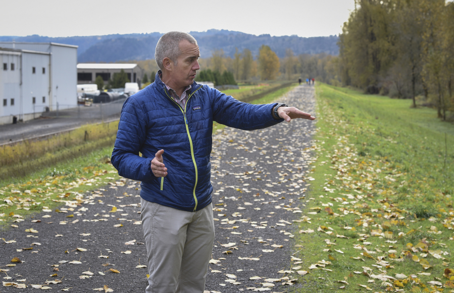
Standing in the lobby at the headquarters of the Port of Camas-Washougal, David Ripp pointed to a map of about 1,500 acres of land near the Columbia River that the port uses to support jobs and industry. He said what keeps this land dry and suitable for economic activity is a levee, 5 miles of rock, dirt and sand that keep the river from flooding.
“The reason for this levee is all this property would flood,” he said. “This would all be underwater.”
In Clark County, there are nearly 46 miles of levees, embankments along rivers that protect 16,170 acres of urban, rural and agricultural land. Some of them are periodically inspected by the U.S. Army Corps of Engineers to ensure that pumps are working and that the structure isn’t being unsettled by tree roots and animal burrows, among other issues.
Ripp said the Corps has taken a different approach to how it inspects levees since the August 2005 flooding of New Orleans by Hurricane Katrina. A federal judge ruled in 2009 that the Corps neglected the levees that broke and led to the flooding. Congress later directed the Corps to inventory and inspect federally overseen levees.
According to Corps spokesman Karim Delgado, levees are categorized as “urban” if they protect 20 or more buildings. There are three levees in Clark County, including the one owned by the Port of Camas-Washougal, that meet this designation.
Corps inspectors have found enough deficiencies in them to deem them “minimally acceptable.”
However, Ripp and representatives from other local governments said that the designation isn’t as bad as it sounds and that the levees are safe and being maintained. A database of levees kept by the Corps shows that of the 13,650 levees in Washington, 11 have fully “acceptable” ratings.
Although the area hasn’t experienced a recent major storm or disaster, like the storms that ravaged Puerto Rico and the South, this levee infrastructure could become more important as multiple forecasts predict wetter winters for the Pacific Northwest.
Port-owned levee
On a weekday morning, people rode bikes or jogged along a trail on top of the port’s levee. As he walked along the trail, Ripp explained that the levee was constructed by the Corps in 1965 and was built high enough to withstand the great flood of 1894, which saw the waters of the Columbia River reach 34 feet.
Ripp said the levee was most recently certified by the Federal Emergency Management Agency in 2012. With the levee certified, Ripp said the property behind it doesn’t need flood insurance. Getting that certification requires an inspection from the Corps, and Ripp said inspectors have been more scrutinizing than in the past.
“All of a sudden, everything is bad after Katrina,” he said.
The levee had its last periodic inspection in 2012, according to a database kept by the Corps. A summary of the inspection report identifies several items rated as “unsatisfactory,” including:
• Trees within a 15-foot buffer zone surrounding the levee (their roots can disrupt the carefully packed dirt and sand).
• Severe animal burrows.
• Several nonpermitted encroachments (e.g. utilities, buildings, guardrails).
• A lack of video inspection at a freshwater intake pipe and ambiguity over who’s responsible for maintenance of a portion of the levee downstream.
Inspectors also noted less serious concerns, including some bank erosion near the levee, ruts formed by pedestrian and vehicle activity, vegetation growth in the 15-foot buffer, as well as issues with the drainage structures and the pump station.
As Ripp continued to walk along the trail, he pointed to small mounds of dirt, evidence of burrowing moles.
“We have moles; that might be an issue,” he said. “But that’s not major.”
He also pointed to the 15-foot buffer between the toe of the levee (where its slope meets the ground) and the wooded edge of Steigerwald Lake National Wildlife Refuge, where the port knocked down trees as required by inspectors.
“They give that as a warning to us, saying, ‘don’t let any of that get any worse,’ ” Ripp said.
The port regularly puts $50,000 in its capital budget for levee maintenance, said Jeramy Wilcox, the port’s facilities manager.
“It’s just one of those things,” he said. “If we saw something, we’d do repairs.”
Clark-Cowlitz levee
Cowlitz County Diking Improvement District No. 2 is responsible for maintaining a 13-mile urban levee at the confluence of the Lewis River and the Columbia River that protects 7,772 acres of land that encompasses parts of Clark County as well as 555 acres of Woodland.
A summary of the 2012 inspection report identified the following “unacceptable” items:
• Trees with trunks greater than 2-inches in diameter were within the levee’s 15-foot buffer zone.
• There were several depressions deeper than 12 inches on the crest and side slopes of the levee.
• The condition of pipes and culverts wasn’t properly monitored.
• Chunks of rock used to armor the levee were obscured by “dense brush, trees, blackberries, and grasses, preventing inspection.”
• The drainage system for the levee’s toe on the Columbia River segment could not be found in the field, and there were no maintenance records to ensure it is functioning.
• Utilities had encroached under or through the floodwall.
• A closure structure blocked stop logs, which are used to adjust the flow rate of water, and were prevented from closing an opening on the flood wall completely.
• Joints had deteriorated and were no longer watertight.
• Pump stations weren’t monitored.
The inspection also found less serious issues, such as plant growth that inhibited observations of the levee, animal burrowing, minor erosion and some other minor issues with the pump stations.
The levee is currently rated as “minimally acceptable” by the Corps.
Susan Eugenis, assistant Cowlitz County engineer, said it may sound really bad, but that levee is safe and being maintained.
“If you see ‘minimally acceptable,’ that should not cause you any great worries,” she said. “It means you are working in the Corps’ parameters.”
During the flooding event of 1996, water levels rose high against the levee, and while there was some seepage, the structure prevented flooding, said Eugenis. The levee is owned and operated by a special diking district, and Eugenis added, “Honestly, I work with six districts, and I don’t know a single district that gets an acceptable rating.”
Fruit Valley levee
The city of Vancouver is responsible for a half-mile levee in the Fruit Valley neighborhood that protects 61 acres from floods. According to city maps, the levee is meant to protect against a 1 percent annual chance of a 100-year flood from Vancouver Lake.
The levee was last inspected in 2012, according to a Corps database. Like others in Clark County, it was rated “minimally acceptable.” An inspection report for the levee was not available on the Corps’ website.
Corps spokesman Delgado said the rating was based on the excessive vegetation that hindered the inspection.
“That may not necessarily mean that those areas wouldn’t perform as intended,” he said. “It’s just that we don’t know because of the excessive growth.”
In an email, Jon Wagner, Vancouver senior city planner, wrote that prior to the levee being deemed “minimally acceptable,” the latest FEMA maps “did not show any concern in the levee.” He wrote that he was unsure why it was given that designation. He further wrote that he was not aware of the city doing any work on the levee and it is in an acceptable condition.