Fire crews took advantage of cooler, wetter weather Saturday to strengthen defenses against fires burning on both sides of the Columbia River Gorge in advance of less favorable weather starting today.
“Weather is due to change, becoming drier and warmer today and Monday and more active fire behavior is expected as a result,” fire managers said in a statement this morning. “The changing weather conditions will begin to test the hard work firefighters have put in during the break from dry, hot, windy conditions.”
A weather system brought light rain to much of the area Saturday evening, but skies are expected to clear today, with highs near 80 today and 90 Monday, with east winds developing later tonight and Monday through the Columbia River Gorge. The winds are expected to be 6-10 mph, however, much less than early last week.
Archer Mountain Fire
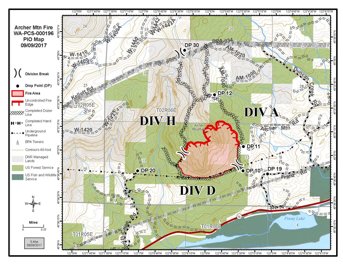
The containment of Archer Mountain Fire in Skamania County doubled as of this morning to 30 percent, according to the Washington Department of Natural Resources. Crews used strategic burns, expanding the total size of the fire to 253 acres, to further encircle the fire to prevent its spread.
Evacuation notices remained unchanged, with a Level 2 (be ready) evacuation notice on Smith-Cripe Road, Franz Road, Archer Mountain Road and private roads that connect to those roads, and Level 1 (be alert) evacuation notice on Mabee Mines Road and its tributaries.
The fire, which is believed to have been started by embers from the Eagle Creek Fire in Oregon, is burning in mature timber on rocky, steep terrain with a large amount of forest brush. It is burning on lands managed by the state Department of Natural Resources and the U.S. Forest Service.
Conditions remained favorable for firefighting this morning, with plans to secure south, east and west lines and to keep the fire within its current footprint. A DNR statement said the objective is to keep the fire east of Archer Creek, south of the BPA corridor, west of Duncan Creek and north of a pipeline that runs through the forest.
There are 110 personnel assigned to the fire.
Eagle Creek Fire
The estimated size of the Eagle Creek Fire on the Oregon side of the Columbia River Gorge was revised slightly downward this morning to 33,382 acres. Containment remained at 7 percent, according to a statement from the Oregon Fire Marshal.
Calm conditions Saturday allowed fire managers to conduct an aerial survey of the fire, and “their flight showed many many reasons to be positive about progress being made toward containing the fire,” the statement said.
Firefighters continued to close off the western end of the fire near Bridal Veil by strengthening line with burnouts. Much of the southwest side, difficult to reach because of steep, rugged conditions actually burned back on itself throughout the day.
The aerial reconnaissance detected very little smoke in a critical area north of the Bull Run Watershed, and the fire continued backing slowly down around the basins on the southeast fire perimeter and good preparation work was done above Lake Branch Road.
“All along the southeast and eastern flanks of the fire, scouting is underway to tie together a series of roads and trails to create a barrier to the fire’s eastern progression without putting firefighters in hazardous conditions encountered during a direct attack. The most active part of the fire yesterday was near Herman Creek; however, the fire has not yet crossed the creek,” the statement said.
Gifford Pinchot fires
The U.S. Forest service reported that Saturday’s lower temperatures and light rain kept fire activity low at the East Crater Fire near the Indian Heaven Wildnerness. The fire, which remains at 467-acres, has been burning since Sept. 3. Hikers are advised that the Indian Heaven Wilderness and a portion of the Pacific Crest Trail are closed due to the fire. Campsites around the Indian Heaven Wilderness are also closed.
Fire managers reported that crews made excellent progress securing the fire line and mopping up at the Bear Creek Fire near Carson. The fire, which remained at 36 acres, is a top priority for Mount Adams Ranger District personnel due to the values at risk and its importance as a water supply for the community of Carson.
Crews continued constructing line around the two-acre Siouxon Fire a quarter mile off the Siouxon Trail approximately one mile up from the 5701 Road trailhead. There were no trail closures as of this morning.