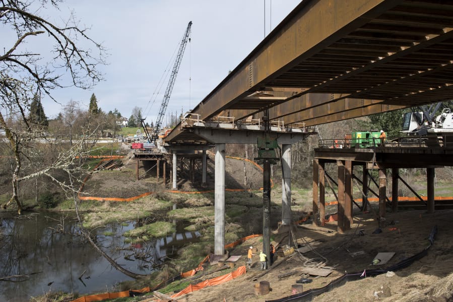
Construction crews reached a milestone last week when they placed long steel girders across Whipple Creek, nearing the goal of connecting Northeast 10th Avenue with 450-foot long bridge. Yet an amateur roadway historian says it’s just the latest modifications to a crossing site people have relied on since European settlers began moving to the area.
“This has come full circle,” said South Point resident Curt Cunningham, referencing the new bridge’s construction. “A hundred years ago, this was the thoroughfare. Now, Vancouver is starting to grow, and this road is needed again. Suburbia has finally met Whipple Creek.”
Right now, the area is a construction site; cranes, loaders and dump trucks move along a muddy roadway on either side of a long span of freshly installed rusty girders.
Clark County construction engineer Bart Arthur said the concrete bridge deck will likely be installed in early June and the project could be finished entirely in late October.
The project is being built on the west side of Interstate 5 on Northeast 10th Avenue between Northeast 154th Street and Northeast 164th Street.
The roughly $14.6 million bridge, a 450-foot-long, 48-foot-tall concrete and steel structure, should last for somewhere between 75 and 100 years.
County officials say that when it’s all finished, the bridge will bring many benefits to local businesses and residents. By spanning Whipple Creek, it will connect two dead-end stretches of Northeast 10th Avenue, and that in turn will create a secondary access route to the Clark County Event Center at the Fairgrounds and an alternate route for emergency responders. It’s also expected to enhance local land uses by bringing new water and sewer utility lines to the area, which is anticipated to be the site of much future growth and development.
“It’s the bottom end of the Discovery Corridor,” said project manager Troy Pierce.
Part of Pacific Highway
While the new span will give area drivers more options for moving around the county, Cunningham, an amateur historian of the Washington portion of the Pacific Highway, said the crossing over Whipple Creek was once a vital route for wagons traveling through Southwest Washington.
He says Northeast 10th Avenue has a long history as a vital road from Vancouver to communities up north. He said, after being alerted to the crossing by a friend online, he’s found evidence that the road was built as the main wagon road in and out of Vancouver in about the 1870s until about 1921.
Cunningham is confident that the road crossed Whipple Creek where the county is now building the new bridge. He believes the early road started with a very rudimentary structure across the water, followed by an untreated wooden bridge in 1905. According to his research, this section of what is now Northeast 10th Avenue became part of the Pacific Highway in 1915, but it was abandoned about six years later in favor of a route just a little to the east.
“This little section over Whipple Creek was on, for six years, a state highway roughly 1915 to 1922,” he said. “That state highway, for about six years, was a series of dirt roads stitched together.”
Officials in Clark County or the Washington Department of Transportation couldn’t verify Cunningham’s assertion. An 1894 county map on file with Clark County Public Works shows two different larger routes going around Northeast 10th Avenue, but Cunningham contends that those routes were added to the map later on.
“I’ve seen a lot of times where someone will write in the newer roads,” he said. “They didn’t make maps like we know them today because they were very expensive; if you had one, you just kept updating it.”
Cunningham said he’s studied the original route of the Pacific Highway between Vancouver and Olympia for about the last seven years. Because there’s little information out there about the earliest routes in and out of the region, his research occasionally sends him on scavenger hunts for old and practically forgotten maps tucked away in library archives — among other places. Still, he said he’s amassed a small collection of regional maps dating back as far as the 1850s.
Cunningham also explores the old highway routes hunting for fragmented highway sections of antique bits of asphalt tucked away in what are now fields, neighborhoods and, sometimes, residential driveways.
“Out here in Washington, we’re not as tuned in as they are out East. We don’t have signs delineating where the (original) roads are,” he said. “I’m trying to get more people interested in our roads.”