<img height="1" width="1" style="display:none" src="https://www.facebook.com/tr?id=192888919167017&amp;ev=PageView&amp;noscript=1">
Thursday,  April 25 , 2024

Linkedin Pinterest
News / Clark County News

St. Helens spews death, destruction

The Columbian's first story on the volcano's massive May 18, 1980, eruption

By The Columbian
Published: May 19, 1980, 12:00am
5 Photos
The eruption of May 18, 1980 sent volcanic ash, steam, water and debris to a height of 60,000 feet.
The eruption of May 18, 1980 sent volcanic ash, steam, water and debris to a height of 60,000 feet. The mountain lost 1,300 feet of altitude and about 2/3 of a cubic mile of material stream downward from the center of the plume and the formation and movement of pyroclastic flows down the left flank of the volcano. Photo Gallery

Originally published May 19, 1980.

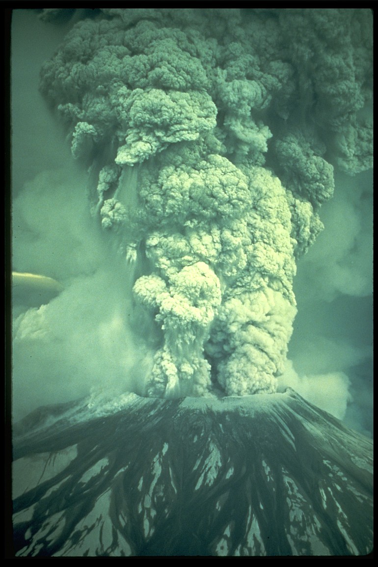
Mount St. Helens, the once-serene, cone-shaped peak that dominated the skyline northeast of Clark County and stood guard over the beautiful Spirit Lake recreation area, erupted with a force likened to an atom bomb Sunday, killing at least six and leaving 29 missing.

The mountain, about 45 miles from Vancouver’s back door, blew at 8:32 a.m. Sunday with an explosion that was heard 200 miles away in Canada but was unheard throughout the Vancouver-Portland area. The blast left the snow-capped mountain about 1,300 feet shorter than it was two days ago, spread death and destruction throughout the Toutle River valley north and west of the mountain and sent a gigantic ash cloud to the east.

By late morning today (May 19, 1980), that cloud had fanned out across several Northwest and Rocky Mountain states and was expected to continue all the way to New England.

Also by late morning, eight persons had been found. It was unknown whether they were among the 29 reported missing earlier. Five were picked up by rescue helicopters about eight miles from the volcano and three others were found four to five miles northwest of the mountain in the Fawn Lake area. No names were immediately available.

Mount St. Helens timeline

1800s: Mount St. Helens erupts explosively in 1800; intermittently from 1831 to 1857; then enters a 123-year quiet phase.

March 1980: Magnitude 4.1 earthquake signals reawakening. Eruption of ash and steam March 27, opening a 250-foot crater.?May 1980: Swelling on the north face creates an ominous bulge. Hundreds of earthquakes shake the mountain.

8:32 a.m. May 18, 1980: St. Helens' eruption, with its lateral blast, debris avalanche, mudflows and floods, claims 57 lives and obliterates virtually everything within an eight-mile radius. An ash column rises 15 miles and travels east at 60 mph, circling the globe in two weeks.

June-October 1980: Continuing eruptions destroy a lava dome inside the crater. A new dome forms.

September 1980: Weyerhaeuser Co. begins salvaging some of the 62,000 acres of timber and young plantations damaged by the blast.

Aug. 27, 1982: President Reagan signs a bill establishing the 110,000-acre Mount St. Helens National Volcanic Monument.

1987: Volcano summit reopened to recreational climbing.

1987: U.S. Army Corps of Engineers builds a dam to hold back sediment carried downstream by the North Fork of the Toutle.

1994: The reconstructed 52-mile-long Spirit Lake Memorial Highway opens to traffic, connecting Castle Rock to stunning viewpoints in the blast zone.

1997: The U.S. Forest Service opens the Johnston Ridge Observatory five miles from the crater.

Sept. 23, 2004: The mountain stirs with a flurry of earthquakes.

Oct. 2, 2004: Sustained tremors inside the mountain indicate movement of magma. The Forest Service evacuates visitors from Johnston Ridge Observatory.

Oct. 11, 2004: Lava emerges on the crater surface for the first time in 18 years.

Nov. 5, 2004: New dome reaches 26 million cubic yards.

Jan. 16, 2005: A 17-minute explosive eruption destroys instruments inside the crater.

March 8, 2005: The mountain sends ash and steam to an altitude of 36,000 feet, wowing spectators just before sunset.'

Early 2008: Dome-building slows to a halt and seismic activity drops.

July 13, 2008: Scientists declare that the 2004-2008 eruption has ended after building a new, 125-million-cubic-yard lava dome.

The pandora’s box of nature’s fury that followed the Sunday morning explosion:

• A series of mudflows raced down the two forks of the Toutle River, killing motorists, snapping a dozen or more highway bridges, sweeping away homes, cars and large logging equipment rigs. Many of the destroyed bridges were small spans across tributaries of the north and south forks of the Toutle, as well as over the Toutle forks.

• A searing explosion ripped a fan-shaped swath out of the forest on the northwest side of the peak, killing several persons by the shock of the blast or the heat. In some areas the trees were clipped neatly at about 20 feet above the ground; in other areas not even a stump remained. The swath was eight miles long and 15 miles wide.

• Ash, several feet deep in areas close to the peak, was pushed as far as 500 miles to the east where it “turned day into night.” One of the hardest hit is the Yakima area, but the impact is widespread. It has closed airports, halted all but the more serious emergency services, triggered school closures, and become a major health concern. By mid-morning today the ash cloud was as far east as Montana and Colorado.

Through it all, Clark and Skamania counties and the Longview-Kelso area escaped virtually unscathed as winds blew the ash away from those nearby populated areas south and west of the mountain.

As scientists reconstructed the chain of events, two major earthquakes struck the peak about one minute apart while most of the area’s residents were preparing Sunday breakfast. Those quakes are believed to have concentrated their force in the northside bulge of ice and rock that had been growing for several weeks at the rate of about five feet per day.

That blister of rock parted without warning. The Goat Rocks formation reportedly moved westward and the pent-up force of the peak burst forth with the searing explosion that was to be likened by many observers to the force of an atomic bomb.

Geologist Dan Miller said that studies of the peak indicated such an explosion had not taken place in the past 32,000 years.

In addition to snapping the trees, the heat burned the paint on logging gear miles from the summit. Large blocks of ice and rock rained down on the area that had just been striped of vegetation. Hot ash and cinders — several feet deep in a short time — came next, triggering forest fires. Hot gas flowed out of the hole in toxic levels.

Overhead, a giant gray cloud rose to 60,000 feet, creating its own weather, spawning a lightning storm that started even more fires. The total of fires from lightning strikes and hot cinders was more than 200, with some as large as 3,000 acres. But the ash then smothered most of the blazes.

The top of the once conical peak was sawed off at 8,400 feet, well below the old elevation of 9,677 feet above sea level. The crater, which once was 1,700 feet wide, now is described as being as much as one mile wide. The whole north side, blister and all, is gone, leaving a horseshoe or scoop-like chute that funneled load after load of white-hot ash down the north side and into Spirit Lake.

One scientist said the ash, believed composed of shards of natural glass mixed with gases, possibly as hot as about 1,500 degrees, was rolling down the north slope toward Spirit Lake for at least three hours Sunday.

Observers say Spirit Lake, site of a popular recreation area six miles north of St. Helens, is virtually gone. The once-majestic, picturesque lake is said to be a cauldron of logs, and boiling mud and water heated by repeated ash flows. There has been no word of feisty Harry R. Truman, 83, who had refused to leave his Mount St. Helens Lodge, but a geologist said today that there is only a “very slim” chance Truman survived. A helicopter pilot said there is no trace of the lodge, and the area is covered with 30 feet of ash.

The missing also include Reid Blackburn, 27, a photographer for The Columbian, and David Johnston, about 30, of Menlo Park, Calif. Johnston is a volcano expert for the U.S. Geological Survey. He and Blackburn were in camps about a mile apart about eight miles northwest of the mountain when it blew Sunday.

Flooding of the Toutle has pushed tens of thousands of logs, cleaned out of several Weyerhaeuser Co. sorting yards, downstream, wiping out steel and concrete bridges. A Weyerhaeuser official at corporate headquarters in Federal Way said “six to 12 Weyerhaeuser employees and families are missing. They may have gotten out to safety but we are still looking.”

Water was splashing over the closed Interstate 5 bridges at Castle Rock.

Among the survivors were two seriously burned loggers — they hiked eight miles to get help.

Among those killed were two California sightseers, a family of three trying to drive to safety ahead of flood waters, and a camper. In a volcano-related death, a pilot in Kittitas County, Wash, died when his plane hit power lines after the ash cloud turned the area to darkness.

Maj. Bill Hewes, mission coordinator the 304th Air Force Reserve Aerospace and Rescue Squadron from Portland, said he fears the death toll could go to 50. (The death toll eventually reached 57.)

One of Hewes’ pilots described one couple, found dead in their car 15 miles west of the peak near Camp Baker, as having been “fried” in the heat. “Trees and all the vegetation were laid out flat — singed, burned, steaming, sizzling — a terrible looking thing.”

Another pilot, Dwight E. Reber of Columbia Helicopters, risked his life three times during the afternoon in an effort to find Blackburn at the U.S. Geological Survey camp near Coldwater Creek. He said every tree is lying flat in a west-northwest direction, apparently knocked down by the blast. “There is a flow of white burning everything it touches as it moves down the west side of the mountain,” he said Sunday after a flight over the area. “Everywhere is hot and gray. There are places where the water of the north fork of the Toutle River appears to be boiling.”

Reber said, “It looks like the aftermath of an atomic explosion.” He said paint of logging gear was scorched.

Morning Briefing Newsletter envelope icon
Get a rundown of the latest local and regional news every Mon-Fri morning.

While rescue missions were being mounted on the mountain, and while officials worried about getting residents evacuated before a wall of mud washed down the streams, thousands of people waited near the confluence of the Toutle and Cowlitz rivers. When a 1½-mile long logjam reached that point, a number of people braved the logs to grab steelhead trout which were flopping on the surface, suffocating in the muddy water.

Interstate 5 has been closed several times as officials watch mud brush the bottoms of the twin spans. The freeway was opened again at mid-morning today, at least temporarily. Just downstream is the Burlington Northern railroad bridge, also closed. When I-5 is closed, the detour over winding roads through Raymond, Wash., is a nightmare. Roads also are closed in Eastern Washington because falling ash has cut visibility to virtually zero. Closures include Interstate 90, the states main east east-west route that links Seattle and Spokane via Ellensburg. The ash also has disabled countless vehicles by clogging air filters.

Of the 29 missing, four to 10 may have been in a “critical area” of extremely heavy ash fallout directly north of the peak. Some of those were believed to be in the area for recreation, some for logging-related work.

Geologist Joe Rosenbaum said today that, despite a number of observations of a second source of brownish ash late Sunday from northwest of the peak, there is no indication that there is a second volcano. He said the ash plumes are believed to have resulted when ash slid into water near Spirit Lake. Rosenbaum did say, however, that a fumarole (smoke hole) has been spotted near the southwest spillway of Spirit Lake.

Rosenbaum said one observer estimated the mountain crater now may be as deep as 5,000 feet.

Officials were meeting today to map a cleanup effort, according to Lora Murphy, of the state Department of Emergency Services. She said there has been no move to seek federal disaster funds, and none is planned until a full assessment can be made. She said state and federal experts are rushing analysis of the ash to see what threat is posed to livestock and agriculture.

Pacific Power & Light, which operates three hydroelectric dams south of the peak, said Swift Reservoir on the North Fork of the Lewis River rose five feet after mudflows on the Muddy River poured into the upper two miles of the 16-mile long lake. That left 25 feet of margin in the already lowered lake. The utility is spilling water in case additional flood storage is needed. The dams have not been damaged by quakes.

Loading...