Under a high canopy of old growth Douglas and silver fir, it’s easy for your senses to get trapped in the Trapper Creek Wilderness.
The Wind River Highway near the entry trailhead? A world away.
The hustle of downtown Vancouver just 60 miles distant? A universe away.
At just under 6,000 acres, the Trapper Creek Wilderness is one of the smallest federally designated wilderness areas in Washington. But it seems a world unto itself once you enter one of the last sizable areas of old growth forest in the southern part of the state.
In the southwest corner of the wilderness, the subalpine Soda Peaks Lake is a popular destination for a 10-mile round trip.
But the heart of Trapper Creek Wilderness is explored on a challenging 16-mile loop that follows the wilderness’ namesake creek before climbing to the top of 4,200-foot Observation Peak.
Trapper Creek is one of the state’s most accessible wilderness areas. The entry trailhead is less than a mile off the Wind River Highway about 15 miles north of Carson.
From the parking area and permit box, hikers follow the Trapper Creek Trail No. 192 for about a mile to the wilderness boundary. Here, at the junction with the Observation Peak Trail, is where the fun begins.
The forest canopy hundreds of feet above blocks the outside world. Underneath, the trail winds between old-growth trunks up to 10 feet wide. Oregon grape, salal and vanilla leaf give a forest floor a verdant tone.
While its easy to lose your senses, losing the trail is unlikely thanks to handmade signs posted by the Mazamas, a Portland-based mountaineering group.
The trail gently climbs for 2.5 miles until, at the junction with the Deer Cutoff Trail, it descends to Trapper Creek. In late summer the creek babbles softly, offering a calming din to a handful of primitive campsites along the banks.
This is a good spot to top off water bottles and take a rest. You’ll need it.
After another mile, the trail begins to climb steeply through a series of switchbacks, gaining 1,200 feet in 1.5 miles.
But there are treats along the way.
As the trail climbs out of the Trapper Creek valley, the forest occasionally offers a peek at the rocky pinnacles of Bare Mountain looming above to the west.
After a few more switchbacks, a rocky ledge offers an unobstructed view of Trapper Creek Falls, which pours 100 feet down the opposite side of the valley.
The trail levels off at roughly 3,300 feet, entering a forest of Sitka alders and silver fir. After crossing Trapper Creek near its headwaters, the loop heads toward Observation Peak with an eastbound turn off from the Trapper Creek Trail onto the Shortcut Trail.
After about a mile, the trail arrives at a four-way junction with the Observation Trail and the Observation Peak Trail. The route to the top is a 0.6-mile spur that climbs through dense forest until suddenly clearing at the peak.
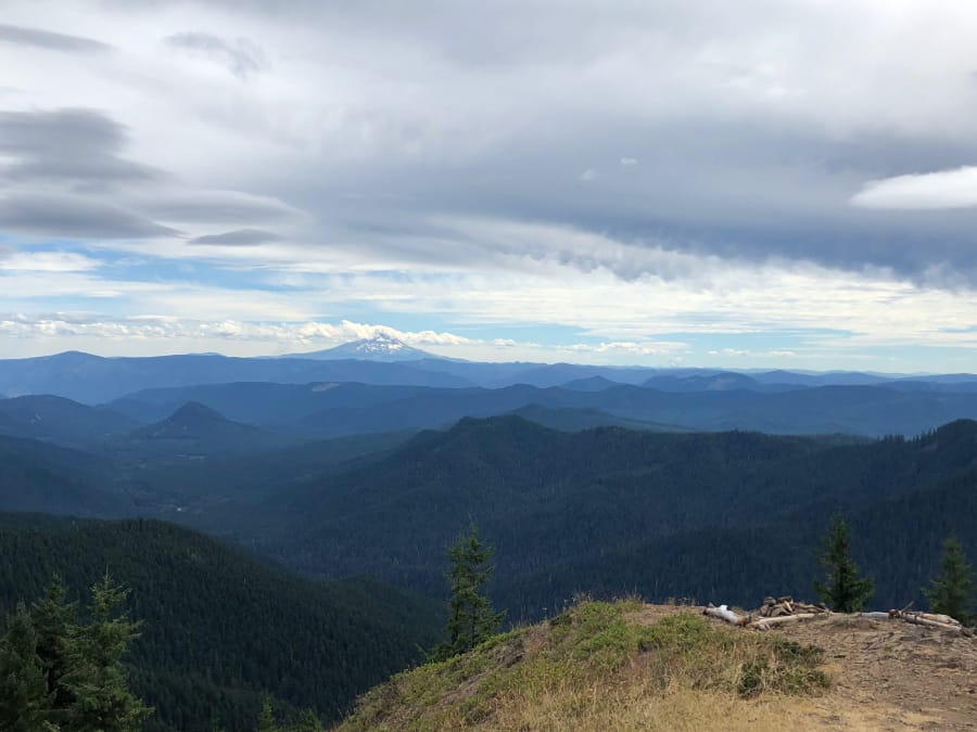
Here, at the site of a former fire lookout, the views are astounding. The entirety of the Trapper Creek Wilderness’ unbroken forest stretches out below, with the Wind River Valley and Mount Hood in the distance.
To the east, the Indian Heaven Wilderness lays at the feet of the imposing Mount Adams. To the north, the steep southeast wall of Mount St. Helens and the always majestic Mount Rainier crown the horizon.
After returning to the trail junction, it’s all downhill the rest of the way. The remaining six miles on the Observation Trail steadily descend along forested slopes until reaching the junction with the Trapper Creek Trail at the wilderness boundary.
The loop may take the better part of a day, but the wilderness escape from the outside world feels longer.
Getting there
From Vancouver, take Highway 14 east 48 miles to the Carson junction and turn north onto the Wind River Highway. After about 15 miles, turn onto Mineral Springs Road, cross the Wind River, then take the first right turn onto the gravel Little Soda Springs Road. Travel a half mile to reach the large gravel parking area, information kiosk and permit site at the Trapper Creek trailhead.