A local team of scientists is examining the burned area of the Big Hollow Fire in the Gifford Pinchot National Forest this week, checking for immediate dangers and what can be done to address them.
The team, which includes fire professionals, a biologist and an archaeologist, were drawn from a local professional pool due to limitations caused by COVID-19, said team leader J.D. Jones, a fisheries biologist.
Members started their work last week and plan to implement some safety treatments starting next week, Jones said.
The wildfire started Sept. 8. As of Oct. 1 it had burned 24,995 acres. Officials have not updated the acreage or containment level since the first of the month, but the fire is reportedly not growing. It is 40 percent contained, according to the U.S. Forest Service.
The fire is in Skamania County about 15 miles northwest of Carson and 7 miles southeast of Cougar. At its most intense point, the growing perimeter of the fire prompted evacuation notices for some north Clark County communities. An evacuation notice for Government Mineral Springs stayed in place the longest. Firefighters installed sprinklers around the cabins there as a precaution, but the fire never reached the area.
Gala Miller, U.S. Forest Service public affairs officer, said there were as many as 300 firefighters managing and battling the blaze on Sept. 19. The fire area received more than 2 inches of rain several days later, which significantly reduced its danger and spread. As of about a week ago, there were 16 personnel still working the fire, Miller said.
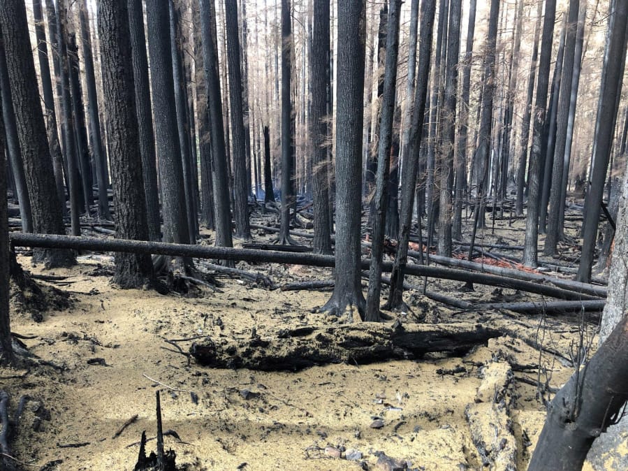
How much stand-clearing burning versus understory burning the fire caused is being determined, Miller said. Jones’ team and another team will provide more details in the coming months and weeks, she said.
“It has been observed that the fire left a mosaic pattern of burn intensity,” Miller said.
The cause of the fire remains unknown.
Closures inside the southwest portions of the burn area are in place to ensure public safety. The closure area includes developed campgrounds, dispersed camping, day use areas, wilderness areas and forest roads and trails.
“Due to ongoing hazards and rehabilitation work this current closure area is likely to stay in place until next spring or longer,” Miller said.
Areas on the south and west sides of the burn perimeter, as well Wind River Road/Forest Road 30 have been reopened as the threat from fire spreading has diminished.
However, hazards abound in certain portions of the forest. Jones reported that when he visited the popular Siouxon Creek Trailhead off Forest Road 5701 last week, he could hear trees falling every few minutes. The area was burned over, and the roots of the trees were also burned, meaning the roots can no longer hold the standing trees upright and in place. So, the trail, its parking lot and the road leading to it have been deemed unsafe.
Jones said officials want to limit the number of people who visit the forest for some time. He is working on determining the soil burn severity. When wildfires scorch intensely, soil becomes hydrophobic. This causes the soil to reject moisture and increases the risk of runoff and debris flows, he said.
His team is looking for areas where the debris flows are most likely to happen. It is also looking at areas left bare that may be the perfect environment for invasive species to take root and “explode,” and spots that require signage, or even more expensive gating, to prevent people from entering.
“We’re looking at where trees could fall over in recreation areas. Where these sites are and what can be effectively done in terms of treatment before snowfall,” Jones said.
The Big Hollow Creek drainage and Siouxon Creek Trailhead were both severely damaged, he said. Treatment plans for those spots and others in the forest will begin next week.
What the wildfire means for the future management of the forest is still being examined, officials said.