The Big Hollow Fire burning in the Gifford Pinchot National Forest grew in acreage Thursday, but precipitation forecast to stick around through today should help slow its spread.
The wildfire, which is 15 miles northwest of Carson and 7 miles southeast of Cougar, had burned a total of 24,309 acres, or about 38 square miles, as of Friday morning. It was 15 percent contained. The cause of the fire is still unknown, according to the U.S. Forest Service.
Meteorologist Bob Tobin said Thursday evening that the low-pressure system should offer between 24 to 30 hours of potential rain, with rainfall totaling between six-tenths of an inch to a half-inch.
However, the Forest Service noted that warm and dry conditions will return to the area Sunday through Tuesday. Incident Commander Bob Schindelar said Thursday, during the most recent community briefing, that this rain is a turning point in fighting the fire, but shifting weather means it could still be weeks until it’s out.
Washington Commissioner of Public Lands Hilary Franz visited the area near the wildfire Friday and told reporters that destructive fires such as the Big Hollow Fire and others in the state will happen with increasing frequency in future seasons. She said it is possible to manage and curtail the fires if investments are made toward the state’s firefighting capabilities.
The investments are needed so “we can rely on ourselves instead of hoping California and Oregon aren’t on fire and can offer help,” Franz said.
Fire operations
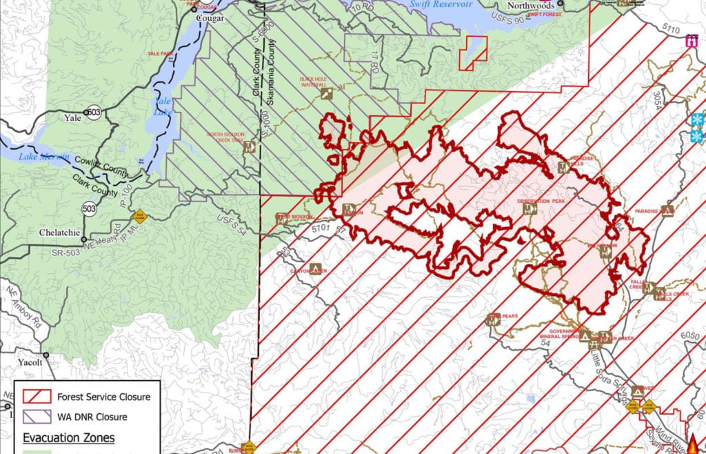
On Thursday, crews used heavy equipment to complete work on the S-1000 and S-6000 roads. Officials have said the various roads in the forest, which are being shaped up and cleared of burnable vegetation, are being used to confine the fire within that road system.
Preparation work along Road 3105 and Road 3107 have been completed, too. Sprinkler installation is done around the Government Mineral Springs cabins, and firefighters are periodically checking the area to see if the wildfire is creeping toward the buildings. As of Thursday evening, it hadn’t, according to Fire Operations Chief Aaron Rowe.
Also on Thursday, crews continued to monitor the fire’s growth at the Trapper Creek drainage and west of Wind River Highway.
For Friday, firefighters planned to patrol several roads and continue to clear others to limit the wildfire’s spread. They continued to monitor fire on the west ridge of Wind River Highway, as steep terrain makes taking direct action difficult.
The 31 road system is being prepped, and any fire that reaches Forest Road 30 “will be suppressed,” the Forest Service said. Firefighters will improve the condition of Forest Road 5407 to limit the fire’s spread south of Canyon Creek.
The cabins at Government Mineral Springs remain under a Level 3 “Go” evacuation order.
Areas north and west of the fire remain under a Level 1 “Get ready” evacuation order, including Yale, Cougar, Northwoods and portions of the towns of Amboy and Yacolt.
Closures in the southwest portion of the Gifford Pinchot National Forest remain in effect and include most developed campgrounds, dispersed camping, and most forest roads and trails. The Washington Department of Natural Resources has issued closures for the Siouxon Block and Merrill Lake Natural Conservation Area.