BEND, Ore. — Unseasonably warm weather in Central Oregon has extended hiking season into December.
It’s frustrating for skiers and snowboarders, who are eagerly waiting for area ski resorts to open, but it’s just fine for those who seek to trek the High Desert in ideal hiking conditions.
In Central Oregon, we are spoiled with trails that feature picturesque peaks, gushing waterfalls and pristine forests.
But come winter, most of those trails are — eventually — covered in snow. And for hikers seeking dry trails that can be accessed without the use of snowshoes or skis, areas east of Bend hold many treasures.
One such area is the Badlands, a 30,000-acre wilderness named for its harsh desert landscape. Because it is dotted with twisted old juniper trees and intricate rock formations in stark contrast to the spectacular mountain scenery found elsewhere in Central Oregon the Badlands is not on the top of every hiker’s list.
I think the true gift of the Badlands lies not in the scenery or the terrain, but in the opportunity it offers to lose yourself in the quiet serenity of the High Desert.
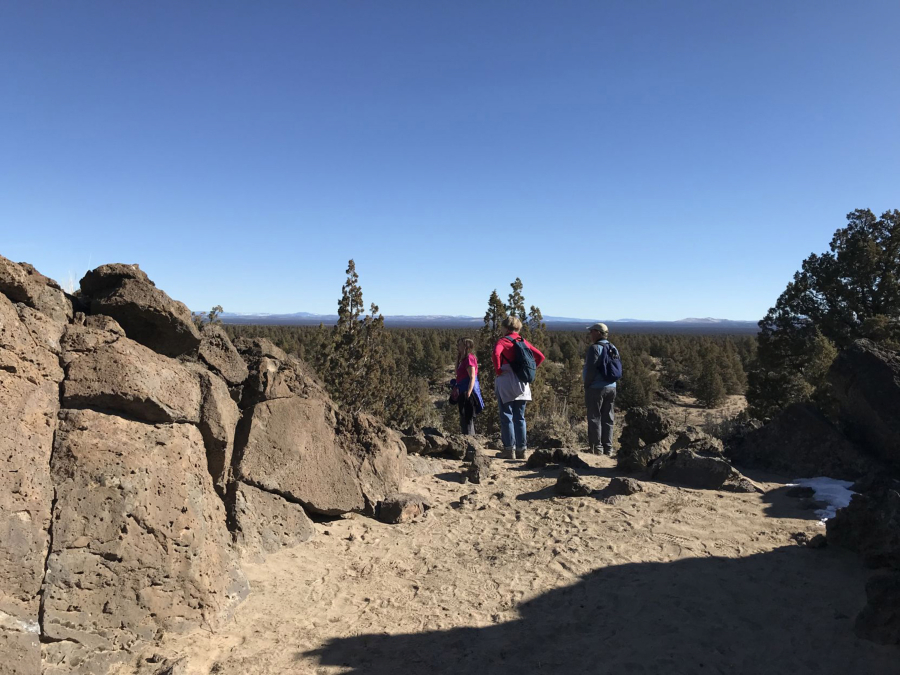
I recently drove about 16 miles east to the Flatiron Rock Trailhead, directly off U.S. Highway 20. This trail is one of the most popular in the Badlands because of its accessibility and because of its intriguing rock formations.
Most of the wilderness consists of the rugged Badlands volcano, which, according to the Bureau of Land Management, left behind thick basaltic lava flows.
Centuries of windblown volcanic ash and eroded lava formed the sand that covers the flat areas of the lava fields.
Walking the trail among junipers and sand, I found a nice rhythm along the flat trail on the relatively warm, clear day. I took the time to appreciate the detail of the gnarled juniper branches and the firm, wet dirt beneath my feet.
Some of the juniper trees in the Badlands are more than 1,000 years old, according to the Oregon Natural Desert Association.
The Oregon Badlands Wilderness Act was signed into law in 2009, permanently protecting the Badlands.
Ancient lava flows
The 3-mile trek to Flatiron Rock was a rambling stroll that seemed to go on and on. I finally reached my destination after about an hour of hiking.
Rising out of the sand in the middle of the Badlands, Flatiron Rock is an outcrop with rock walls that are lined by a few short trails. The rocks feature holes and gouges that were formed by ancient lava flows. Some of the rocks form jagged, strange arches at the top of the outcrop where sections of rock reach out to connect to one another.
On the clear day on top of Flatiron Rock, I could see northeast across the Badlands to the Ochoco Mountains and west to the snow-covered Cascade peaks.
A short loop around the top of Flatiron Rock allows hikers to view all the different rock formations up close. The Bureau of Land Management website describes Flatiron Rock as an oblong-shaped moat, or crack for a lunarlike hiking experience.
Past Flatiron Rock, the trail continues to the north boundary of Oregon Badlands Wilderness.
Another trail option in the Badlands is the Dry River Trail, a section of an old river channel. Starting from the Badlands Rock Trailhead, the Dry River Trail leads to the mouth of the Dry River channel, which features natural cave-like formations and faint red ocher petroglyphs from the natives who fished there thousands of years ago, according to the BLM.
The Dry River Trail is not to be confused with Dry River Canyon, which is also part of the Badlands and is closed each year from Feb. 1 to Aug. 31 to protect sensitive wildlife during breeding.