KENNEWICK — More snow blanketed the Northwest on Thursday, with fresh snow and slush that turned to ice overnight sending cars sliding in the Tri-Cities and leading to hours-long road closures on Interstates 84 and 90.
One person was killed in a rollover on Interstate 82 between Benton City and Prosser, and another crash between a car and a semi truck on Interstate 182 in Richland backed traffic up for miles into Pasco on Thursday morning.
As of 7:30 a.m., the Washington State Patrol had responded to 12 crashes in the greater Tri-Cities area, most of them on Interstates 82 and 182, according to Trooper Chris Thorson.
By 9 a.m., he reported on Twitter that traffic conditions were getting “worse by the minute. If you can stay off the highways today in Eastern Washington, then choose that option. If not, be very cautions and adjust your speed.”
Troopers had responded to 111 collisions by 5 p.m., Thorson told the Tri-City Herald.
“All of these are just people driving too fast for the roadway conditions,” he said. “They’re all speeding too fast for what they should be driving.”
Thorson noted that all of the highways are bad because there is “a lot of moisture and compact snow on the road,” and conditions don’t seem to be improving.
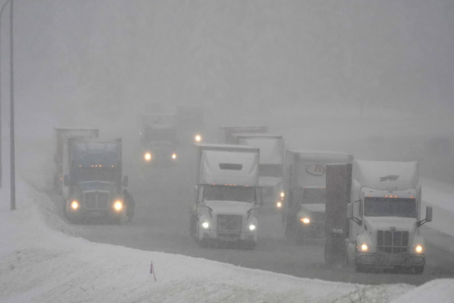
Just after noon, troopers were reporting blizzard conditions on I-82 south of the Tri-Cities to the Oregon border.
Thorson said his colleagues reported freezing rain and snow on the highway and that they can barely see because of high winds.
Farther up I-82, west of the Tri-Cities, troopers were dealing with multiple crashes all morning with the freeway reported to be “solid ice” between the Gibbon Road and Wine Country Road exits.
Just after 9:15 a.m., a motorist was reported trapped inside a pickup after it rolled into the median. Paramedics tried to save the man but he died 10 minutes later, said Thorson.
He was identified Thursday afternoon as Giver Jaurez, 23, of Toppenish.
He was not wearing a seatbelt, according to the WSP.
Meanwhile on I-182 in Richland, westbound traffic was backed up for four hours while crews worked to remove a semi truck’s trailer that had lost its rear axles.
Thorson said at 7:30 a.m., a car was traveling east when its driver lost control, went through the median and hit the semi in the westbound lanes. The crash was just west of the George Washington Way on ramp.
The car’s driver was reported to be unconscious, and someone, possibly an off-duty firefighter, pulled him from the car before it caught on fire. The man was conscious and talking by the time troopers arrived, and was taken to a Tri-Cities hospital with serious injuries, said Thorson.
He was identified later in the day as Michael Ver Mulm, 63, of Prosser.
The semi driver, who was from Spokane, was not injured.
First responders were heading out to another crash about 12:30 p.m., which was reported on St. Thomas Drive near Road 100 in Pasco.
Initial reports were that a person might be trapped in a crashed vehicle.
Police also were busy on Wednesday with crashes on icy roads in the Tri-Cities, including two crashes within hours on Bob Olson Parkway between West Hildebrand Boulevard and West 10th Avenue in Kennewick.
In the most serious crash, a Chevrolet Trailblazer rolled about 12:30 p.m.
A woman was thrown from the car and pinned beneath it. She had severe injuries and was expected to be flown to Harborview Medical Center in Seattle, according to police.
Snow closes I-84, I-90
About 70 miles of Interstate 90 closed in both directions from about North Bend to about Ellensburg 4:30 a.m. Thursday due to near zero visibility, according to the Washington state Department of Transportation.
Officials had hoped to reopen the interstate at 11 a.m., but still were working to clear the interstate then. The interstate did not reopen until shortly before 1 p.m., with chains required on most vehicles.
About 3:30 p.m. the interstate closed again from North Bend to Ellensburg after an SUV crashed into a tanker truck hauling sulfuric acid, according to the Department of Transportation.
No acid leaked but the Washington state Department of Ecology was called to separate the two vehicles. The front of the SUV was wedged under the side of the acid tank.
About 4:45 p.m. a detour was created around Cle Elum via Highway 270, but officials reported long backups on the road.
Interstate 84 also closed Thursday from about 6 to 10 a.m. from Pendleton to La Grande across Oregon due to blizzard conditions.
Because of limited parking for trucks in Baker City and La Grande, westbound trucks were stopped at Ontario, Ore.
Oregon Department of Transportation crews reported white-out conditions and high winds that were creating snow drifts in some areas of I-84.
Multiple trucks had spun out on the highway.
Travelers were advised that Highway 245 and Highway 204 in Oregon also were closed and could not be used as detours.
Highway 204, the Tollgate Highway, had 12 inches of new snow over three hours, the Department of Transportation said at 7:30 a.m. Thursday.
Tri-Cities closures
Pacific Northwest National Laboratory in Richland sent workers home shortly before noon on Thursday as the snow started up again in the Tri-Cities.
Franklin County also sent its workers home midday, although the courthouse remained open.
The Hanford nuclear reservation told many of the employees working on the site and in Richland to go home early at 3 p.m.
Those teleworking and with jobs essential to safety and security were told to complete a full day’s work. Swing and graveyard shifts were not canceled.
Many of the 11,000 workers employed for environmental cleanup of the Hanford site work 10 hour days Mondays through Thursdays and Thursday was a holiday day off for New Year’s.
Tri-Cities forecast
Even colder weather is yet to come for the Tri-Cities through the weekend courtesy of Arctic air, but temperatures could warm above freezing on Monday.
The warmer weather could turn precipitation to rain, or a mix of rain and snow, starting Sunday night in the Tri-Cities.
Thursday night the low was forecast at 16, dropping to just 9 degrees on Friday night.
New Year’s Day could be the coldest day yet to come before weather starts to warm some.
The National Weather Service forecasts a high of just 21, but with a variation of a few degrees possible, that high might not climb above the teens.
Temperatures will start to warm some after New Year’s Day, with a high of 29 forecast for Sunday and temperatures returning to about normal for late December and early January on Monday.
The high is forecast at 39 and the low at around 30.
Rain and snow are likely Monday from about 4 to 10 a.m., turning to rain later in the day.
Snow is also possible Tuesday, but rain is more likely to fall at elevations below 600 feet. Much of the Tri-Cities is at about 400 feet.
Travel forecast
Travelers returning to the Tri-Cities after the holiday weekend may face more bad road conditions.
Snow is expected on I-90 over the Cascade Mountains on Sunday, with 3 to 5 inches of new snow Sunday during the day and possibly heavy snow that night through at least Monday night, according to the National Weather Service.
The forecast calls for snow to continue to fall through at least Wednesday.
Travelers on I-84 through Eastern Oregon can expect snow from Sunday night through Wednesday.