If you made a list of the best natural attractions in and around Cannon Beach, you’d have to get pretty far down before mentioning the Ecola Creek Forest Reserve.
That’s no knock against the 1,040-acre reserve, a place of quiet beauty in the forests east of town, it’s just that when it comes to natural attractions on this stretch of the north Oregon coast, there happens to be a lot of competition.
Tourists are more likely to visit the famous Haystack Rock, the cliffside trails of Ecola State Park, the surfing paradise at Short Sand Beach or the oceanside Hug Point Falls. Those in search of forested hikes have other options as well, with the coastal forests of Tillamook Head and Oswald West State Park to choose from.
With so many other opportunities at hand, why visit Ecola Creek?
Truthfully, the small forest reserve isn’t for everyone. It lacks a certain “wow” factor that many hikers expect on the coast, and its tiny parking area ensures that, outside of nearby residents and those who walk to the trailhead from downtown Cannon beach, only few people can visit at one time. But for the seasoned Oregon coast traveler looking for something new, or anyone in search of a quieter excursion into nature, it makes a great add-on to your trip.
The Ecola Creek Forest Reserve protects part of the Ecola Creek watershed serving Cannon Beach, making it practical as well as scenic. The city purchased the land between 1999 and 2009, and allows the public to explore the hiking trails and access roads that run through it. Hikers will find evidence of the reserve’s more functional features, such as the water treatment facility less than a mile in, as well as natural wonders.
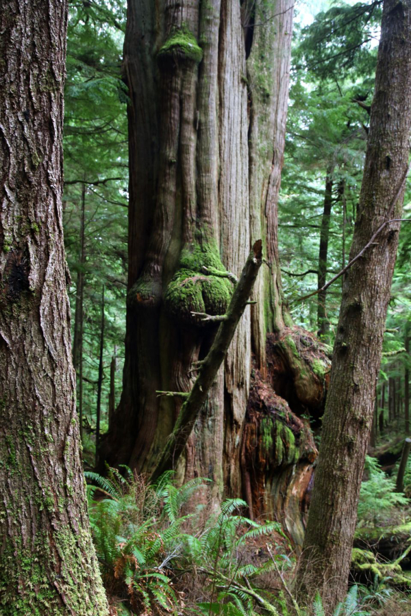
When city officials purchased the land in 1999, it included a small remnant of old-growth coastal rainforest that was spared from the saw blades that cut through most of the region. The old trees come about one mile into the hike, though you won’t have any trouble spotting them.
Towering western red cedars and huge Sitka spruce trees fill the forest, the ground in between blanketed in bushy green sword ferns. Enormous, rotting stumps are home to trees that are plenty big in their own right, illustrating the many generations that have thrived here. The branching forks of Ecola Creek thread through the forest reserve, their waters shallow and clear, habitat for rough-skinned newts that crawl along the banks and across muddy trails.
The whole reserve is filled with that unmistakable musk of Pacific Northwest forest: the scent of rotted wood and rain, of cedar and moss, decay and fresh life commingling.
A maze of trails runs through the area, but hikers would do well to stick to the main paths. Though mostly unsigned, those main paths are easy enough to follow. From the trailhead at the end of Elk Creek Road, access roads and dirt trails offer an out-and-back hike of two to four miles, with varying levels of difficulty.
The easiest excursion takes you one mile into the preserve, to the beginning of the old-growth forest, and back. Those who don’t mind some elevation gain can continue on up a few steep hills that run deeper into the forest for another half mile.
A signed pedestrian-only trail offers a side trip for the more adventurous hikers, adding an extra mile to your day. The narrow trail runs through dense clusters of sword ferns and many deep patches of mud, ending with a short, but necessary creek crossing. The shallow water is easy enough to walk through with bare feet, but depending on the season, it might not be the most comfortable experience.
In the winter, Ecola Creek offers easy access to a coastal rainforest in its element; in the summer, it can be a nice place to get out of the sun. The reserve might not be as awesome as some of its neighboring natural attractions – there are no views or waterfalls to speak of – but the big trees and old forest offer an opportunity for a different, quieter kind of awe.
ECOLA CREEK FOREST RESERVE HIKE
Difficulty: Easy to moderate
Distance: 2 to 4 miles
Amenities: None
As mentioned above, there are a few different ways to hike Ecola Creek, ranging from an easy walk to a more challenging adventure. These directions will go through it all, so feel free to stop and turn around whenever you want. It should also be noted that there are many more trails in the area that won’t be included here. Make sure you follow the directions, or else risk getting lost on the unsigned trails.
Find the Ecola Creek Trailhead at the end of Elk Creek Road, just east of U.S. 101 in Cannon Beach. After passing through a residential area, the road will end at a white gate, where there’s only room for about a half dozen cars to park. If there’s no room, turn around and try again another time. It is possible to walk to the trailhead from downtown Cannon Beach, using the sidewalk on E. Sunset Blvd to cross under the highway, then walking along the residential Elk Creek Road to the gate. From the Haystack Rock public parking lot, it’s about .7 miles each way.
Walk past the gate, where you’ll find a sign welcoming you to the reserve. The trail at the beginning follows a gravel access road through a young forest. Keep right at the fork after .7 miles and look for the water treatment facility on your left.
Just past the facility, a bridge crosses West Fork Ecola Creek and the trail dips down into the old-growth forest. Take your time in this section and appreciate the size and age of these trees. You’ll see a signed pedestrian-only trail on your left, but ignore it for now and continue through the forest.
After about a mile, the trail will reach the base of a steep hill. Feel free to turn around and enjoy an easy walk back the way you came, otherwise soldier on ahead uphill. Ignore the lone trail junction on the hill, which goes left and ends after only a tenth of a mile. After half a mile, the main trail dead-ends in the middle of the forest, offering a place to rest before heading back.
Back at the bottom of the hill, you can simply walk back the way you came for a three-mile round-trip hike. Those in search of more adventure, however, can next take the pedestrian-only trail you passed on the way in.
This trail runs one mile in all, looping back around to the first fork in the road on the way in. It runs along the dense forest floor, through sword ferns and thick patches of mud that make mobility a bit more difficult. Watch for rough-skinned newts underfoot and DO NOT touch them – the newts can secrete a dangerous neurotoxin from their skin.
The trail eventually spits you out at an unsigned junction after .7 miles. Go left and follow a grassy trail past a small pond. You’ll soon see the water treatment facility on your left, but before you can reach it, you’ll need to get across the creek. The shallow, gentle creek is easy enough to ford in bare feet or water shoes, though the water might be cold in the winter. Don’t force it if you feel uncomfortable – you can always turn around and go back the way you came.
On the other side of the creek, you’ll find another access road. Stay right onto the road, and you’ll soon be back on the path you walked in on. Continue straight to get back to the trailhead.