LOS ANGELES — It was a harrowing vision of the vulnerability of aging California dams — crews laboring feverishly to sandbag and drain the lower San Fernando Reservoir, as billions of gallons of Los Angeles drinking water lapped at the edge of a crumbling, earthquake-damaged embankment that threatened catastrophe on the neighborhoods below.
Although the 1971 San Fernando earthquake and the near failure of the Lower Van Norman Dam have given rise to construction improvements — the much newer Los Angeles Dam survived an equivalent shaking in the 1994 Northridge quake — the overwhelming majority of California dams are decades past their design life span.
And while earthquakes still loom as the greatest threat to California’s massive collection of dams, experts warn that these aging structures will be challenged further by a new and emerging hazard: “whiplashing shifts” in extreme weather due to climate change.
“The biggest issue facing dam safety in California is aging infrastructure and lack of money to fund repairs and retrofits of dams,” said Sharon K. Tapia, who leads the Division of Safety of Dams at the California Department of Water Resources. “Many older dams were built using construction methods considered outdated by today’s standards.”
Federal engineers have found that three major dams in Southern California — Whittier Narrows, Prado and Mojave River — are structurally unsafe and could collapse in a significant flood event and potentially inundate millions of people downstream.
Each has been reclassified as “high urgency structures” amid growing concerns that they were designed and built on 20th-century assumptions and hydrological records that did not anticipate the region being hit more frequently by storms that were previously regarded as once-in-a-lifetime events.
“Even if engineers had made risk assessments that were accurate at the time these structures were built, they aren’t accurate now, and won’t be anymore due to climate change,” said Daniel Swain, a UCLA climatologist.
These extreme weather events compound problems posed by earthquakes, which are inherently unpredictable and can cause safety problems that remain hidden or hard to identify.
Such was the case when the San Fernando, or Sylmar, quake struck before dawn 50 years ago this week and nearly collapsed the Lower Van Norman Dam in Granada Hills.
The 1,100-foot dam, which began construction in 1912, held 3.6 billion gallons of water on the morning of Feb. 9, 1971. Due to earthquake concerns identified five years earlier, the reservoir was ordered to be kept below full capacity, and on that morning the water level measured 36 feet below the lip of the dam.
The top 30 feet of the rolled earth dam crumbled and sank into the reservoir, leaving the water only 6 feet from the top with fresh chunks of earth falling off with each aftershock. Not since 1925, when a 6.8 magnitude quake destroyed the Sheffield Dam and sent 30 million gallons of water coursing through Santa Barbara, had California faced such a seismic-related crisis.
Authorities ordered the evacuation of 80,000 people living below the dam in an area bounded by the San Diego Freeway on the east, Victory Boulevard on the south, Balboa Boulevard on the west and Rinaldi Street on the north.
Engineers spent the next three days pumping water from the dam through a 24-inch hole cut in an aqueduct pipe.
Scientists later estimated that collapse of the dam would have killed as many as 123,400 people.
The brush with catastrophe prompted seismic re-evaluations and retrofits of dams throughout the state, most of them built for a 50-year life span. The average age of a California dam, state dam safety officials say, is 70.
Today, about 75% of the 1,250 dams regulated by the state Department of Safety of Dams are more than 50 years old. In addition, 250 are classified as “extremely high hazard,” indicating that their failure or misoperation is expected to result in loss of life and economic damage.
A scenario published by the U.S. Geological Survey warns that a rare mega-storm, or what experts call an Arkstorm, could last for weeks, causing structural and economic damage that would amount to $725 billion statewide.
Until only recently, it was thought that a flood of the magnitude similar to the one that hit California during the rainy season of 1861-62 and dropped 36 inches of rain on Los Angeles, could only occur every 1,000 to 10,000 years.
Recent studies, however, suggest that the chances of seeing another flood of that size over the next 40 years are about 50-50.
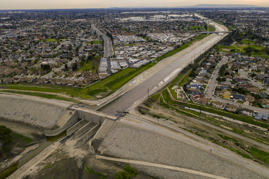
Now, the U.S. Army Corps of Engineers’ top priorities in Southern California include spending an estimated $600 million to upgrade the 62-year-old Whittier Narrows Dam, built in a natural gap in the hills about 11 miles east of downtown Los Angeles.
The earthen dam was placed in the agency’s highest risk category when it determined three potential failure modes threatened more than 1 million people downstream from Pico Rivera to Long Beach. They included the premature opening of the San Gabriel River Spillway gates, erosion resulting from water piping through the foundation of the dam and overtopping during an extreme flood event.
Federal engineers say that while the first would result in downstream flooding, the latter two could result in catastrophic failure of a structure built to rein in one of the steepest rivers in the U.S. From its boulder-strewn forks in the San Gabriel Mountains, the river plunges some 9,900 feet to Irwindale.
The modifications to prevent the dam from failing if overtopped include placing roller-compacted concrete on the crest and downstream slope of the embankment and improving the seepage control system with trench drains and other features.
The project is expected to be completed by 2026, officials said, with environmental monitoring extending through 2031.
In 2019, the Army Corps determined that a significant flood event could compromise the concrete slab of the spillway of the 80-year-old Prado Dam on the Santa Ana River, potentially flooding an estimated 1.4 million people in dozens of Orange County communities from Disneyland to Newport Beach.
Untamed, the Santa Ana River has been as fickle as it has been destructive.
It took what has been called the “storm of the century” in March of 1938 to spur action. Devastating rains lashed Southern California, leaving 119 people dead, 2,000 homeless and 68,400 acres under water, and bringing President Franklin Roosevelt west to survey the wreckage.
Prado Dam, located next to the 91 Freeway on the border of Riverside and Orange counties, was originally designed to control a flood 2 1/2 times the size of the 1938 inundation.
The risk factor for the 50-year-old Mojave River Dam protecting the high desert communities of Victorville, Hesperia, Apple Valley and Barstow was heightened from “low” to “high urgency action” in 2019 because of “performance concerns.”
Federal engineers say failure of the 200-foot-tall earthen dam on the northern flanks of the San Bernardino Mountains could send water rushing down the Mojave River channel, inundating 16,000 people and $1.5 billion in property as far as Baker, more than 100 miles northwest.
The Army Corps is evaluating risk-reduction measures including hardening the dam to prevent erosion and collapse if water flows over the top.
The lessons of dam vulnerabilities are often written in lost lives and economic devastation.
One of California’s worst disasters was the collapse of the St. Francis Dam in northern Los Angeles County on March 12, 1928. Its failure prompted the creation of the California Dam Safety Program.
A muddy wall of water as high as 70 feet carved a 70-mile path of destruction in a 5 1/2-hour rampage from San Francisquito Canyon to the Pacific Ocean near Oxnard, killing more than 450 people.
More than 900 buildings were destroyed, 300 heavily damaged and almost 24,000 acres of agricultural land were washed away.
The dam was full to the spillway from spring rains when two sides of the 700-foot-long dam collapsed, spewing out 12 billion gallons of water.
A state commission reported the dam failed because it was poorly constructed and located on a geologically unstable site.
The Baldwin Hills Reservoir, which was constructed by the Los Angeles Department of Water and Power, was not subject to state safety oversight when nearly 250 million gallons of water burst through its northern wall in late 1963.
Five people were killed and $15 million in property damages occurred as a result of the breach, which was attributed to subsidence beneath the dam that allowed water to seep into the shear zones in the underlying rock causing erosion to worsen rapidly.
The clues to the spillway failure at Oroville Dam in 2017, however, were embedded deep in the record files and unrecognized by officials before the structure broke apart.
A chronicle of problems when the spillway was used — cracking in the concrete surface and unexpectedly large amounts of water exiting drains under the deck — suggested something was wrong.
But annual inspections gave the state false confidence that the spillway could handle a big flood event.
On Feb. 7, 2017, the concrete spillway of the 700-foot-tall dam fell apart during the release of water after heavy rains.
The erosion of its emergency spillway, which was basically a hill of dirt that federal engineers believed would rarely, if ever, be used, triggered the evacuation of more than 180,000 people.
The head of the California Water Resources Department, which operates the dam, was removed after an independent probe found the failure was the result of a lax safety culture.
“Emerging data of massive simulations of flooding suggest that existing flood control systems are a ticking time bomb,” said Brett Sanders, a professor of civil engineering at the University of California, Irvine. “Southern California, in particular, is completely unprepared to deal with the consequences.”
“Once the water goes outside of the structures intended to rein it in, it will go everywhere,” he said, “and there will be little time to get out of its way.”
“Unfortunately, much of the ongoing research is focused on climate change and engineering strategies,” he added. “We ought to start spending more time studying the potential catastrophic risks to working-class communities in the floodplains.”