LOS ANGELES — The weather conditions were unremarkable for coastal Orange County, and even a bit pleasant: Mild temperatures, relatively moist air and a seasonal onshore breeze.
But when firefighters struggled to contain a 50-by-50-foot brush fire on a sere hillside in Laguna Niguel on Wednesday afternoon, officials grew concerned. Within a few hours, multiple homes were ablaze and spewing hot embers as the Coastal fire chewed methodically through an upscale development overlooking the Pacific Ocean. By the time the fire’s spread slowed, at least 20 homes had been destroyed, many of them overlooking the canyon where the fire began.
The sudden and severe destruction has left many to wonder just how such a fire could erupt amid mundane conditions. Yet experts say that preliminary reports suggest the devastation was due to an unlucky combination of factors. Moderate winds, steep terrain and drought-ravaged vegetation worked together to drive flames into a community where homes had been constructed before fire-hardening building codes took effect.
“That’s not atypical, for a fire to happen when those pieces start to align — not aligned in our favor but aligned against us,” said Capt. Sean Doran, spokesperson for the Orange County Fire Authority. “As they start to stack, it becomes a more self-propagating force.”
After the fire started on the hillside due west of the South Orange County Wastewater Authority treatment plant, county firefighters arrived within minutes to find the blaze had spread to at least an acre, Doran said.
Firefighters trudged up the hillside with equipment and formed two flanks in hopes of extinguishing the blaze, he said. However, an ocean breeze drove the flames downhill and to the east. Winds peaked with gusts of up to 25 mph around 4 p.m., according to the National Weather Service in San Diego.
Fire brands then ignited hills to the east of the treatment plant, torching dry grasses and shrubs. The wind-driven flames continued west, and radiative heat and flames naturally reached higher and higher, swiftly racing up to homes perched on the hilltop, Doran said.
“Once the fire hit the base of the hill below the homes, it was like an arrow that just shot to the top,” said OCFA Chief Brian Fennessy.
On hillsides, fire creates a chimney effect as a column of hot gases, smoke, ash and debris rises, potentially overriding the ambient wind direction and creating a draft that pulls in oxygen. Features such as gullies, ravines or chutes concentrate this hot, rising air, called a convective column. The hot gases preheat fuels ahead of the fire as the blaze roars up a slope. Hot embers can be carried by this rising air and the wind, touching off smaller fires ahead of or behind the main blaze.
“A matchstick — or any fire — is doing the same thing,” said Issac Sanchez, a battalion chief for communications at the California Department of Forestry and Fire Protection. Hot air rises, and because nature abhors a vacuum, air from the surrounding environment rushes in to fill the void, he said.
Years of persistent drought and limited rain had killed brush on the hillside, Fennessy said. Although the fire broke out on what he would call a “normal” day — it wasn’t a Santa Ana wind event and the humidity was high, around 70% — the fuel moisture is so low that even a normal coastal wind caused the fire to spread rapidly, he said.
“What we’re seeing that we haven’t seen in years past is these fires are starting and the vegetation is so dry that with any wind behind it — even a normal wind for that area — it’s going to spread faster than we’re used to and faster than we can get our units at the scene,” he said.
Fennessy said that while he hadn’t walked the edge of the vegetation, he was in backyards during the chaotic first hours of the blaze and did not see anything that would cause him to believe there was a real challenge with the defensible space — the amount of vegetation cleared around homes.
But once flames reached those homes, the fire began to spread from structure to structure. Fennessy said the homes that he saw burn caught fire as a result of embers that blew into the attic space or became wedged into the roofing material.
“It actually creates a condition where the homes themselves become the fuel,” said Max Moritz, a UC Cooperative Extension specialist in wildfire at UC Santa Barbara’s Bren School. Similar patterns could be seen when the Tubbs fire swept through the Santa Rosa subdivision of Coffey Park in 2017 and when the Camp fire destroyed the town of Paradise in 2018, he said.
Homes act as heavy fuels that give off a lot of heat and embers and can burn hotter due to the presence of synthetic, chemically treated materials. The result is a blaze that burns intensely and can be difficult for firefighters to control, he said.
“You can imagine a house is like many, many, many, many large trees’ worth of lumber, so it can take a long time for a home to actually burn,” he said. “And while that’s happening, it gives off a lot of radiant heat and it can produce a lot of burning embers that fly through the air to potentially ignite nearby structures.”
The effect is amplified when the homes are close together, said Crystal Kolden, a professor of fire science at UC Merced.
“Embers just go from house to house to house and find all the little nooks and crannies to get into the house, and in many cases burn it from the inside out,” she said.
Such urban conflagrations were more commonplace in the late 19th and early 20th centuries, when buildings were made of flammable wood, resulting in fires that would burn down entire cities, Kolden said. Then building codes changed the way cities were constructed, and these events became much more rare.
“That’s changed in the last decade or couple decades,” she said. “What we have seen are urban conflagrations that start from wildland fires and then move into more densely built areas.”
Kolden attributes the resurgence to the fact that fires are igniting closer to the built environment, as development continues to push into wildland areas. Meanwhile, the climate change-supercharged drought has made it more difficult for authorities to prevent fires from reaching these populated areas, she said.
“They’ve got a heavy fuel load on those hillsides, it’s very, very dry this year, consistent with the drought in California, and it essentially is not containable before it gets into the neighborhoods,” she said. “And that is what we have seen, especially in the last five to 10 years across not just California but many places across the West and across the U.S.”
On top of that, Kolden said, it’s common for homes in areas that burn in these types of fires to have been built before contemporary building codes were enacted to minimize house-to-house spread. That appears to have been the case in the Coastal fire, which is burning in the highest fire severity zone as designated by Cal Fire, she said. At least 18 homes that burned were built in the late 1980s or early 1990s; two others were built in the late 1990s.
Chapter 7A of California’s building code lays out regulations for new homes built in designated fire hazard severity zones that include using non-combustible materials for roofs, wall sidings and eaves; attic vents that prevent embers from entering houses; and double-pane, tempered glass windows. The rules took effect in 2008 and apply only to new construction, and there is no requirement for homeowners to perform retrofitting.
Even if some homes had been retrofitted, Kolden added, if others hadn’t, the entire neighborhood could remain vulnerable, with embers either jumping hardened homes and igniting the next un-hardened structure, or finding a way to enter even the hardened homes.
“We’ve had so many destructive fires in recent years that Cal Fire has really been working overtime to track what’s going on across the state: which homes burn and which homes don’t,” she said. “And the pattern starting to emerge is that when whole neighborhoods are built to these higher standards, they’re so much more resilient that they essentially function as this barrier to the advance of fire.”
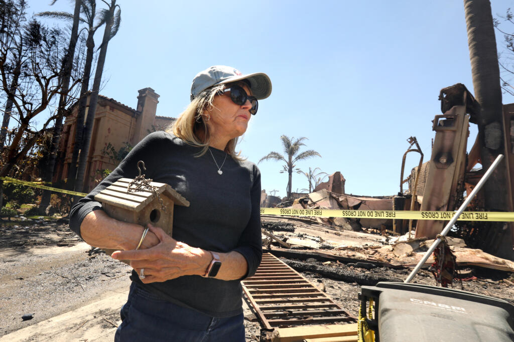
On Thursday, a day after the fire torched large swaths of the canyon, a gray haze hung over the charred hillside as residents returned to the community of Coronado Pointe.
As a firefighter trained his hose on the burnt remains of what had been a stately home in the gated enclave overlooking the canyon, 20-year resident Aimee Larr stepped out of her SUV and walked hesitantly to a string of yellow safety tape. She recognized the stone fountain in the frontyard.
“This was my house!” Larr said, voice trembling with emotion. “I can’t believe this. It’s completely leveled. Nothing is left.”
She recalled how Orange County Sheriff’s deputies called for neighbors to come out of their homes on Wednesday. Dressed in just sweatpants and a T-shirt, Larr left without medication or personal mementos.
When she returned Thursday afternoon, she held out hope that her house survived. After all, it was several thousand feet from the original blaze and the canyon her home overlooked was equipped with a sprinkler system that kept vegetation well-watered and green.
“I don’t know how fast it came to my house,” she said. “It was on the other side of the canyon, that’s why I had no big concern. I thought [firefighters] would drop something on it and it would be done.”
As of Thursday evening, the fire was 200 acres with 15% containment. Its cause remained under investigation, but Southern California Edison issued an initial report to state regulators saying that it had logged “circuit activity” around the time the fire started.