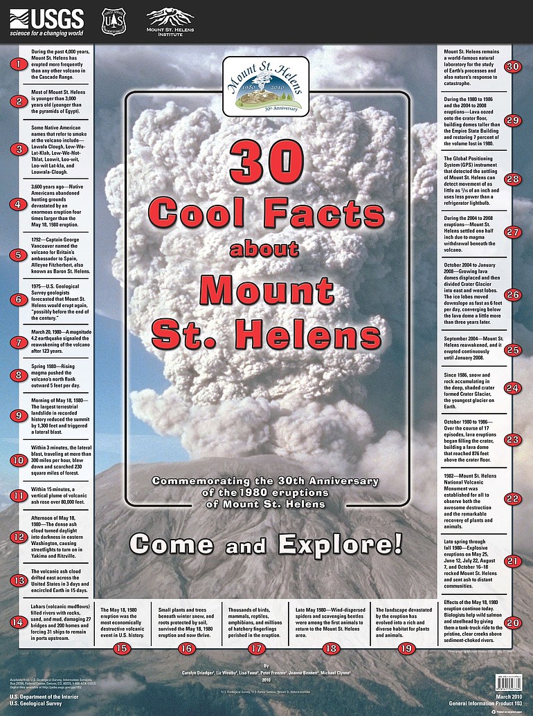
The eruption of May 18, 1980, reduced the summit of Mount St. Helens by 1,300 feet. But that was not the only geologic event that has reduced its profile. During its eruptions from 2004 to 2008, Mount St. Helens settled a half-inch because of magma withdrawal beneath the volcano.
Those are two of the items on a free new poster — “30 Cool Facts about Mount St. Helens” — commemorating the 30th anniversary of the 1980 eruptions.
o Posters are available during working hours at the Cascades Volcano Observatory, 1300 S.E. Cardinal Court, just off Tech Center Drive.
o They’re also available for a $5 shipping charge from USGS Information Services, P.O. Box 25286, Federal Center, Denver, CO, 80225; from 888-ASK-USGS; or from infoservices@usgs.gov.
o Posters are available during working hours at the Cascades Volcano Observatory, 1300 S.E. Cardinal Court, just off Tech Center Drive.
o They're also available for a $5 shipping charge from USGS Information Services, P.O. Box 25286, Federal Center, Denver, CO, 80225; from 888-ASK-USGS; or from infoservices@usgs.gov.
Carolyn Driedger, a U.S. Geological Survey scientist, said a few of the items came as news to some of her colleagues. Fact No. 6 reminds us that geologists forecast in 1975 that St. Helens would erupt again, possibly before the end of the century.
“The younger people here didn’t know that,” she said.
The first item says about our snow-capped neighbor: During the past 4,000 years, Mount St. Helens has erupted more frequently than any other volcano in the Cascades. (About 15 times, according to a USGS chart.)
Other items:
o The lateral blast on May 18, 1980, traveled at more than 300 mph.
o It was the most economically destructive volcanic event in U.S. history.
o Ash darkened skies in eastern Washington, causing streetlights to turn on in Yakima and Ritzville.
o The volcanic ash cloud drifted across the United States in three days and encircled the earth in 15 days.
As a scientist, Driedger appreciates Fact No. 28: A GPS instrument that is part of the monitoring network can detect movement of as little as one-sixteenth of an inch but uses less power than a refrigerator’s light bulb.
“It’s amazing, the precision. And the low power requirement is critical to leaving the instruments up there through the winter,” said Driedger, the project’s lead author. She worked with Liz Westby, Lisa Faust, Peter Frenzen, Jeanne Bennett and Michael Clynne in a partnership that included the U.S. Forest Service and the nonprofit Mount St. Helens Institute.
Driedger also likes the final item on the list, how Mount St. Helens is a world-famous natural laboratory.
It is “the most important volcano for study in modern times,” Driedger says. “St. Helens trained hundreds of volcanologists who then dispersed around the world to work on eruption hazard assessments and eruption response.”
And a cool fact that was not on the list: The photo on the poster is not from the May 18, 1980 eruption. It was taken on July 22, 1980.
“We wanted people to remember that May 18 was not the only event of the year,” Driedger said.