About 50 people showed up at a Vancouver hearing of the Washington State Redistricting Committee on Thursday evening, and a dozen offered opinions on how the five-member panel should redraw congressional and legislative district lines to reflect the results of the 2010 Census.
The bipartisan panel has until the end of the year to redraw the boundaries of all 49 legislative districts and reconfigure the state map to reflect the new 10th congressional district Washington gained as a result of a population jump of nearly 1 million between 2000 and 2010.
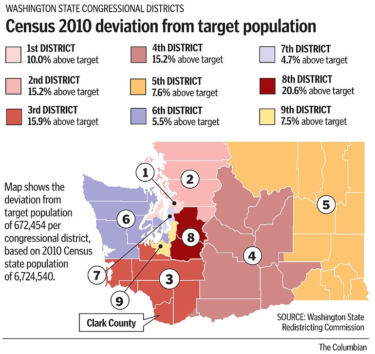
Fast-growing Clark County will see changes in both its legislative and 3rd Congressional District boundaries as a result of population growth, especially in the 17th and 18th legislative districts. The county’s population now entitles it to 3.2 legislative districts, said former U.S. Sen. Slade Gorton, one of four voting members of the commission. Under one scenario, the south end of Cowlitz County, now part of the 18th district, would become part of the 19th district to the north, forcing 18th District state Rep. Ed Orcutt, R-Kalama, to move or lose his seat in 2012.
Tashi Chogyal of Vancouver urged the commission to treat Southwest Washington’s 3rd Congressional District as its own distinct region as it redraws boundaries and said the district should not extend across the Cascade Range. The 3rd currently includes all but a small corner of Skamania County.
“The people of the 3rd represent a unique part of the state,” Choygal said. “We share a strong reliance on the interstate corridor, on trade, on fishing, on everything that comes down the river. We rely on Portland and on the Silicon Forest. I’m coming before the commission to urge you to stick to keeping all the districts as communities of interest.”
Under state law, the maps must be drawn to coincide with local subdivisions such as city and county boundaries and “communities of interest.” The districts are supposed to be “convenient, contiguous and compact” and provide fair and effective representation but also encourage electoral competition.
They are not supposed to be drawn to purposely favor or discriminate against any political party or group.
Ed Cote of Vancouver, a Democratic national committeeman, noted that as a result of redistricting between 1970 and 1980, Vancouver was placed in the 4th Congressional District, which covers a vast swath of central Washington. “It was not a good fit,” he said. “There is a rumor on the street that there is discussion of the city of Yakima coming into the 3rd District. I would be very opposed to that.”
Cote cited the need to build political support for the Columbia River Crossing as a reason to keep the district’s population center in Vancouver.
“We have a natural relationship with Portland, so we have to have a district that works with Portland,” he said.
Peggy Sutton of Camas seconded Cotes’ comments. “We have much more in common with Vancouver and cities along the I-5 corridor than we do with Skamania County,” she said. “Most of us are commuters. We would like to remain connected with those cities.”
Margaret Tweet of Camas said she feels no such affinity with Portland. “Actually, a lot of people move to Camas to get away from Portland,” she said. “I feel we do have a community identity,“ especially with Washougal and east Vancouver, she said.
Josephine Wentzel of notolls.com said issues like drawing boundaries to build political support for specific causes should not come into play in redistricting.
“We must not take politics into consideration,” she said. “If we have to join up with Eastern Washington, so be it. … Let the numbers decide.”
David Shehorn of Felida urged the commission to do its best to keep counties intact rather than split them across two or more legislative districts. He said the 18th District, which includes Camas, Washougal, Battle Ground, Ridgefield, north Clark County and south Cowlitz County is an example of a district that makes no sense.
“Legislative District is 18 is 1,200 square miles,” he said. “We go from one part of the river to another part 100 miles away.”
John Milem of Vancouver offered by far the most detailed proposals to the commission, complete with maps and explanations.
He proposes carving a new 10th Congressional District out of the state’s northernmost tier of counties, stretching from San Juan and Island counties in Puget Sound to Ferry County in northeast Washington. It’s only fair, he said, because over the past 40 years, Washington has gained two congressional seats, and both went to metropolitan Puget Sound.
Closer to home, his map has the 3rd District losing heavily Democratic Thurston County but gaining rural eastern Pierce County, including Mount Rainier National Park.
Milem’s legislative map envisions a more consolidated grouping of legislative districts in Southwest Washington, with the heavily Democratic 49th District extending north to include Felida, the 17th losing land to the north and expanding east, the 15th moving west, and the 18th encompassing La Center, Ridgefield and Battle Ground.
“This proposal has three districts within Clark County and for the first time in a long time it unites Cowlitz County in one district,” he said. Yacolt, Woodland and north Clark County would move to the 19th District.
Both the 49th and the heavily Republican 18th district would become more competitive politically under his plan, he said.
Milem, a retired chief financial officer for an offshore oil-drilling company, said he has spent the past year drawing the new maps, using state census estimates, actual census tract data and open source software.
Commissioners said anyone is welcome to submit maps and to purchase do-it-yourself redistricting kits from the commission for $25.
Kathie Durbin: 360-735-4523 or kathie.durbin@columbian.com.