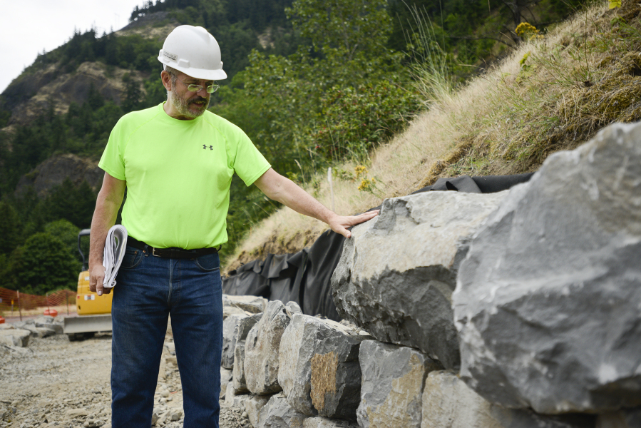
STARVATION CREEK STATE PARK, Ore. — Kelly Punteney has a keen eye for great rocks.
Most rocks don’t get the time of day from the Vancouver landscape architect, who points out irregularities and imperfections on chunks of rubble piled beside the freeway. Bumps and bulges have rendered these specimens 4-F. They’ll find some less-visible place in this project — but not this appealing wall near the trailhead.
Aesthetics aren’t the only problem. “Rockery” walls that don’t get mortared together need broad, flat slabs for stable stacking. Rules and regulations require it, Punteney noted, with specific weights and dimensions mandatory as you go from base to top — and with construction inspectors spot-checking the work almost daily.
“Keeping everybody happy is a challenge,” Punteney said. “You save yourself labor when you pick the right pieces up front.”
Punteney is the rock-project manager for Colf Construction, a storied Clark County firm and the general contractor now hurrying to complete a new, paved, 1.32-mile segment of the Historic Columbia River Highway and State Trail. That’s an ambitious, decadeslong, state-and-federal effort to reconnect and update the entire 74-mile length of the nation’s first scenic motorway, on the Oregon side of the Columbia River Gorge, as a paved, all-access route for use by long-haul cyclists and pedestrians. (Some segments will also remain open to motor traffic.)
The work has been incremental, based on available funding and the complexity of the engineering. It will be years before the last interruption in the old highway, which runs all the way from Troutdale to The Dalles, has been removed. When that does happen, former Hood River Mayor Arthur Babitz has predicted (in a promotional video at http://bit.ly/29VGa5D), the route will be transformed from “a series of day trips” for local residents to “an international destination” for visitors.
Meanwhile, this $3 million, 1.32-mile slice of the sprawling project — Lindsey Creek to Starvation Creek — is expected to open in September, with a dedication ceremony set for Sept. 24.
In addition to a 12-foot-wide paved surface, this segment includes basalt retaining walls and benches, circular viewpoints and improved trailheads, a 45-foot bridge over Warren Creek and lots of “flow-though” foundational rock work that lets water keep moving below while wheels and feet are rolling and strolling above.
Artistry, alas
The original 74-mile state highway from Troutdale to The Dalles, built between 1913 and 1922, was considered a miracle of roadway engineering for the ingenious way its twists and turns, rises and falls brought motorists face to face with waterfalls, rock walls, vast vistas and all the other amazing sights the Gorge has to offer. The highway’s visionaries, engineer Sam Lancaster and entrepreneur Sam Hill (famous for his Maryhill Museum building on the north side of the Gorge), were inspired by the high-altitude Axenstrasse highway, which traverses the Swiss Alps.
But beginning in the 1950s, the construction of a bigger, straighter, faster superhighway in the Gorge — which became Interstate 84 — meant either absorbing or simply abandoning some segments of the earlier, meticulously formed “King of Roads.”
“Alas, the road builders of the postwar period had little respect for the craft and artistry” that inspired that nickname, wrote author and journalist Kathie Durbin (who worked at this newspaper from 1999 to 2011), in her 2013 book “Bridging a Great Divide: The Battle for the Columbia River Gorge.” Even the most spectacular and daring engineering feats were forsaken, as a pair of highway tunnels that had been blasted through rocky cliffs between Hood River and Mosier — one 81 feet long, the other 388 feet and supplied with artful, arched windows — were decommissioned and refilled with rubble.
They weren’t destroyed, fortunately, and the historic trail restoration project took a huge leap forward when nearby rockfall catchments were built and the “Mosier Twin Tunnels” reopened to pedestrians and bikes in 2000.
Challenges ahead
The windowed tunnel at Mitchell Point, yet another engineering marvel and an early tourist draw in its own right, was destroyed — blasted out of existence to make room for the freeway. Today’s trail planners, facing the very same puzzles and possibilities as their predecessors for getting past this rocky bluff, are pondering whether to blast a new, longer and deeper tunnel through Mitchell Point — or build a viaduct, or connect with a remaining shelf in the rock up above.
“We have a whole series of alternatives” and much study left to do, said Kristen Stallman, a coordinator for the Oregon Department of Transportation.
More serious challenges remain. East of Mitchell, a section of abandoned highway called Ruthton Point clings to a steep slope just above the Columbia River; the plan is to restore that section exactly where it is. Farther west, the highway used to hug Shellrock Mountain, a sloping field of loose and jagged rock, but that section was absorbed by I-84; today there’s a wall and catchment fence protecting the freeway, and the plan is to squeeze in the new trail segment here by placing it up atop the wall.
Just east of that — and about 40 feet up — there’s an abandoned but beautifully woodsy section of historic highway nicknamed Mossy Road. Planners envision a new 800-foot viaduct that rises from the Shellrock segment to meet it; the eventual descent to meet the Lindsey-to-Starvation segment will require rock-wall blasting to form a new trail shelf. A $16 million grant from the federal government will launch that work later this year, Stallman said.
There’s no telling when the entire project will wrap up. One dream is the year 2022, Stallman said, because that’s the 100th anniversary of the completion of the original highway.
Kid rock
Punteney, 68, grew up “with rocks all around me” in Thermopolis, Wy., where his great-grandfather, a stonemason, worked in a quarry and built sandstone buildings.
The climate was harsh and windy, and if you wanted to grow anything in the soil, Punteney remembered, you built rock walls to shelter it. “You just gathered and stacked rock. It was part of life,” he said.
He was amazed to discover a field called landscape architecture, which became his major at the University of Oregon. “It seemed like a natural for me,” he said. He also earned a degree in parks and recreation management, and eventually spent nearly 36 years developing parks, trails and trail networks for Vancouver and the former Vancouver-Clark Parks and Recreation department. He also served as a state parks commissioner and, most recently, he has been pushing to preserve the Jane Weber Evergreen Arboretum, a historic property along the Columbia River, as a city park.
Punteney points to projects such as the Waterfront Renaissance Trail and the Burnt Bridge Creek Trail as his chief accomplishments, and added that this decadeslong effort to reconnect the historic Gorge highway reminds him of piecing together, across many years and many segments, the 8-mile-long Burnt Bridge Creek trail.
Now, Punteney works for Colf Construction. This year, he traveled frequently to quarries in Corbett and The Dalles to hand-select slabs of basalt for the historic highway project; when The Columbian visited this month, numerous subcontractors and other workers were busy building his babies into rockery walls, and chipping and chiselling other rocks for inclusion in a pair of circular, scenic viewpoints at Hole-in-the-Wall Falls. (Did you know? Hole-in-the-Wall Falls is an artificial diversion of the former Warren Falls, which used to overflow Warren Creek and flood the historic highway. In 1938, engineers chose to move the waterfall, not the road, and blasted a tunnel through a cliff here.)
“It’s a legacy project because it’ll be enjoyed by generations,” said Eric Brown as he positioned stones atop a slab. “It’s nice to be part of. And it’s not a bad spot to have your office.”
“It’s an honor to be able to work on something so important to our region,” Punteney said. “I’ve been all around the world, but this is such a special place.”