BAINBRIDGE ISLAND — The Bainbridge park district is trying a high-tech solution to the age-old problem of finding injured hikers.
The district is installing rescue locators in its forested parks and across its growing network of interconnected trails.
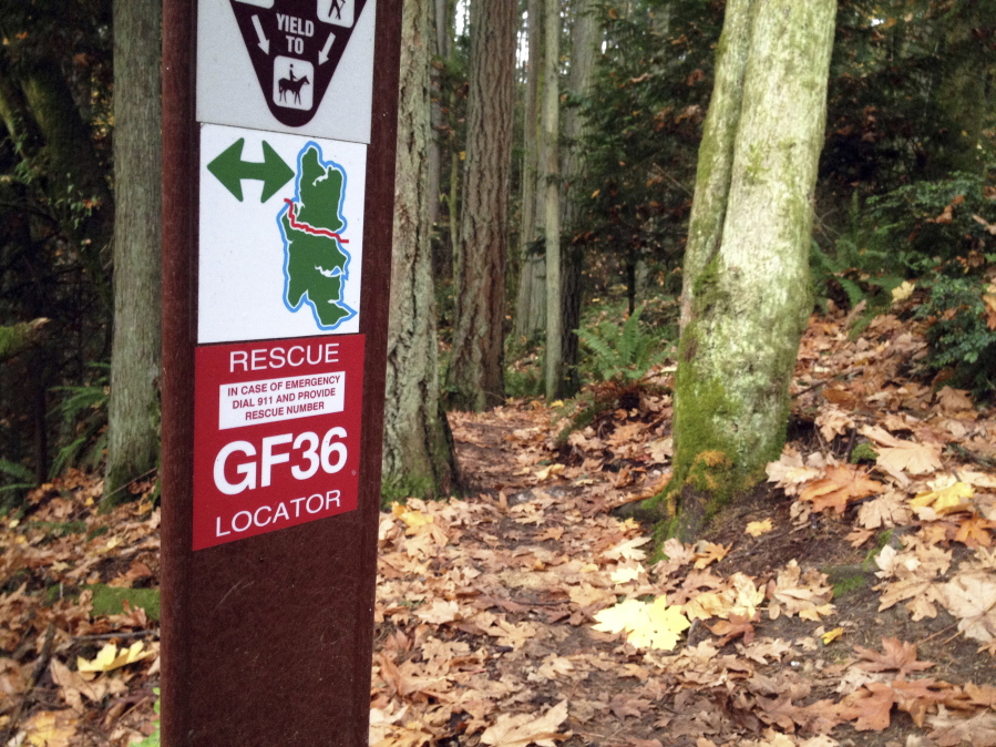
If a hiker twists an ankle or a mountain biker crashes, a 911 caller can tell the dispatcher the number on the nearest locator. Each locator is coded with GPS coordinates that emergency responders can use to zero in on the injured person, reported the Kitsap Sun.
“Now, emergency personnel know exactly how to get to them, cutting down their response time to a minimum,” said Dan Hamlin, park services director.
The first 30 locators were installed in Grand Forest Park, a 240-acre swath of woods with 6 miles of trails and several trailheads. People regularly get lost in the park, spurring the district in 2014 to try another techie fix: trail markers that activate smartphone maps.
The district’s rescue locator program is the first of its kind in the county. It was borne out of a recent tragedy and a near-tragedy.
Two years ago, a group of friends were hiking Grand Forest when a man in their party suddenly keeled over.
A frantic 911 caller was clear about the emergency: heart attack. But the other critical detail — location — was unknown.
“It was very confusing because they didn’t know where they started and they didn’t know where they were,” said Luke Carpenter, the Bainbridge Island Fire Department’s assistant chief. “We had all these units running around trying to find this individual.”
It was fortunate for the hiker that a CPR-trained park employee happened to be working nearby. He kept the hiker breathing until an ambulance crew eventually located them.
Four months later, Bainbridge middle school mountain bike coach Jay Abbott suffered crippling injuries during a training ride in the park. He died four days later.
“It was a tragic outcome,” Carpenter said. “I put the onus on the park district, and said: ‘Folks, you got any ideas to help us find people? Because I don’t.”‘
Park staff did have some ideas, thanks to a training hosted by American Trails, a California-based trails advocacy group.
“It was a webinar about trail signage, but there was some mention about these rescue locators,” Hamlin said. “It seemed like just the thing we needed.”
Sometimes a big fix comes easy and cheap.
Recording coordinates for the 30 locater sites simply required staff to take a few hikes with a GPS unit.
Dozens of trail markers already were installed, so there was little added cost.
“It was pretty inexpensive — just buying some decals,” Hamlin said.
Total cost: $60.
Bringing CENCOM, the county’s 911 service, onboard was surprisingly uncomplicated. CENCOM simply plugged the 30 sets of coordinates into its own locator system.
“They were great,” Hamlin said. “They just loaded them right in. That was it.”
Beyond Bainbridge, the rescue locator system is not yet widely used. One early adopter was the TRACKS trail group in northeast Arizona. The group’s volunteers installed hundreds of the GPS-coded markers across the 200-mile White Mountains Trail System in 2013.
Volunteer Nick Lund said rescues used to take hours. Now they’re typically completed in under 45 minutes.
The Grand Forest system has been used at least once since it was activated during the spring.
“It was a sprained ankle, I think,” Carpenter said. “It wasn’t a significant event for us because we found them so easily.”
The district plans to expand the system to the 445-acre Gazzam Lake Preserve, which links Fort Ward and Blakely Harbor parks.
“We have so many trails that are interconnected and go long distances,” Hamlin said. “People might know where they left from, but they have no idea where they are when they call.”
Carpenter said his department is grateful for the help.
“When seconds count, we have to know where a patient is,” he said. “This has proven to help us do our job.”