Gifford Pinchot (1865-1946), the first chief of the U.S. Forest Service, was the sort of middle-of-the-road thinker it’s hard to find in government today.
He coined the term “conservation” as we now apply it to natural resources and the environment. But the moderate policies he favored weren’t total protection and preservation in service of today’s green ideals; Pinchot was an early proponent of scientific forest management and “continuous cropping” of timber to benefit humanity.
But when he beheld industrial-scale clear-cutting in the Pacific Northwest, he was appalled. “Absolute devastation,” he wrote. “The Forest Service should absolutely declare against clear-cutting in Washington and Oregon.”
That didn’t happen, but in 1949, the 1.32-million-acre forest that straddles five Washington counties (Skamania, Lewis, Yakima, Cowlitz and Klickitat) was renamed, from the original 1908 Columbia National Forest, to honor the forestry pioneer.
The Gifford Pinchot National Forest is a sprawling and diverse network of unique geologic sites, stunning vistas, protected forests and people-friendly facilities for camping, hiking, horseback riding and even mountain biking and motorcycle riding.
Here are five great ways to get to know the GP. Don’t forget that you usually need to pay a day-use fee (or display your Northwest Forest Pass or other valid federal interagency recreation pass) when you park.
More information is available at www.fs.usda.gov/giffordpinchot.
Huckleberry harvest
In keeping with Pinchot’s managerial spirit, this year huckleberry picking is permitted. Literally.
Huckleberries are huge in the GP — big, sweet, red and blue and purple. But decades of harvesting by tourists has taken a toll on lands still governed by treaty with local tribes. To keep local berries sustainable and plentiful, the Forest Service and local partners are working on various huckleberry restoration and data collection projects.
So, as of this year, every single harvester of huckleberries must carry a permit — even if you’re just snacking as you hike along. That may seem extreme, but the permit is free and you can print it via apps.fs.usda.gov/gp. You must have this “free use” permit with you as you pick any amount of berries, up to a gallon per day or 3 gallons per year. (More than that makes you a commercial picker and requires a “charge use” permit, which isn’t free.)
“To maintain the crop of huckleberries for now and for generations to come, the Forest Service needs to know how much huckleberry harvest is occurring,” said Forest Supervisor Gina Owens.
Great views, bad road
Everybody knows that nearby active volcano with the sheared-off top. Mount St. Helens is the attention hog of the GP.
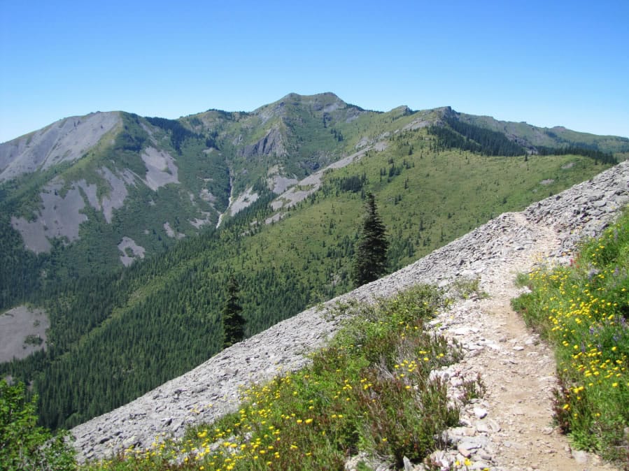
But closer to home is an extinct volcano to our east: Silver Star Mountain. Named for the five ridges that radiate from its summit, it went down in history as the center of the legendary 1902 Yacolt Burn, the largest fire in state history for more than a century. Because of rock slides caused by that blaze, new forests never took hold on Silver Star’s slopes, which are now ruled by dazzling fields of high-altitude spring and autumn wildflowers.
Your only challenge in seeing those flowers, and other amazing views, is actually getting up there. No problem taking Sunset Falls Road east from Moulton Falls Park and turning onto Forest Road 41, but hiker reports to the Washington State Trail Association confirm that Forest Road 4109, which gets you to the nearest trailhead to the peak, is “one of the worst roads in the state of Washington” and not recommended for any but the toughest high-clearance utility vehicles.
Underground cool
Summer heat driving you ape? Try some cool spots below Mount St. Helens. Take Lewis River Road east from Cougar to Forest Road 83. First, stop at the Trail of Two Forests for an educational, accessible walk (on a paved trail and boardwalk) among the lava casts and ancient imprints left behind when lava flows buried one forest, thousands of years ago, and another grew on top of it.
Ape Cave is a little farther up the road. (It was never a lair for monkeys; the Boy Scout troop that explored the place in the 1950s was the St. Helens Apes.) There’s a remodeled visitor center and a paved path to the mouth of the Lower Cave, where you descend a staircase into darkness. At 2.5 miles, Ape Cave is the third-longest lava tube in North America; you can spend hours among its fascinating formations and darkness-loving creatures (such as crickets and fungus gnats). Really intrepid spelunkers can even get down on their bellies to wriggle and squeeze though some tight blind alleys. There’s an Upper Cave too, which is even more challenging and rewarding — and, alas, more disfigured by graffiti.
How cool? It stays 42 degrees down there. Wear warm clothing. Bring two light sources; you can rent a lantern at the visitor center.
Wilderness by law
The 1964 Wilderness Act formally extended the highest level of federal protection (basic recreation and camping OK, but no permanent development and no vehicles of any kind) to certain natural zones; in 1984, the Indian Heaven Wilderness became one of them. It’s a 21,000-acre plateau with dozens of volcanic cones, hundreds of little lakes, countless wildflowers and countless-plus-infinity hungry mosquitoes. This is prime berry-picking country; local elk, deer and black bears know it. The Pacific Crest National Scenic Trail crosses the entire area, north-south for 16.4 miles, with many side trails.
Take state Highway 14 to White Salmon and state Highway 141 to Trout Lake. Continue 16 miles on Forest Road 24 past Little Goose Campground to the Cultus Creek Campground and trailhead.
Water in the sky
The Midway High Lakes are all beyond 4,000 feet elevation: Five gleaming bodies of water, plus 12 more in a “Chain of Lakes,” on a plateau northwest of Mount Adams. Camping, fishing, horseback riding, hiking and mountain biking abound among meadows, marshes and impressive lava flows. Spectacular views reward hikers on Trail No. 116, a historic Yakama Indians berry-picking route.
Head south from Randle on state Highway 131 (Forest Roads 23 and 25); then follow Forest Roads 2329 and 5601 to the trailhead.