<img height="1" width="1" style="display:none" src="https://www.facebook.com/tr?id=192888919167017&amp;ev=PageView&amp;noscript=1">
Sunday,  May 5 , 2024

Linkedin Pinterest
News / Life / Clark County Life

Greetings from Mount St. Helens

Boston native finds much to appreciate at - and to, from - volcano

By Sue Vorenberg
Published: June 9, 2012, 5:00pm
6 Photos
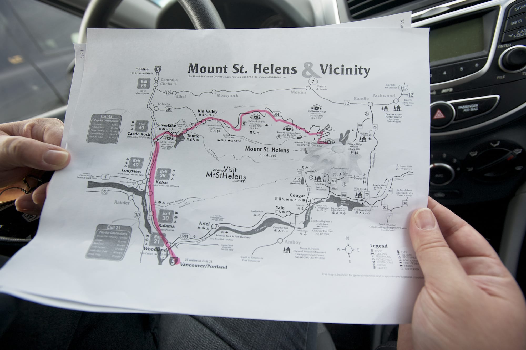
The map I downloaded didn't show most of the kitsch roadside attractions on the way to Mount St.
The map I downloaded didn't show most of the kitsch roadside attractions on the way to Mount St. Helens. Photo Gallery

As a 10-year-old Boston kid, the 1980 eruption of Mount St. Helens seemed somewhat remote, but it’s always fascinated me.

The images of knocked-over trees and the massive ash plume — not to mention half the mountain blown away — are hard to forget, as is the death toll.

Being a region-centric New Englander, it was probably the first time I realized the Pacific Northwest existed, or that there were active volcanoes in the United States.

Now, 32 years, a few cross-country moves and a geology degree later, that impressive and active volcano is just a stone’s throw from my house.

If You Go

Getting there: From Vancouver, take Interstate 5 north to exit 49 and the town of Castle Rock, then take a right onto the Spirit Lake Highway. Follow the signs to the observatory. It takes about an hour and 45 minutes to get there without stopping.

Dates: May 13 - Oct. 28.

Cost: $8 per person for the Johnston Ridge Observatory.

Things to remember: Sunscreen, sunglasses, water bottle, hiking shoes, camera, binoculars, layered clothing, jacket. There's still snow around the observatory and it can get windy.

Other attractions on Spirit Lake Highway: Mount St. Helens Visitor Center at Silver Lake, with information on the region's culture, history, geology, plant and wildlife; Forest Learning Center, with information on the natural history of the park, forest recovery, reforestation and conservation; and Mount St. Helens Science and Learning Center at Coldwater, which is a staging area for science groups and school trips.

Other information: You'll find several spots along the road advertising helicopter tours. Also there are some great viewpoints past the Hoffstadt Creek Bridge. Check out this free map.

No, make that a dacite pyroclastic rock throw from my house.

I visited the mountain once before with a friend in 2003, but we didn’t stop for long and I hadn’t been back, not even after moving here from New Mexico two years ago.

So when my editor proposed a first-person day-trip story it seemed like a great chance to explore and see how the place has changed.

First up, though, I did what most journalists would do — I found breakfast and coffee.

On the way to Johnston Ridge

The drive up to Johnston Ridge Observatory on the Spirit Lake Highway has its share of strange, kitschy attractions — including a giant cement Bigfoot statue, a buried house and a mysterious dirt raceway.

Not to mention you can’t swing a dead Sasquatch without

hitting one of the many visitors centers and gift shops.

Before that, though, the El Compadre Restaurant in Castle Rock beckoned with Chorizo Con Huevos — which is basically Mexican sausage and eggs.

The dish was hearty, tasty and a little spicy, although not by New Mexican standards. The salsa was a little heavy on the tomato, but had a good amount of spice, and the coffee was nice and smooth.

In short, everything a reporter needs to solve the “too much blood in my caffeine system” problem and get on the way.

Driving along the small highway, it’s hard to avoid gasping at the intense scenery. There are deep gray canyons of muddy ash flow and whitened knocked-over trees all across the landscape after you pass the “Entering Blast Zone” sign by the Hoffstadt Creek Bridge.

It’s a strong reminder of just how powerful the explosion was.

Geology students often have an unhealthy obsession with road cuts (which are rock layers cut through by a highway department in order to build a road), and I’m no exception.

Even with a quick glance at them along the drive, you can see different-colored rock types that were spewed out by the volcano over its history, including black, clumpy basalt and a gray pumice-like rock called dacite.

The observatory

Just outside of the Johnston Ridge Observatory building, named for David Johnston, a volcanologist who died in the May 18, 1980 explosion, is a stunning view of the snow-capped caldera and mountainside. While there I caught a brief part of a ranger’s discussion with a tour group.

“Wouldn’t this be the ideal place to build a vacation home? Right at the base of the most active volcano in the lower 48?” he asked.

Stay informed on what is happening in Clark County, WA and beyond for only
$9.99/mo

The group of about 25 people couldn’t take their eyes off the shattered peak with the new, slowly expanding bulge of volcanic material growing in its center. Around the bulge is a newly forming glacier, the only one in the continental U.S. that is still growing.

On the left side of the observation deck is a walkway that leads to some even more fantastic views of the muddy gray ash-filled valley and rows of downed trees that remained after the event.

At around 4,000 feet the altitude wasn’t particularly strenuous, and I’m certainly not in great shape, but it could still wind somebody not used to mountainous terrain. The walkway includes several displays about magma, stumps, landslides and ash plumes along with pictures of the mountain before and after the explosion.

There’s something fascinating about two layers of the place — the large fiery destruction that blasted through the valley, killing 57 people and sending an ash plume into the sky that covered buildings and cars even a few states away, and the smaller things like the chunks of volcanic rock you can hold in your hand or the white bleached trees and stumps that you can reach out and touch.

The ranger

Peg Bohan, a park ranger and geologist, showed me some of the small crystals inside the dacite and other rock that formed inside the mountain. If you look closely at a chunk of it you can see flecks of green olivine, white feldspar and black biotite and hornblende.

The volcano has erupted many times in its history, but it’s only had one basalt eruption since it formed about 40,000 years ago, she said.

That flow, about 2,000 years ago, created the Ape Cave lava tube on the other side of the mountain. At more than two miles, it’s the longest lava tube in the continental U.S.

Basalt is a fairly dense rock that flows easily from a volcano and isn’t generally associated with eruptions like the 1980 blast.

But underground basalt can merge with other rock to turn into the more explosive dacite rock that filled the air when the mountain exploded.

The magma, which is deeper in the earth, changes composition as it moves through lighter-weight rocks made of sand or quartz closer to the land surface. It melts those rocks into it, which makes it flow more slowly and bottle up — creating the potential for explosive eruptions.

Volcanic flows have different consistencies, depending on the mix of basalt and sandy quartz rocks. The most easily flowing lava is basalt. After that is a slower-flowing, sometimes explosive rock called andecite, followed by dacite and finally rhyolite.

“So those rocks, the way they flow, basalt flows like water, andecite flows like honey, dacite flows like toothpaste and rhyolite flows like peanut butter,” Bohan explained. “Our lava here is about a million times thicker than Hawaiian lava. It flows like toothpaste, it builds up and then explodes.”

The Mount St. Helens mix is about 65 to 67 percent silica to basalt, for those of you playing at home.

White trees

The white color and preservation of the dead trees and tree stumps around the site seems almost unnatural — and there’s a reason for that.

The blast area includes three zones of tree damage. In zone one, closest to the eruption, the trees were vaporized and nothing survived.

In zone two, the tree blowdown zone, limbs and bark were obliterated and trees were knocked over. And that’s where the odd color comes into play.

In that zone, ash from the mountain blasted into the timber, almost petrifying it. So the trees are that white-gray shade because they’re saturated with ash and also cooked from the volcano’s heat and then sun baked for many years.

In zone three, called the standing dead forest, trees were stripped of bark and baked, but remained upright.

If you go into the observatory, there’s a large tree in the main room where you can take a closer look at the ash-blasted remains of one of the trees.

The stumps around the explosion zone also have a somewhat unusual story. They pre-date the eruption, and were a product of logging in the area. They were covered by snow during the eruption, which protected them from being obliterated during the blast, Bohan said.

The trip back

With short films, a host of displays and scientific data and equipment — not to mention patient rangers ready to answer questions — there’s a lot to check out at the observatory.

But by around 4 p.m. it was time to head back, especially considering the giant Bigfoot statue that was calling to me.

The 28-foot-tall statue, at the North Fork Survivors Gift Shop in Kid Valley, is hard to miss, even when you’re driving at about 50 mph. And, because one of my rules of life is “never pass up the chance to do something goofy,” there was no way I could avoid stopping to get my picture taken with it.

If that’s not enough goofiness though, the statue also has a smaller plywood friend, with an image of Bigfoot holding a coffee cup. Inside the gift shop was lots of Bigfoot memorabilia — along with the usual array of Mount St. Helens ash containers. I was tempted by some of the funny T-shirts, like one that read “World’s Biggest Ash Hole,” but this is a family paper, right?

Even if you pass up the other attractions, don’t skip Patty’s Place at 19 Mile House, which is just a turn or two down from Bigfoot.

From the front, it looks like a typical tourist restaurant. But if you go through to the tables on the back porch, you can try one of their eight varieties of homemade cobbler with ice cream while looking out over a gorgeous cliffside view of the Toutle River.

I had the raspberry peach cobbler, which was all kinds of tasty without being too sweet. And the restaurant’s organic coffee was a great boost before the rest of the drive home.

Support local journalism

Your tax-deductible donation to The Columbian’s Community Funded Journalism program will contribute to better local reporting on key issues, including homelessness, housing, transportation and the environment. Reporters will focus on narrative, investigative and data-driven storytelling.

Local journalism needs your help. It’s an essential part of a healthy community and a healthy democracy.

Community Funded Journalism logo
Loading...