GRANTS PASS, Ore. — It’s a vacant lot now, with almost nothing left but an aging concrete slab and septic cap. It’s where Skeets and Bobbie Bellamy and their three sons lived on Fielder Lane, after escaping the Los Angeles traffic in 1959.
A redwood, planted by Mike Bellamy when he was 6 years old, soars upward. The Rogue River flows about 250 feet in the background.
The family endured a flood in 1962. It was not catastrophic. They just moved everything upstairs, said Mike Bellamy, now 60, of Grants Pass.
But nothing prepared them for what unfolded two years later when the Rogue River went on a rampage, swollen with record rainfall and melting snow.
Early Wednesday morning, Dec. 23, 1964, as the river crested, a large tree smacked into the Bellamy home and obliterated most of it. Luckily they were not in it.
The Flood of the Century had swallowed another victim.
That flood set the bar for every other flood on the Rogue River. The only larger ones in modern times had struck in the 19th century.
“Years later you look for things you had, and you know they went down the river,” Skeets Bellamy said in a 1984 Daily Courier article.
The “Big One” crested at 34.15 feet, 14 feet above flood stage and nearly 2 feet higher than the 1955 flood that set in motion the construction of Lost Creek, Applegate and Elk Creek dams in the Rogue basin. (On today’s gauge the flood crest would be 35.15)
Many people were stunned by the Jan. 1, 1997, flood. It was 10 feet lower.
Today, Lost Creek Reservoir’s storage would have knocked off 25 percent of the peak flow in Grants Pass, but the river would have still risen at least 8 feet above flood stage, according to the U.S. Army Corps of Engineers.
The monster flood came about like most of the Rogue floods over the years, the double whammy of heavy rain on top of significant melting snow. It affected every river in Western Oregon and northwestern California.
The morning of Dec. 23, Margaret Slagle of Grants Pass loaded her four children and an 8-millimeter movie camera to record the event. Her husband, R.B., who would have a long career in the log truck business, drove the car.
Joan Momsen of the Josephine County Historical Society earlier this week popped in a DVD made from Slagle’s home movie, and relived the wild flood. The DVD is available for $10. Snippets of it are on the Daily Courier’s website.
“Trees would hit the Seventh Street bridge and go under, then pop up between the bridges, then hit the side of Caveman Bridge and shatter,” Momsen recalled.
Slagle filmed trees slamming into the bridge at Rogue River, and in the background swamped businesses along Rogue River Highway. Gail’s Market was one that suffered extensive damage in both the ’55 and ’64 floods. From Foothill Boulevard, the view is down to the flooded railroad tracks and devastated Fielder Lane.
“My goodness, we saw houses go by and all kinds of things,” said the 81-year-old Slagle, during an interview earlier this week.
Perhaps most impressive were the scenes she filmed at Hellgate Canyon 18 miles downstream from Grants Pass.
“Oh my goodness, the power behind all that water going through such a narrow place,” she said.
Her son Mike, now in his early 60s, still points out the high points of the ’64 flood when he’s guiding on the Rogue for Orange Torpedo Trips, including a spot not far below where the Hellgate overlook is today.
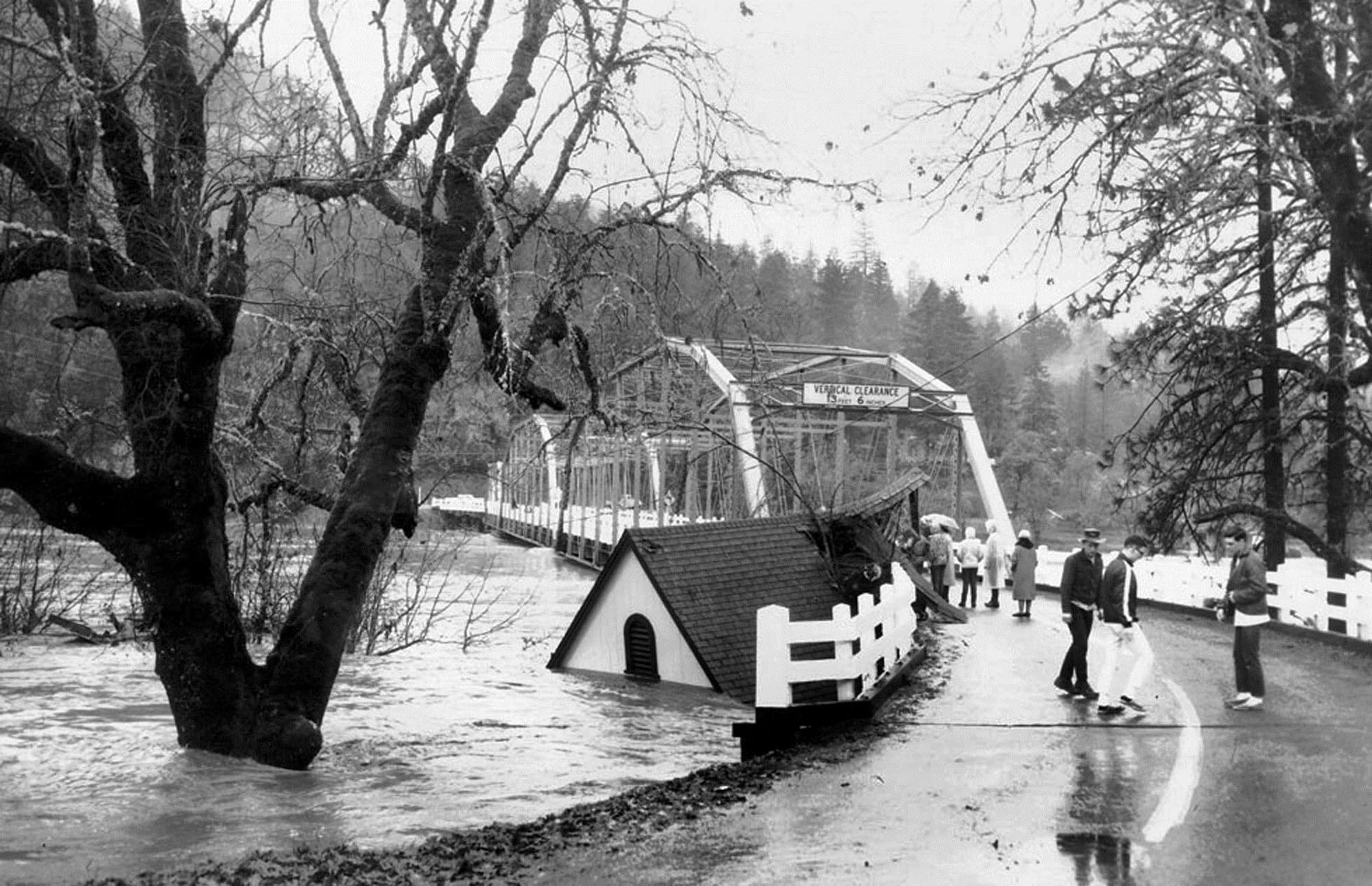
A few miles upstream, the Rogue topped the pavement at Robertson Bridge. Two houses slammed into the bridge and were pinned against it.
Ray Slusser said his wife, Jan, was in her early teens living on Merlin-Galice Road, on the property they live on now, and got stranded by the flood.
“Jan had a friend out for the weekend, and the flood hit. They were running out of supplies, and water was still up over the road,” Slusser recalled. “Her dad figured they could walk to Merlin. They started walking, and they made it up to their armpits.”
Farther upstream, the flood wiped out the highway bridge at Shady Cove and damaged Dodge Bridge on the east edge of Sams Valley.
In Josephine County, 10 bridges were destroyed, including the Redwood Highway bridge over Rough and Ready Creek south of Cave Junction. Sauers Flat near Kerby was a disaster scene, with several houses destroyed.
Daily Courier reporter Ruth Rausch’s house on Rogue River Highway was flooded, marooning her. She wrote about the aftermath.
“Mud and slime, the consistency and color of thick, chocolate syrup, and tons of silt loaded with debris of every imaginable description spells out the aftermath. Refrigerators, ranges, cabinets, gas tanks, houses, trees, logs, barrels, barrels and more barrels all at crazy angles, raced before the angry waters at dizzying speeds.”
Momsen recalled the story of a house perched along the Rogue River upstream of Hog Creek and Hellgate Canyon. A couple was inside, with two feet of water flowing through.
“They felt like something wasn’t right. They went outside to look, and the house just disappeared. They never found anything of it,” Momsen said.