WEST GLACIER, Mont. — Monday’s weather was a mix of good and bad news for firefighters working in Glacier National Park.
Some rain fell in the West Glacier area, offering a brief respite from the smoke, but there wasn’t enough precipitation to have much of an effect on a lightning-caused fire burning northwest of Lake McDonald.
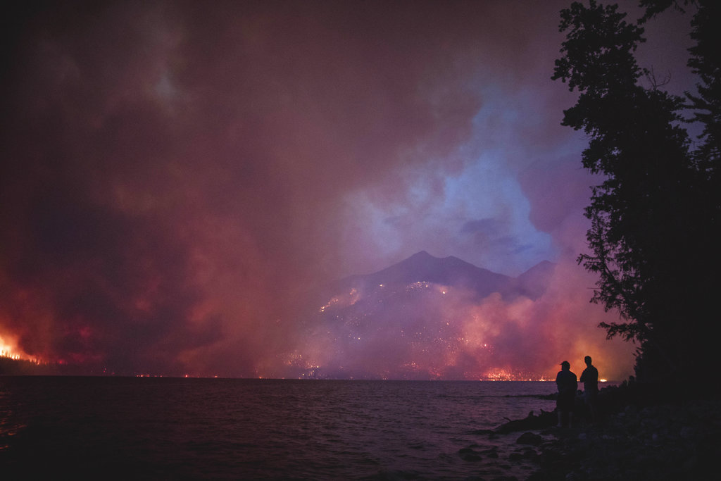
“It’s nothing to write home about,” fire information officer Chris Wyatt said Monday of the rain that fell on the 12.5-square-mile (32-square-kilometer) Howe Ridge Fire.
Unsettled weather is forecast for the next few days with the possibility of thunderstorms and wind gusts up to 35 mph (56 kph) on mountain ridges.
While the wind typically blows from the west, the latest front is moving in from the northeast, which could push the fire toward Apgar Village at the southern edge of Lake McDonald. An evacuation warning was issued for the village Sunday and the Flathead Beacon reports most people left.
The fire, which made its first big run on Aug. 12, burned actively Sunday night into Monday after winds pushed it into trees killed by a 2003 fire, officials said. However, fire managers did not fly the fire overnight to get an updated size.
Firefighters are using hoses and sprinklers to try to prevent the fire from moving closer to the scenic Going-to-the-Sun Road northeast of Lake McDonald.
The mountain road remained closed from the foot of Lake McDonald to Logan Pass. The Logan Pass visitor’s center is open, with shortened hours from 9:30 a.m. to 4 p.m. Going-to-the-Sun Road was open from the pass to St. Mary, park officials said.
Elsewhere, some residents near the southwestern Montana town of Ennis were allowed back into their homes after being evacuated for more than a week due to two wildfires that have burned nearly 17 square miles (44 square kilometers) of land.
Meanwhile, smoke from fires in northwestern Montana, the Pacific Northwest and British Columbia led Montana’s Department of Environmental Quality to issue an air quality alert in parts of western Montana.
The air was unhealthy in parts of northwestern Montana at midday Monday and unhealthy for sensitive groups in much of southwestern Montana. Rain had helped improve the air quality to moderate in central Montana.
Monday’s haze was nowhere near as bad as last summer when fires burned around the Seeley Lake area, trapping smoke in the valley between the Rocky Mountains and the Mission Mountains.
The town had hourly pollution readings at the hazardous level during 26 days in August 2017, in many cases topping out the ability of the equipment to measure the level of pollution.
“There aren’t even the correct health categories to describe what they’re seeing,” Missoula County air quality specialist Sarah Coefield said at the time.