Volunteers and work crews continue to repair the damage caused to trails on the Oregon side of the Columbia River Gorge by the Eagle Creek Fire of last summer. Progress is being made and several trails have reopened during the last two months. More trails will reopen this summer.
Meanwhile, hikers that would normally be on the Oregon trails continue to put extra pressure on trails on the Washington side.
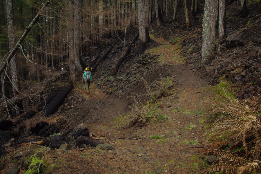
The Eagle Creek fire was started on September 2, 2017, when a Vancouver youth tossed a smoke bomb into the forest along the Eagle Creek Trail. The fire eventually burned for three months and charred over 55,000 acres.
Max Martin is a volunteer from Boston who has been working on trail recovery with members of the Mount Hood Chapter of the Pacific Crest Trail Association (PCTA) for the past three weeks. What he has seen has impressed him.
“The coordination between the Forest Service and the volunteer groups kind of blows me away,” said Martin. “The (volunteer) interest in it is astounding.”
He reported that the Mount Hood Chapter of the PCTA has logged over 12,000 volunteer hours in just a few months. And, they are just one of the many groups that have partnered with the Forest Service and contributed to the restoration efforts.
The PCTA is one of four organizations that form the independent Gorge Trails Recovery Team. The team also includes the Friends of the Columbia River Gorge, the Trailkeepers of Oregon, and the Washington Trails Association.
There is also a long list of other groups that have partnered with the Forest Service and are doing good work on the trails.
Many areas within the Gorge will take years to heal, but that process is already starting.
Martin said that some of the less-burned areas are beginning to green up with the arrival of annual plants. Non-native bracken fern and native plants such as Oxalis and Trillium are already colonizing parts of the burn.
Other, more severely damaged areas are still pretty much a wreck.
PCT, other trails reopen
Just recently the Pacific Crest Trail was re-opened. Hikers can now hike the PCT all the way through, although there are some rules to protect hikers.
“There are still some restrictions,” Martin said. “You have to camp within 25 feet of the trail.”
Serious hazards exist just off the trail, and the restriction is meant to keep people from venturing into areas that are still dangerous.
Newly reopened trails on the Oregon side also include the Herman Creek Trail, and a network of other trails that are more remote and go into the Mark O. Hatfield Wilderness.
There are about 140 miles of trails within the Columbia River Gorge and the Mount Hood National Forest that were affected by the Eagle Creek Fire. Of the more than 90 miles of damaged trails within the Gorge, about 60 miles have been reopened.
The trail to Benson Bridge at Multnomah Falls is expected to be open by the end of this week.
Of the remaining closed trails, those west of Multnomah Falls should reopen by the end of 2018. These should include Angel’s Rest, Devils Rest, and the Wahkeena Trail. The Larch Mountain Trail should reopen as well. For trails from Multnomah Falls east to Cascade Locks, the most heavily burned area, there is no timetable as yet for recovery.
Shifting to Washington
With so many popular trails in Oregon closed, hikers are spending more time on the Washington side of the Gorge, and that has added to crowding on the most popular trails.
Heath Yeats is the assistant manager of Beacon Rock State Park and he said the park has seen a big increase in hikers.
“Yes, we have seen more traffic,” said Yeats. “For the month of May we were 40% over our normal day use.”
He encourages people to visit during the middle of the week to avoid the crowds. “Parking is an issue on the weekends,” he added. “We will probably continue to see that increase through the summer.”
Some Washington trails are very popular and have always had traffic issues even before the Eagle Creek Fire. The situation has made the congestion worse.
For instance, the Dog Mountain Trailhead is the jumping off point for a number of very popular trails, and parking in the small lot has always been a problem. The influx of new visitors is making the situation more difficult.
Hikers still need a Dog Mountain Permit to hike the trail until July 1 on the weekends, including this Saturday, June 30.
Other popular trails, such as the Cape Horn Trail, will undoubtedly also see increases in traffic this summer.
If you go
Hikers can still get their kicks in the Gorge, but agency managers offer suggestions for reducing the congestion. Rachel Pawlitz, the public affairs officer for the US Forest Service, Columbia River Gorge National Scenic Area, offers these suggestions:
“We ask hikers to go early, before 10 am,” she said. “Go mid-week if possible, and head to trails further east if possible, as those tend to be less crowded. Be courteous. Don’t park unless there is a spot and it is safe to do so. Don’t block parking spots or private driveways, and don’t park in unauthorized spaces. You can reduce carbon emissions and congestion by carpooling, taking a shuttle or biking.”
Volunteers still needed
There are plenty of volunteer opportunities for hikers that wish to help with the restoration. Potential volunteers can contact the forest service, or one of the partner groups.
Hikers can check out the progress or volunteer by going to the PCTA website at: www.pcta.org
More information is available on the Columbia River Gorge National Scenic Area website.
Less-crowded hikes in Washington
Listed here are a few less-crowded options for hikers this summer.
The Klickitat Rail Trail
This former railroad bed trail follows the Klickitat River for 31 miles. There are numerous access points along State Highway 142, so you can find a hike of about any length you want, and the scenery of the Klickitat River and the canyon is extraordinary.
Wildlife is another reason to hike this moderately-used trail. Keep an eye out for mule deer, wild turkey, western gray squirrels, and more.
Klickitat Rail Trail, Swale Canyon
This off-shoot of the main Klickitat trail takes hikers up the Swale Creek Canyon. The hike is about 13 miles one-way, and offers some excellent views and solitude for out-and-back hikers.
Start at Harms Road and follow Swale Creek downstream as it approaches the Klickitat River. The old railroad bed is wide, making it easy to share the trail with the occasional mountain biker.
This is lonely country, with windswept vistas that narrow as you enter the canyon. Again, wildlife is abundant.
Salmon-Morgan Creek Trail
This short trail near Battle Ground is a great hike for kids, and it takes about one hour to hike. There are creeks for the kids to play in as you hike through mature forests and meadows.
Not easy to find and nestled near a modest neighborhood, it is not that well-known.
Directions: From I-5, take exit 11 for Hwy 502. Turn east onto 502, and proceed to a ‘T’ junction with Hwy 503 (Also signed as SW 10th Ave). Turn right here, then left onto SW Eaton Blvd, then turn onto NE 142nd. Follow this to a ‘T’ intersection then turn left, proceeding a short distance to NE 152nd Ave. Turn left, or north on NE 152nd Avenue to NE 181st Street and turn right on NE 181st Street. Continue to NE 159th Avenue. Turn left on NE 159th Avenue to NE 183rd Street. Park at either trailhead.