Sometimes, Central Oregonians with a passion for both hiking and biking like to take on both disciplines in the same day.
Luckily, our region is filled with areas that offer the chance to do just that.
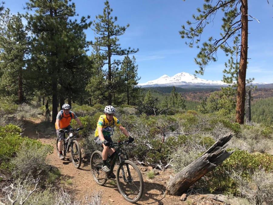
One such area is just south of Sisters, Ore., which is home to the Peterson Ridge Trail system and Upper Whychus Creek.
Peterson Ridge includes 30 miles of expertly designed singletrack and seemingly endless loop options for mountain bikers.
Just a few miles up Forest Road 16, the Chush Falls Trail features a 5-mile round-trip hike to spectacular Chush Falls along Whychus Creek. (No bikes are allowed, as it is located in the Three Sisters Wilderness.)
I made the trip to Sisters this past week and started at the Peterson Ridge Trailhead.
The network consists of two main trails — Peterson Ridge Trail West and Peterson Ridge Trail East — with about a dozen smaller trails that connect the two sides.
The network is well-marked with signs on nearly every trail connector.
While the trails at Peterson Ridge are somewhat similar to trails west of Bend — both have gradually sloped singletrack cutting through a ponderosa pine forest — what sets Peterson Ridge apart are numerous Cascade peak views and a litany of loop options in a relatively small area.
More than 15 loop options are possible, varying in distance from 1.4 miles to 20.8 miles.
This makes the area welcoming to a variety of skill levels, from beginners looking for a quick, easy ride, to more advanced riders seeking to push themselves.
My plan was to ride about 10 miles. Normally a loop at Peterson Ridge for me would be 15 to 18 miles, but I knew I needed to save some energy for the Chush (pronounced SHOOSH) Falls hike.
The dusty and somewhat rocky PRT West Trail cut between green grass and towering ponderosas.
After enjoying a sprawling view of the Three Sisters from an overlook, I took the Telegraph trail to a section called Twist and Shout. This part of the east trail features a section of banked corners and up-and-down dips through an old canal, a thrilling stretch that showcases the ingenuity of the volunteers who built the trail.
From there I headed back toward the trailhead, negotiating a few technical rock sections, but mostly riding smooth singletrack down into Sisters.
Chush Falls hike
Back at the Peterson Ridge Trailhead, I secured my bike to the car rack and drove seven miles south along Road 16 to the right turn toward Chush Falls Trailhead on the west side of the road.
The trailhead is not easy to find, as it requires driving about 6 miles on gravel forest roads.
According to the Deschutes National Forest, the 2012 Pole Creek Fire led to significant alterations of both the trailhead and the trail itself. The Forest Service closed some roads and rerouted the driving approach to the trailhead and the trail.
Before the changes, the hike to Chush Falls was barely more than a mile. Now the hike is 2 1/2 miles.
I started the trek from the new trailhead, following the path of destruction of the Pole Creek Fire. Trees on both sides of Whychus Creek were charred black, and North Sister and Middle Sister rose to the west, covered in lingering snow.
The trail climbs moderately from 4,800 feet to 5,200 feet in elevation and crosses two small tributary creeks. I had to work my way around a few downed trees from recent storms.
Eventually I arrived at a small overlook, and I peered down at the waterfall, which is about 70 feet high and 80 feet wide. Upper Whychus Creek surges strong all year, as it is fed by snowmelt and glaciers from Broken Top, Middle Sister and North Sister.
A steep and rugged unmarked trail leads to the base of the waterfall, and I slowly maneuvered my way down.
Once down to the creek, I glanced at the waterfall that rose before me, a surging rush of water in the middle of the quiet forest. The falls splashed off the rocks and moss with force, creating a mist that soaked the area.
After viewing the waterfall for some time, I made my way back to the main trailhead.
The 5-mile round-trip hike required about three hours. Combined with the earlier bike ride at Peterson Ridge, it made for a complete day of late-spring adventure on the edge of the Central Oregon Cascades.