Humans rarely get a chance to see rivers arise and fade away. But four decades ago at Mount St. Helens, scientists watched one die and be reborn in the same day.
Kurt Spicer earned a front row seat to the resurrection of the North Fork of the Toutle River when he joined the U.S. Geological Survey as a field intern in 1981. Ten months before he started, the volcano had smothered the river under hundreds of feet of debris. In the upper part of the valley, volcanic debris had buried the north fork 600 feet deep — enough to cover Seattle’s Space Needle.
The new, hummocky landscape started with no defined river channels. But ponds quickly formed in the depressions of the hills and eventually overflowed, cutting through the easily erodible material and starting a new river system, Spicer said.
Those channels later combined into a river, which eats away at sand left behind in the eruption like a faster but smaller version of the Colorado River carving out the Grand Canyon.
Spicer has tracked the river as it cuts its new course through the valley, sweeping millions of cubic yards of sand downriver and raising flood risk for Longview, Kelso, Castle Rock and Lexington. The evolution of Toutle will far exceed Spicer’s human lifespan. But as long as the USGS funds the research, Spicer’s 40-year project will live on.
That’s good news for riverside communities, because Spicer’s water and sediment measurements are key to understanding potential flooding. As he nears retirement, he’s preparing to pass on his life’s work to future hydrologists, so they too can inform solutions for the decades-long, billion-dollar problem that’s not going away any time soon.
“I’ve spent most of my working career at St. Helens, and now I’m on the downward slope of my career,” said Spicer, 60. “And yet, it just keeps going (at the mountain).”
“From a personal perspective, I wish the human lifespan, mine in particular, was longer because it would be really interesting to be able to be around for more decades and continue to (research).”
‘It started from the get go’
The USGS’s started monitoring the river almost immediately after the eruption on May 18, 1980.
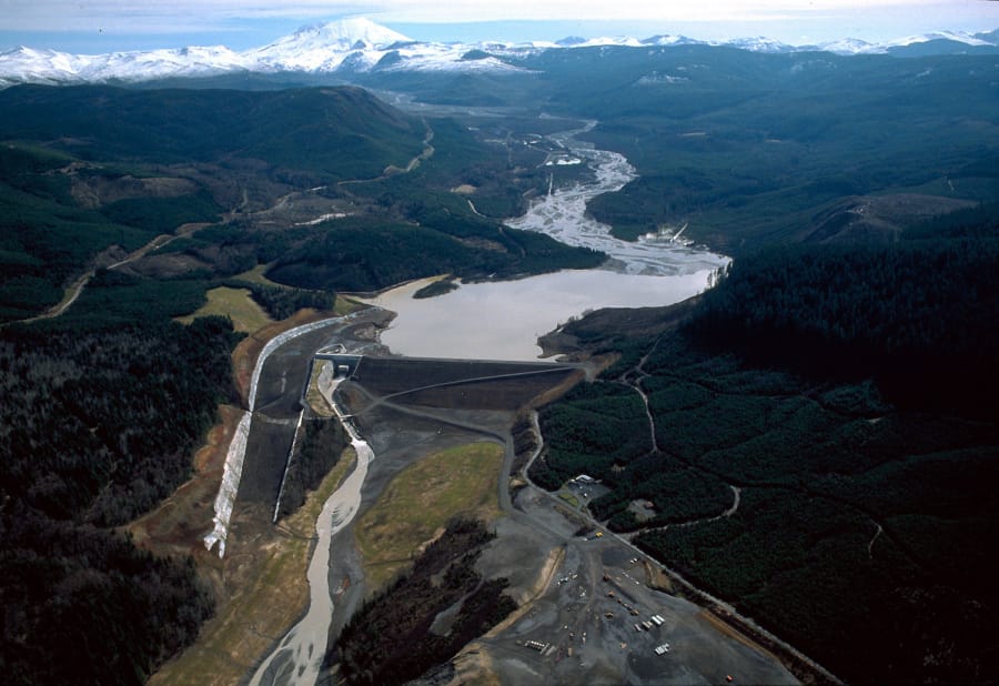
When the volcano’s north flank collapsed, nearly 3.3 billion cubic yards of debris toppled into the river valley in the largest landslide in recorded history. Mud flows raced down the North and South forks of the Toutle River, taking out bridges, 200 homes and sweeping up logs, railroad cars, trucks and buses as if they were toys.
Sediment clogged the Cowlitz and Columbia rivers, stopping shipping traffic for about a week.
“The USGS in particular sent people down to start doing water discharge measurements, sediment discharge measurements and cross sections to basically keep other agencies apprised of what the conditions were,” Spicer said. “(This research project) started from the get go.”
Spicer’s first glimpse of the river came in March 1981, when he started as a summer field intern with the USGS. Although he “had no particular interest in hydrology,” Spicer took the job because it was a step into the “outdoor career” he so desired. He unknowingly launched himself into a lifetime career studying water, sand and gravel in an unusually dynamic river.
“So much of tectonic plate movement and long-scale (geologic) processes are too long. Humans can only observe a snapshot … (because) it just doesn’t change very fast,” Spicer said. “Mount St. Helens is more like watching a movie, stuff is happening so fast.”
Even now, four decades after the eruption, the river continues to gouge, carve and smooth the debris-strewn valley floor. In one well-documented section of the river, water has scoured 850 feet wide and 127 feet deep.
And the Toutle is sweeping away almost 10 times more sediment downriver than it did before May 1980.
“This is actually a case study of (river stabilization),” Spicer said. “We are 40 years out and it’s not back to its normal situation yet. That argues to keep doing some monitoring on it.”
With so few chances to catch a river’s rebirth like this, Spicer’s Mount St. Helens research is a unique opportunity to study the large-scale, long-term development of a new landscape as a river resets.
“There are some projects that have long-term records. … But what sets St. Helens apart is just the sheer scale of it, and the degree of how much the initial landscape was changed,” Spicer said. “All of the drainage up there in the Upper North Fork Toutle is running over land that wasn’t there 40 years ago.”
Hazards not gone
As the river cuts its new course, it sluices immense amounts of sand downriver. Between 1998 an 2017, the river moved an average of 3.2 million tons of sediment annually, Spicer said. That’s enough sand to fill about 213,300 semi-trucks, which, if traveling together in a line, would roughly stretch from Portland to Los Angeles along Interstate 5.
That sediment can create sandbars, clog shipping channels or raise river levels, threatening river commerce and putting riverside communities at risk of flooding.
Mitigation efforts like dredging can offset those effects, but avoiding floods comes at a steep price. According to a 2018 study by the U.S. Army Corps of Engineers, the government will need to spend $384 million through 2035 to keep Longview, Kelso, Castle Rock and Lexington safe from river flooding related to continuing sediment runoff. That’s on top of hundreds of millions of dollars the agency already has spent to avert volcano-related flooding, including building a sediment retention dam and a Spirit Lake drainage tunnel in the wake of the 1980 eruption.
By Spicer’s general estimate, the river will continue to flush abnormal amounts of sand and silt downstream decades past 2035, when the federal authorization for Mount St. Helens flood control expires.
“That debris avalanche was massive and remains quite erodible. Every year that goes by some of it goes away … but on our time scale it’s an enduring problem,” Spicer said.
Even long after he’s retired is that “these (flood) hazards are not going away altogether. They’ve dwindled in some immediacy and the perceived threat has diminished, but it’s not gone.”
Spicer’s research provides the Corps with a “heads up” of the nature and severity of the river hazards it might be facing, so it can inform the Corps’ decisions on how best to manage any flood threats.
“You don’t know anything if you don’t monitor it,” Spicer said.
Passing the torch
Spicer shares his affinity for hydrology and grasp on how sediment flows affect everyday safety with his protege of nearly 10 years, Tami Christianson. The duo works together at the Cascade Volcano Observatory in Vancouver, and Christianson will likely lead Spicer’s project after he retires.
Christianson, 54, started working at the USGS in July 2008 as an “older than average student,” leaving previous careers in teaching and the food industry. Like her mentor, the chance to work in the USGS’ hydrology division “kind of landed in my lap.”
“Kurt had put out an ad to find student help, so my instructor connected me with him,” and she earned a spot on Spicer’s research team that turned into a full-time job once she graduated.
The last decade training under Spicer has been “more valuable than any of the classes I have been to,” she said. He knows history about the mountain beyond what’s documented in the sediment database, she said, and he is a hands-on mentor when they work together in the field.
Spicer hopes to provide similar training to a third, younger hydrologist who can carry the torch further into the future.
“Just looking at it from a pure numbers thing, probably I’ll retire, and then (Christianson) will retire not a whole lot longer after me. … The ideal in my mind is we bring on somebody anytime now and start this (training) process, rather than waiting until I’m gone,” Spicer said.
Although new USGS hydrologists won’t get the rare chance to watch a river evolve right from scratch, like Spicer did, they can continue to play a small, human part in documenting the enduring geologic story of Mount St. Helens.
“This is a longer process than my own lifespan or work career, so it does give one sort of commitment and feeling that this is valuable,” Spicer said. “The effort I make today to do this kind of monitoring, beyond just the fact that it’s what gets me a paycheck, it’s the knowledge that you are contributing toward this long-term monitoring that will inform future generations.”