TERREBONNE, Ore. — Navigating middle age and trying to maintain my fitness by running 25 to 30 miles a week is a grind.
And as I age, one thing becomes increasingly difficult on my runs: hills.
Lately, I had been sticking to flat trails, avoiding any sort of uphill challenge. On a recent Saturday, I stared that type of challenge right in the face, looking up at Burma Road at Smith Rock State Park.
Although Smith Rock is mostly known as a mecca for rock climbers, the trail running and hiking opportunities within the park should not be ignored. When the Central Oregon Cascades get covered in snow this time of year, Smith Rock offers vertical challenges for runners throughout the fall and winter.
That Saturday, a planned 7-mile trail run with my son Mason, 13, turned more into a hike/trail run. Burma Road was just too steep for me to keep running all the way up. But whatever disappointment I had in not running up, the entire climb was muted by the pristine beauty of the area on a crisp, clear fall day.
The loop route we chose, from Burma Road to the Summit Loop to the River Trail, allowed us to see as much of the park as possible, even from its highest vantage points — and no rock climbing was required. We were, however, able to watch many climbers make their way up the sheer rock faces that make the park a draw for sport climbing.
October is one of the best — and therefore most crowded — months in which to visit Smith Rock. We finally found a parking spot, paid the $5 fee (a Northwest Forest Pass is not valid at a state park) and took to the trail.
The path winding down to the main area of the park was filled with tourists, hikers and rock climbers on a sunny Saturday morning when temperatures reached the 60s. (Summertime is often uncomfortably hot at Smith Rock, so spring and fall seem to be the peak seasons.)
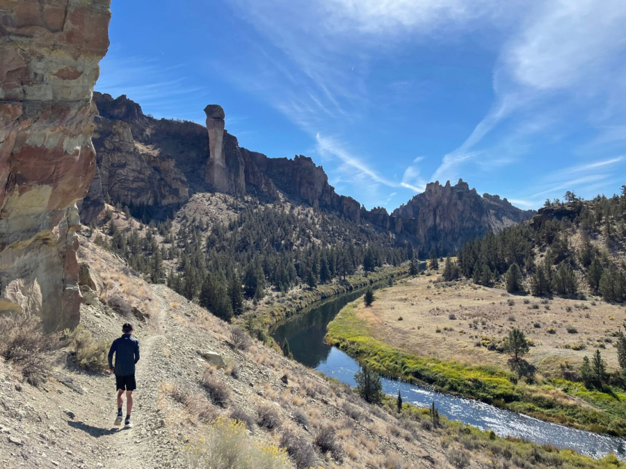
Seeking to avoid the crowds that were heading up the Misery Ridge Trail or along the River Trail, we took a right on the Wolf Tree Trail, which led us away from some of the more popular climbing destinations and into a more remote area of the park. The Crooked River trickled next to the trail as we continued running, and the sun shined on the castle-like crags that towered above the trail and the river.
Cliffs and rock spires
After tromping over a section of loose rocks, we turned onto Burma Road, where I had to switch from running to hiking. Burma Road cuts a wide swath across a barren hillside and is clearly visible from U.S. Highway 97.
When we reached the top, we took in the breathtaking cliffs and rock faces, a sort of bird’s-eye view of Smith Rock State Park.
From that spot, runners and hikers can continue east to the Gray Butte Trail (popular for mountain biking) or stay within the state park along the Summit Trail, which connects to the River Trail, which wraps around the park and parallels the Crooked River.
We followed the switchbacks of the Summit Trail down the hillside. Along the way, several viewpoints on the cliff side offered panoramic scenes of the rugged state park to the west and of the Crooked River National Grassland and Mount Jefferson to the northeast.
Eventually, we made it down all the switchbacks to flat ground and arrived at the connection to the River Trail. After we turned the corner to the north side of the park, Monkey Face, the renowned 350-foot rock spire, rose in the distance above the river.
The trail continued along the river, and soon thereafter we came to a junction with the Mesa Verde Trail, which leads to the base of Monkey Face.
Our choices were to continue along the flat River Trail and back around to the main parking area, or hike the steep Misery Ridge Trail up and over to the other side of the park.
We stared up at Monkey Face for a few minutes, watching two climbers make their way up the precipitous, exposed spire.
Mason and I decided to stay on the flat River Trail to complete the trek. As we jogged, Mason noticed a long-legged blue heron sitting on the far bank of the river, in addition to swans, geese and ducks.
Wrapping around to the other side of the park, we started to encounter more and more hikers as we entered the more popular climbing area.