SEATTLE — As fires begin torching Olympic National Park, the Columbia Basin and elsewhere, Pacific Northwest lawmakers and fire officials are bracing for a wildfire season that could be worse here than anywhere else in the U.S.
Experts predict an above-normal potential for wildfire for most of Washington and parts of Idaho, Montana and Oregon. It’s the culmination of lots of available grassy fuels and hot and dry conditions expected through the summer months.
Washington saw some of the fewest acres burned in a decade last year, after the second- and third-worst fire seasons on record in 2020 and 2021.
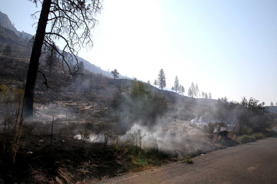
But the Bolt Creek Fire, which tore through more than 22 square miles of wilderness in eastern King and Snohomish counties last fall, may have been a dress rehearsal for more frequent fires along the western flank of the Cascades as climate change drives warming summers.
Experts say all of Washington will be vulnerable to fire this summer, and Washingtonians should prepare their homes for fire and smoke.
Center of fire activity
Last year’s quiet start to fire season highlighted the importance of a cool, wet spring. By mid-July, wildfires burned about 7,100 acres, or about 11 square miles, compared with roughly 320,000 acres the previous year.
This May, Western Washington saw precipitation around 5 percent to 25 percent of normal, said Matthew Cullen, a meteorologist with the National Weather Service. It was the second-warmest May on record.
Eight of Seattle’s 12 warmest Mays on record have occurred since 2013, Cullen said.
Meanwhile, average summer temperatures in 21 West Coast cities have risen by about 2.2 degrees since 1970, with Medford, Ore., seeing the highest climb, measuring nearly 5 degrees higher, according to a Climate Central analysis. The Seattle area’s average summer temperatures climbed by 3.2 degrees, according to the report, and about 23 days each summer have been above normal temperatures.
“We know what we’ve done to the atmosphere,” Washington climatologist Nick Bond said. “The things that we’re seeing with the heat, that is, the rises in temperature, have been more at night than during the day; that’s consistent with greater concentrations of greenhouse gases in the atmosphere.”
The region is also seeing drier summers, Bond said. The last two decades have been on the dry side, with some exceptions. But it’s hard to pin that on climate change because it could just be random variability, Bond said.
Predictions in a June 1 National Interagency Fire Center wildfire outlook showed the entire state of Washington lit up with above-normal fire potential from July through the end of September.
Federal and state agencies, like the state Department of Natural Resources, coordinate to produce the outlook.
“It does look like we’re in store for a well-above-average fire season in Washington,” said Matt Dehr, wildfire meteorologist for DNR. “And probably one of the worst fire seasons in the United States this year.”
Conditions primed
During normal conditions in the Pacific Ocean, the trade winds blow west along the equator, bringing warm water from South America toward Asia.
La Niña, when the trade winds are abnormally strong, carries tropical rainfall west and causes cool-water upwelling off the west coast of the U.S. This typically manifests in the Pacific Northwest as wetter and cooler weather.
After three years of La Niña, grasses exploded in the Columbia Basin and on the east slopes of the Cascades. Now, Washington’s grassy fuels are up to 10-year highs.
Some areas in Eastern Washington, like where the Okanogan Valley transitions into the Columbia Basin, and across the foothills of the Cascades where the grasslands run into forest land, have been identified as areas of concern by DNR. Fire can quickly tear through grasses and torch nearby timber.
“The bad thing is the fire danger is going to be high pretty much everywhere through the summer,” Dehr said. “Even west of the Cascades we’re a little bit concerned about how dry things are already looking.”
There are about 22 million acres of forests in Washington. About 43 percent are federal lands, about 20 percent are privately owned industrial lands, about 15 percent are nonindustrial private lands, roughly 12 percent are state-owned, and less than 10 percent are owned by tribal nations and local governments, according to estimates from the Washington Forest Protection Association.
Over 13 million acres of private and state lands are under state fire protection, according to DNR.
Western Washington is several inches behind normal precipitation for just the last 30 days and some areas are more than 10 inches behind normal precipitation for the last three months. Some areas of moderate drought have already been declared in Western Washington. Dehr said he expects that to get worse through the summer.
The worst of it, however, won’t be realized without an “ignition event” like high winds that coincide with heat and dry fuels, Dehr said.
In 2020, high winds helped fan the flames of 80 fires, and nearly 300,000 acres burned. But, during the 2021 heat dome, when temperatures soared above 105 degrees in Seattle and conditions were primed for devastating fires, Dehr said, a wind event never caused anything to ignite.
El Niño conditions arrived last month and could usher in a warmer, drier winter, which could be a cause for concern for the 2024 fire season, Dehr said.
Preparing land, homes
To prevent more severe wildfires as things heat up this summer, DNR has led prescribed burns on 637 acres in Central and Eastern Washington this year.
Prescribed fire has a long, rich tradition rooted in Indigenous ecological knowledge, but a University of Idaho study found there was no significant increase in prescribed burn acreage in the Western U.S. from 1998 to 2018, as wildfires became increasingly frequent and intense.
DNR in 2022 ignited the first prescribed burn season on state land in nearly two decades, marking a dramatic shift in land management. The practice can help cycle nutrients in the soil and create more open spaces and snags for animal habitat. The primary goal is reducing fuels for fires.
Since January 2017, DNR has tracked over 120,000 acres of prescribed fire across all land ownerships.
As the East Coast woke up to a dense blanket of smoke from hundreds of thousands of acres of forest on fire in Canada last month, a wildfire in Yakima County burned more than 800 acres, giving an early taste of wildfire season.
DNR had responded to more than 470 fires as of late last month, according to the agency. Even after a drizzly and cool Juneteenth weekend, most areas got no more than a half inch of rain, Dehr, the DNR meteorologist said.
“My whole state is in the forecast for this summer being in the epicenter of this,” U.S. Sen. Maria Cantwell said at a Senate Energy Committee hearing this month.
To prepare for fire season, people who live in what experts call the wildland urban interface, or the space where homes or other structures meet or intermingle with the natural environment, should create a defensible space around their home.
That could mean limiting the amount of flammable plants within 100 feet of the home. The area within 5 feet of the home should be clear of bark or mulch and plants containing oils or waxes. Homeowners should also prune low-hanging branches, and trim those near the home, porch and deck.
Homeowners can also sign up for the state’s Wildfire Ready Neighbors program, a collaboration between DNR, wildfire-preparedness experts, regional fire districts and communities across the state to equip those most at risk during fire season.