SEATTLE — BlackSky, the offshoot of a Seattle spaceflight company, spies on the world from space. Analyzing the images it collects with artificial intelligence, it delivers nearly real-time information to national security teams in the U.S. and other countries.
The images are beamed from satellites monitored from BlackSky’s operations office in South Lake Union and built in Tukwila by LeoStella, a joint venture half-owned by BlackSky.
Wall Street investors, consulting firms and major companies can also buy its economic intelligence: perhaps the size of coal stockpiles worldwide; barge shipments of commodities along the Mississippi; or the number of cargo aircraft Amazon is flying out of its main airfreight hub in Kentucky. After disasters, BlackSky images can detail the extent of damage and how relief work is progressing.
But most of BlackSky’s work is geared toward military intelligence for the U.S. and other governments.
In a video interview, CEO Brian O’Toole described how the troubled state of the world — the attack on Israel and its retaliation in Gaza, the war in Ukraine, the tension in Taiwan — fuels demand for the company’s technology.
“There’s just a growing demand for this type of intelligence from space,” he said. “It’s about real-time information for rapid decision-making.”
On Feb. 23, 2022, a day before Russia officially announced its invasion of Ukraine, BlackSky recorded a Russian strike on Ukraine’s Luhansk thermal power station.
In June, BlackSky tracked airplanes linked to Yevgeny Prigozhin, the Wagner Group leader, landing at a Belarusian air base following the mercenary group’s failed coup attempt in Russia.
In July, BlackSky revealed that China was secretly building a major naval port in Cambodia.
Last month, BlackSky released images of the Russian naval headquarters in Sevastopol, Crimea, before and after Ukraine destroyed it with a cruise missile.
Following the Hamas attack on southern Israel Oct. 7, BlackSky zoomed its satellites in on the region, including Gaza. Communications director Pauly Cabellon said BlackSky will release some of those images next month. Until then, “a customer” has paid for exclusive access.
“I can’t name customers,” said Cabellon, a former officer with the Marines. “I can’t name countries.”
O’Toole, speaking from BlackSky headquarters in Herndon, Virginia, talked about how the company decides to which countries it will sell imagery and intelligence.
In the turmoil of the Middle East, for example, Israel and surrounding Arab nations that are loosely partnered with the U.S. routinely spy on each other. All might want to buy BlackSky’s information.
Surprisingly, the U.S. government doesn’t make those decisions. BlackSky does, O’Toole said.
Because BlackSky operates its satellites under license from the U.S. government, it cannot provide services to the small number of countries blacklisted by the U.S., including Iran, North Korea, Syria and Yemen.
“Outside of that, we’re free to sell imagery to anybody else,” O’Toole said. “That includes the United Arab Emirates. That includes Israel. That includes China.”
“After that, it’s a kind of internal company policy as to who and where we sell to,” he added.
Still, one might expect some government oversight of what BlackSky can give to China, say, given that the Pentagon views China as the United States’ main future military adversary. But no, says O’Toole.
“No oversight,” he said, then adds, pointedly: “But we choose not to.”
BlackSky will attend the Dubai Airshow in the United Arab Emirates next month. “A large part of our growth is going to be overseas,” said Cabellon.
BlackSky has about 300 employees, many of them technical experts in aerospace systems, software and AI, but also including those with experience in the U.S. government and international affairs.
“Business decisions get based on really the long-term relationships that are in place with those customers,” O’Toole said.
Images on the hour
Google Earth cannot provide the imagery needed for the type of analysis BlackSky offers.
Indeed BlackSky claims no other commercial company can provide its close-to-real-time images, achieved by shooting high-resolution photos over a designated location of interest once every hour.
The big traditional satellite-makers in the U.S. are Boeing, Northrop Grumman and Lockheed. They make expensive, bus-sized satellites designed to stay in orbit 10 to 15 years.
Though there’s still a role for those specialized satellites, commercial space companies are rapidly changing the sector by launching into low Earth orbit thousands of small satellites, each costing just a few million dollars.
Most of those are for communications — e.g. SpaceX’s Starlink constellation or Amazon’s Kuiper — or for “Earth observation,” which means Google Earth-type imagery from companies such as San Francisco-based Planet Labs and Westminster, Colo.-based Maxar.
Planet Labs and Maxar have small constellations of satellites. But almost all orbit over the poles and are designed to pass over any designated spot on the globe exactly twice a day.
What the BlackSky constellation of 16 satellites offers uniquely is high-frequency visits.
“We’ve got a satellite flying over the building you’re in once an hour,” O’Toole said. “Delivering real-time intelligence is where BlackSky is set apart.”
BlackSky satellites orbit the Earth latitudinally in the opposite direction to Earth’s rotation. Concentrated above the part of the Earth where most humans live, the constellation allows much more frequent imaging.
Not a satellite company
Imagery is only part of what BlackSky provides.
“We’re not a satellite company,” says Cabellon. “We deliver intelligence.”
BlackSky started as part of Seattle’s Spaceflight Industries, which made satellites. It acquired Herndon-based geospatial analytics company OpenWhere, which provided software to analyze the images.
When BlackSky was spun off and went public in 2021, O’Toole, who had founded OpenWhere, moved the headquarters to Herndon, conveniently close to its U.S. government customer, and kept the satellite operation in Seattle.
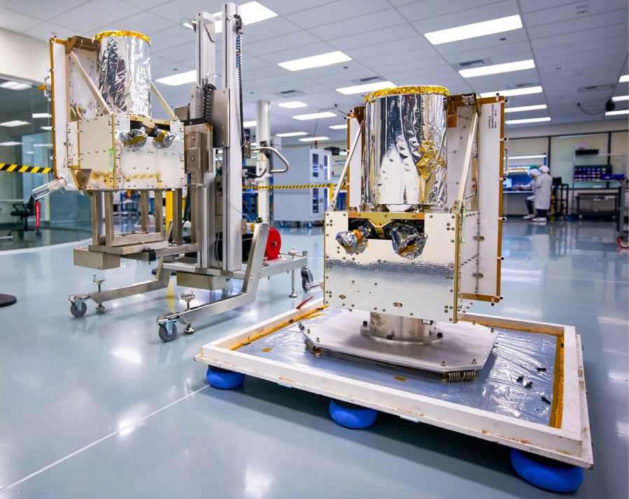
BlackSky formed LeoStella, a 50/50 joint venture with French Italian company Thales Alenia Space, to manufacture the satellites.
About 80 people work at the 22,000-square-foot LeoStella facility inside a former office building in Tukwila. The company is hiring, with a target of 100 employees by year-end.
“Seattle’s our expertise in satellites,” said O’Toole.
His team of more than 75 employees in Seattle designs the satellites, works with LeoStella, and from a mission station in the Seattle office monitors the health of the satellites in orbit.
The intelligence analysis happens in Herndon, where BlackSky employs data, artificial intelligence and machine learning experts as well as political and military analysts.
The company has created an analysis platform called Spectra that customers use to tell the satellites to look out for whatever they want to see.
The platform uses AI to scan the world’s news feeds, including hyperlocal foreign language sources, to identify emerging events. It can then automatically task satellites to take images of what’s happening.
And BlackSky customers can log onto Spectra and devise their own imaging searches.
“You can make the request yourself with no humans in the loop, and receive the imagery and automated intelligence inside 90 minutes, even from your mobile phone,” Cabellon said.
Showing off the technology inside a conference room, Cabellon pulls up images and data on Amazon’s main air cargo hub outside Cincinnati.
With hourly monitoring, “You can get a pretty clear picture of flight operations,” he said. “You can make estimations on how much economic activity is happening.”
And the platform could do the same at the main FedEx air hub in Memphis, Tenn. Would BlackSky sell such information to either or both competing companies? “Yes,” said Cabellon.
While O’Toole won’t talk about specific operations, it’s clear who is BlackSky’s most important customer.
“You can assume that we respond to U.S. government requests for collections for relevant events around the world,” he said.
Last year, the U.S. National Reconnaissance Office awarded BlackSky a $1 billion contract to provide intelligence over 10 years.
Beyond the use of BlackSky imagery in strategic planning, Cabellon said it can even deliver tactical intelligence and images to military units in combat, making it a “special forces/boots-on-ground tool.”
This week BlackSky won a new contract with the U.S. Air Force Research Laboratory, to build an “automated target recognition service” that will be able to “track mobile assets” so that the Air Force can send in aircraft to destroy them.
Despite the hefty government contracts and the demand for its technology, BlackSky has bled red ink ever since it went public in 2021. The latest financial filings show it posted a net loss of just over $50 million in the first six months of this year.
O’Toole is unfazed. He says the losses stem from heavy upfront investment that is only now bearing fruit.
“We’re in a growth phase where that investment for the last seven to 10 years is now fully deployed,” he said. “We’re ramping our revenues and driving toward profitability.”
Impressive as the technology is, the current BlackSky satellites are up for gradual replacement over the next few years. They can only see in the light, from dawn to dusk, and only in clear weather.
Looking out the office window on a rainy, cloudy October day in Seattle, Cabellon concedes that “especially during these months, it’s hard for us to get imagery.”
Next year, BlackSky will begin launching its newly designed third-generation satellites with more capability. They’ll deliver higher-resolution images and include shortwave infrared scanning that will enable imaging at night and through clouds.
LeoStella is now testing the final second-generation BlackSky satellite and gearing up to build the new-design satellites that will replace the current constellation.