• Boundary trail: Follow Interstate 5 north to exit 49 at Castle Rock. Then head east up state Highway 502 for 52 miles to the parking lot at Johnston Ridge Observatory. The Forest Service charges an $8 per person day use fee for the north side of Mount St. Helens.
• Riley Creek trail: From the intersection entering Trout Lake, go right to the junction with Gifford Pinchot road No. 23, then left on No. 23. The distance from the intersection to the trailhead is 18.9 miles. The trailhead is between mileposts 38 and 37 (they decrease going north). The “trailhead’’ parking is basically room to park three cars on the west side of road No.23 at the start of the trail.
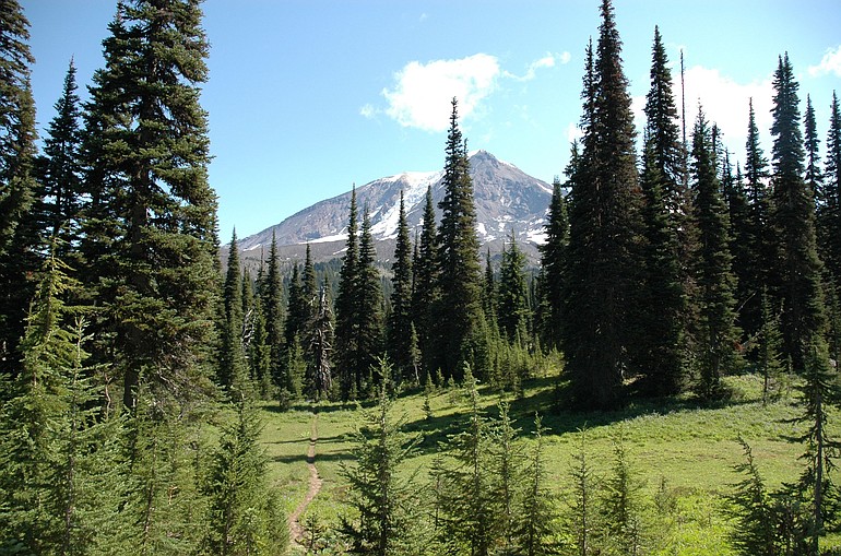
The two signature spots of the sprawling Gifford Pinchot National Forest are its snow-capped peaks — attention-hog Mount St. Helens and lesser-used Mount Adams.
This summer will be a great time to experience the two mountains intimately, by walking into their backcountry on the following pair of recommended hikes.
• Boundary trail: Follow Interstate 5 north to exit 49 at Castle Rock. Then head east up state Highway 502 for 52 miles to the parking lot at Johnston Ridge Observatory. The Forest Service charges an $8 per person day use fee for the north side of Mount St. Helens.
• Riley Creek trail: From the intersection entering Trout Lake, go right to the junction with Gifford Pinchot road No. 23, then left on No. 23. The distance from the intersection to the trailhead is 18.9 miles. The trailhead is between mileposts 38 and 37 (they decrease going north). The "trailhead'' parking is basically room to park three cars on the west side of road No.23 at the start of the trail.
Both of these trips are long day hikes, best done in the prime weather of late July to early September when the sun still comes up early and sets late.
Here are the details:
• Mount St. Helens
Even newcomers to Southwest Washington know of Mount St. Helens, given how it blasted its way to worldwide notice almost 31 years ago. It’s an easy mountain to see, starting with the spectacular Johnston Ridge Observatory on the northwest side at the end of state Highway 504.
But Johnston Ridge Observatory really is the beginning, not the culmination, of a visit to America’s top volcano.
Boundary trail No. 1 heads east from Johnston Ridge Observatory. Many folks hike it 1 to 2 miles out and back, taking in great views of the crater of Mount St. Helens and Spirit Lake.
Most hikers head back by Devils Elbow, a hairpin turn 2.2 miles from the trailhead.
They miss the best part of the trail. They miss not only seeing the devastation, but how the land is coming back, by not continuing on to Coldwater Peak.
In a nutshell, this hike is 5.94 miles on the Boundary trail to the junction with Coldwater Peak trail No. 1, then a steep 1.03 miles with 700 feet elevation gain to the summit of Coldwater Peak. Being 14 miles round trip, it’s an all-day jaunt.
For the initial five miles heading east from Johnston Ridge Observatory, the Boundary trail seems much like other routes in the blast zone — dry and dusty, with flowers, brush and trees slowly reclaiming the terrain. Then, the trail enters the basin containing sapphire, 79-acre St. Helens Lake.
The basin is mostly green, with additional varieties of wildflowers. Scattered about are the bleached and standing lower portions of the big trees snapped off here on May 18, 1980.
From atop Coldwater Peak, St. Helens and Spirit lakes sparkle and shimmer to the east, Mount St. Helens’ gaping crater towers to the south, and the sweeping Toutle River valley unfolds to the west.
And this ridgetop, panoramic view — available while sitting amid penstemon, paintbrush and other colorful wildflowers — isn’t even the highlight of the trip. What everyone remembers is the hole in the rock.
There’s a huge opening where the Boundary trail passes through a natural arch, traversing from the west to the east side of a ridge. The hole in the rock is 5.18 miles from the trailhead.
The arch existed before the May 1980 eruption. It is shady on a hot day and serves as a cooling funnel for the predominating westerly breeze.
There’s no fishing, and no off-trail travel in St. Helens Lake basin. The Forest Service limits backcountry camping north of Mount St. Helens to eight designated spots.
Three camps are along Boundary trail No. 1 northeast of St. Helens Lake, one camp is on Coldwater trail No. 230 and four camps are near lakes north of Mount Margaret.
Camping permits are required. The permits are free, but need a Northwest Forest Pass ($5 daily, $30 for 12 months) to be valid.
• Mount Adams
Riley Creek trail No. 64 passes through meadows and along small lakes to great views on the west side of Mount Adams. Most Gifford Pinchot National Forest maps show the route, but not all of them. Riley Creek trail is not included on the Pinchot website.
Suffice to say, this is hike where you might have a nice chunk of Mount Adams Wilderness to yourself. Riley Creek trail begins on Randle-Trout Lake road No. 23 north of Twin Falls and south on Noname creeks. It climbs 4.5 miles and 2,280 feet elevation to junction with the Pacific Crest National Scenic Trail No. 2000 near Sheep Lake.
This is the only trail on the west side of Mount Adams between the Crest trail on the southwest and Divide Camp trail No. 112 on the northwest side.
Starting at road No. 23, the Riley Creek trail climbs fairly steeply through the trees for 1.17 miles to a junction. At this junction, stay left, passing the wilderness boundary sign and coming to Sled Camp. A side trail leads left to a flat that’s either meadow or tarn, depending on how wet or dry the year. Look closely, there’s what’s left of an outhouse near the junction.
Stay on Riley Creek trail and keep climbing for another 1.2 miles (2.4 miles total) to a two-acre lake in a bowl off to the left. The lake is at 5,107 feet elevation.
This and another nearby off-trail lake get stocked intermittently with golden trout.
Once at the lake, the worst of the climbing is over. The trail continues, passing intermittent tarns, to the large Riley Creek meadows in another 1.6 miles (4 total). This is a great spot to camp, and at least three fire rings are scattered about the meadows.
Riley Creek also is a very easy place to take a wrong route and never make the Pacific Crest trail.
Once across Riley Creek, make a hard right turn and continue upstream along the creek. There’s an old trail straight ahead at the Riley Creek crossing that starts to drop and head northwest toward Mutton Creek.
Continue through the meadow with Riley Creek on the right. The trail gets faint as it passes some sand and gravel stream debris. Push through the sand and gravel stretch and the trail tread heading up the hill reappears.
From the crossing of Riley Creek to the junction with the Crest trail is 0.5 mile, bringing the total to 4.5 miles.
With all the lupine, paintbrush and other wildflowers, this stretch of the Crest trail is delightful. At a minimum, hike south (right) for 0.28 miles to Sheep Lake, where several camping spots are available.